Download presentation
Presentation is loading. Please wait.

1
Tornadogenesis: Unknowns Erik Rasmussen, Rasmussen Systems Jerry Straka, OU Kathy Kanak, CIMMS 2009 College of DuPage Storm Conference

2
tornado—1. A violently rotating column of air, in contact with the ground, either pendant from a cumuliform cloud or underneath a cumuliform cloud, and often (but not always) visible as a funnel cloud.
 visible as a funnel cloud..")
3
Tornadoes and Tornado Cyclones What are they and why should we care?

4
tornado—1. A violently rotating column of air, in contact with the ground, either pendant from a cumuliform cloud or underneath a cumuliform cloud, and often (but not always) visible as a funnel cloud. What is violent? Vortices generally increase in windspeed as they contract in radius. So intensity is partially dependent on the degree of contraction.
 visible as a funnel cloud. What is violent. Vortices generally increase in windspeed as they contract in radius. So intensity is partially dependent on the degree of contraction..")
5
tornado—1. A violently rotating column of air, in contact with the ground, either pendant from a cumuliform cloud or underneath a cumuliform cloud, and often (but not always) visible as a funnel cloud. Funnel vs. tornado issue? Note Markowski et al. (MWR 2002, pp. 1692-)
 visible as a funnel cloud. Funnel vs. tornado issue. Note Markowski et al. (MWR 2002, pp ).")
6
tornado—1. A violently rotating column of air, in contact with the ground, either pendant from a cumuliform cloud or underneath a cumuliform cloud, and often (but not always) visible as a funnel cloud. Probably to filter against dust devils, etc. “Pendant” is essentially impossible from a physical perspective.
 visible as a funnel cloud. Probably to filter against dust devils, etc. Pendant is essentially impossible from a physical perspective..")
7
tornado—1. A violently rotating column of air, in contact with the ground, either pendant from a cumuliform cloud or underneath a cumuliform cloud, and often (but not always) visible as a funnel cloud. A funnel cloud is a condensation pressure surface within a vortex. It is not the vortex itself, which physically must be larger than the funnel.
 visible as a funnel cloud. A funnel cloud is a condensation pressure surface within a vortex. It is not the vortex itself, which physically must be larger than the funnel..")
8
tornado—1. I know one when I see one.

9
A B B A

10
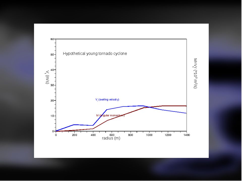
Angular momentum M=Vr = tangential, swirling velocity times radius. Dimmitt tornado, 2 June 1995. From single- Doppler analysis. M=14000 contour

11
Approximate swirling windspeed and angular momentum in the Dimmitt tornado early in mature stage about 200 m above the ground.

13
This flow would evolve from the previous in < 5 minutes with a modest inflow of (e.g.) about 5 m/s at 500 m radius
 about 5 m/s at 500 m radius")
14
As the high-M air penetrates closer to the axis, maximum swirling wind speed ~doubles for each halving of the radius of penetration of the large M region.

15
Thoughts... Most supercells probably have tornado cyclones. Nomenclature isn't so important as understanding that... A tornado, whatever wind speed or appearance criteria that are used, is the inner portion of a tornado cyclone where enough angular momentum has been transported toward the axis to give tornadic windspeeds.

16
Thoughts... Tornadogenesis failure is possibly simply a failure of contraction of the tornado cyclone. Strength of the inner portion of the vortex (the tornado) depends on angular momentum in the outer portion, and the removal of mass upward through the vortex (and hence convergence below).
 depends on angular momentum in the outer portion, and the removal of mass upward through the vortex (and hence convergence below)..")
17
Thoughts... Hence we seek to understand why most supercells are not conducive to transporting sufficient air upward through the tornado cyclone to increase the vortex to tornado strength. Operationally, if tornado cyclones are even close enough to the 88D for detection, the differences between tornadic and non-tornadic TCs may almost always lie at unresolvable scales.

18
Thoughts about EF scale and tornado windspeeds (needed?) See if this can be tied to the science of the talk; else delete.
 See if this can be tied to the science of the talk; else delete.")
19
So how did the Tornado Cyclone come into existence? Here are some historically validated observations about the supercell:

20
Common supercell features: Updraft acquires horseshoe shape. Counter-rotation is observed. A Rear-Flank Downdraft is present in the interior of the horseshoe pattern. The tornado cyclone is centered in strong vertical velocity gradient on the interior left edge of the horseshoe. A gust front is present below the rear edge of the updraft.

24
A simulation... Horseshoe- shaped updraft Rear-Flank Downdraft Counter- rotating vortices Vortex straddles up/downdraf t

25
Initial conditions

26
RFDs Again, classification may get in the way. Occlusion downdraft vs RFD; buoyancy vs. dynamic. Back to Markowski... DD must be involved. Q2: RDF forcing Q1: RFD buoyancy vs. height Q3: Rear-side precipitation role

27
RFDs Arching vs tilting of near-ground inflow... is either necessary? Is either sufficient?

28
Tornado longevity Is the tornado just a spin-down process of TC. Is a tornado maintained somehow (and maybe is a TC maintained somehow)? Degree of occlusion? WHy shorter-track before longer- track? (Track length product of duration and forward motion; is duration the key scientific issue?
. Degree of occlusion. WHy shorter-track before longer- track. (Track length product of duration and forward motion; is duration the key scientific issue .")
29
Role of the Mesocyclone Not direct? Straka et al. Already showed that very “tornadic looking” features can be formed when precip occurs at the side of an updraft IN TOTAL ABSENCE OF FLOW HENCE SHEAR Is the role of a meso to deposit precip at a location that is effective for arching?

30
The supercell environment Deep environmental structure Near-ground importance Why flee big CAPE (you don't need no Shtinkin' CAPE) Why does big CAPE seem to be special on some days? Alternative hypotheses, and the earlier studies [Check blog post to students]

31
Thank you! This research is supported by you through the National Science Foundation rasm1@rasmsys.com http://www.rasmsys.com

Similar presentations


 that may contain a stratiform rain region.>")
 Lemon, L. R., and C. A. Doswell III, 1979: Severe thunderstorm evolution and mesoscyclone structure as related to tornadogenesis.>")


 Weisman, M. L., 1992: The role of convectively generated rear- inflow jets in the evolution of long-lived mesoconvective systems. J. Atmos.>")


