Download presentation
Presentation is loading. Please wait.

1
River Processes and Landforms

2
The Hydrological (Water) Cycle
 Cycle")
3
The River System – the drainage basin.
A river system is an open system. An open system has inputs, processes and outputs. So unlike water in the hydrological cycle, where there is an endless cycle of rain, rivers, sea and evaporation, water in the river system enters the system, and eventually leaves it again. A river system operates inside a drainage basin (or river basin). A drainage basin is the area of land drained by a river and its tributaries. Any water falling inside the drainage basin will find its way into the main river channel (unless it is taken out of the system - for example by being piped to a factory). The boundary of a drainage basin is called the watershed. The diagram below shows a drainage basin. Make sure you know all the key terms used when talking about river systems. The River System – the drainage basin.
. A drainage basin is the area of land drained by a river and its tributaries. Any water falling inside the drainage basin will find its way into the main river channel (unless it is taken out of the system - for example by being piped to a factory). The boundary of a drainage basin is called the watershed. The diagram below shows a drainage basin. Make sure you know all the key terms used when talking about river systems. The River System – the drainage basin.")
4
Processes at work From the source to mouth of a river three processes are taking place River Erosion River Transport River Deposition River Erosion River Transport River Deposition

5
River Erosion Processes: Attrition
Processes: Corrasion, (abrasion) is the grinding of rock fragments carried by the river against the bed and banks of the river. This action causes the channel to widen and deepen. This grinding is most powerful in flood time when large fragments of rock are carried along in the river bed. Attrition Attrition is the collision of rock fragments in the water against one another. The rock particles are broken into smaller pieces and become smoother the longer the process continues. River Erosion
 is the grinding of rock fragments carried by the river against the bed and banks. of the river. This action causes the channel to widen and deepen. This grinding is most powerful in flood. time when large fragments of rock are carried along in the river bed. Attrition. Attrition is the collision of rock fragments in the water against one another. The rock particles are broken into smaller pieces and become smoother the. longer the process continues. River Erosion.")
6
River Transport Solution
Solution (corrosion) is the process by which river water reacts chemically with soluble minerals in the rocks and dissolves them. An additional process is also at work caused by the force of the water itself known as Hydraulic action. In this rocks are dragged away from the bed and banks by the force of the running water. When water from a fast moving stream enters minute cracks in a rock, the pressure exerted weakens and eventually breaks up the rock River Transport A river carries or transports eroded materials such as mud, sand, boulders and dissolved materials on its journey. These materials are known as its load. The load is carried along by three processes. traction suspension solution Traction Is where boulders or stones are rolled along the stream bed by the force of the water
 is the process by which river water reacts chemically with soluble minerals in the rocks and dissolves them. An additional process is also at work caused by the force of the water itself known as Hydraulic action. In this rocks are dragged away from the bed and banks by the force of the running water. When water from a fast moving stream enters minute cracks in a rock, the pressure exerted weakens and eventually breaks up the rock. River Transport. A river carries or transports eroded materials such as mud, sand, boulders and dissolved materials on its journey. These materials are known as its load. The load is carried along by three processes. traction. suspension. solution. Traction. Is where boulders or stones are rolled along the stream bed by the force of the. water")
7
River Deposition Suspension
Fine particles such as clay, silt and fine sand are carried along in the river. Solution Dissolved materials containing minerals like calcium and sodium are carried in the water and are invisible to the naked eye. River Deposition A river drops its load when the speed or volume of the river decreases. The load, which it carries, is deposited. The heavier material is deposited first and the finer material carried further. Rivers reduce their speed when they enter flat land, enters a lake or the sea or reach an arid area. The volume can be reduced during a dry season or when the river passes over more porous landscapes e.g. sand or limestone.

8
Video of river processes:

9
Click on the link below to see this animated.
How a river transports Click on the link below to see this animated.

10
What is the long river profile?

11
A typical long profile:
River Valley Development A river has a life cycle from source to mouth. The processes at work cause changes to the river valley and river features in the landscape that it passes over. Traditionally this cycle has been described in 3 stages, the Upper (Torrent) section, the Middle (Valley) section and the Lower (Flood Plain) section. The terminology's Youthful, Mature and Old have also been used to describe the sections. The stages are not clearly defined but merge from one to the other and rivers show individual characteristics. There are river features that can be defined within a broad pattern. A typical long profile: upper middle lower
 section, the Middle (Valley) section and the Lower (Flood Plain) section. The terminology s Youthful, Mature and Old have also been used to describe the sections. The stages are not clearly defined but merge from one to the other and rivers show individual characteristics. There are river features that can be defined within a broad pattern. A typical long profile: upper. middle. lower.")
15
Watch videos: from source to mouth

16
Which stage? How do you know?

17
2. How do you think the channel shape changes here?
1. How much energy do you think the river has here? How do you think the river uses its energy here? 2. How do you think the channel shape changes here? 3.In which direction is the river eroding here? How do you know? 4. Do you think the river is at its fastest here? What do you think happens to velocity as you travel downstream? 5. What do you think the rivers load is like here? Why? Where does its load come from? 6. What processes of erosion do you think may be happening here? 7. How do you think the river transports here? 8. Do you think deposition occurs here? If yes when? 9. What landforms do you find in the upper stage?

18
Upper Course Characteristics: Deep narrow valley (V shaped)
Interlocking spurs Fast flowing river (erosion predominant) Pot holes in the river bed Rapids and Waterfalls The main process at work is the downward or vertical erosion of the stream bed. This cuts into the landscape deepening the valley sides.
 Pot holes in the river bed. Rapids and Waterfalls. The main process at work is the downward. or vertical erosion of the stream bed. This. cuts into the landscape deepening the valley. sides.")
19
Interlocking Spurs As the water twists around obstacles such as rocks and boulders the erosion forces undercut outward bends and a snaking pattern is produced. From lower down the interlocking of the spurs of land between the bends blocks the view up the valley. V-shaped valley with interlocking spurs

20
Click on the link below to see this animated.
Interlocking Spurs

21
Interlocking Spurs

22
Potholes: Potholes are formed by corrasion. Pebbles carried by the river are swirled around on the riverbed. This action erodes the rock on the riverbed forming potholes. Over time, they may widen and join with other potholes to form larger potholes, and the whole riverbed is deepened.

23
RAPIDS

24
Rapids: Rapids are stretches of fast-flowing water tumbling over a rocky-shallow riverbed. Different resistance among rocks cause rapids. They are formed when the water goes from one hard rock that resists the water's erosion to a softer rock that is easier eroded.

25
Waterfalls

26
Waterfalls: Waterfalls occur when a band of hard rock lies across the river with softer rock downstream which is more rapidly eroded. At first rapids would form but then develop into a waterfall as the softer rock erodes further. Variations may be caused by the rock structure. (1) Rock layer is horizontal (2) Rock layer dips upstream
 Rock layer is horizontal. (2) Rock layer dips upstream.")
27
Click on the link below to see this animated.
(3) Rock layer is vertical Click on the link below to see this animated.
 Rock layer is vertical. Click on the link below to see this animated. GroupId=12426&ResourceID=")
28
How does a waterfall form?

29
In summary

30
Watch video: waterfall formation

31
WHAT ARE MEANDERS?

32
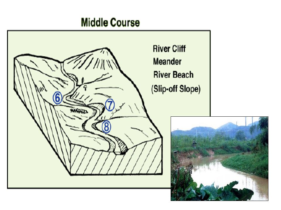
Middle-course features
Meanders In the middle course the river has more energy and a high volume of water. The gradient here is gentle and lateral (sideways) erosion has widened the river channel. The river channel has also deepened. A larger river channel means there is less friction, so the water flows faster: As the river erodes laterally, to the right side then the left side, it forms large bends, then horseshoe-like loops called meanders. The formation of meanders is due to both deposition and erosion. The force of the water erodes and undercuts the river bank on the outside of the bend where water flow has most energy. On the inside of the bend, where the river flow is slower, material is deposited.
 erosion has widened the river channel. The river channel has also deepened. A larger river channel means there is less friction, so the water flows faster: As the river erodes laterally, to the right side then the left side, it forms large bends, then horseshoe-like loops called meanders. The formation of meanders is due to both deposition and erosion. The force of the water erodes and undercuts the river bank on the. outside of the bend where water flow has most energy. On the inside of the bend, where the river flow is slower, material is deposited.")
33
Watch video of meander formation!
What happens at a meander? Watch video of meander formation!

35
Slow, shallow water and deposition on the inside of the bend
Deep, fast water and erosion on the outside of the bend

36
What is an ox-bow lake?

37
Click on the link below to see this animated.
What is an ox-bow lake? Click on the link below to see this animated.

38
LOWER STAGE: FLOODPLAINS

39
LOWER STAGE: LEVEES

Similar presentations