Download presentation
Presentation is loading. Please wait.

1
Project Planning

2
Project Plans - Objective The participant will be able to understand the purpose of a Project Plan and how the Project Plan is integrated into Management of Soil Survey by MLRA

3
Project Plans (NSSH 610) Priority Items from Long Range Work Plan Developed by the Technical Team in the context of the entire MLRA Soil Survey Area Address needs of the majority of users Focus on specific groups of soils and associated interpretations
 Priority Items from Long Range Work Plan Developed by the Technical Team in the context of the entire MLRA Soil Survey Area Address needs of the majority of users Focus on specific groups of soils and associated interpretations")
4
Project Plans Agreed upon by the Soil Survey Area Management Team – State Soil Scientists with an interest in the MLRA Soil Survey Office

5
Project Plan Vision Micheal Golden, Director, Soils Division Should Project plans should be based on the map units affected? Yes Should multi-year projects should be broken down to annual projects for reporting purposes? Yes, In fact many projects may be just months in length and the office will have multiple projects within a year.

6
Project Plan Vision Micheal Golden, Director, Soils Division Are two year projects okay? YES - these could be separated by reportable milestones. Is the emphasis on the completion of a project? YES - in most cases projects will not be to redraw lines but will have database population, correlation, and documentation as the main objectives. Are project acres reported when delivered to the Soil Data Mart? YES

7
Project Plan Vision Micheal Golden, Director, Soils Division Not enough time to redraw all the lines on a 15 million acre MLRA Soil Survey Area Join and correlate and populate the database the best we can so we have a seamless product. Review map units to determine if the soils are adequately described & documented & that the database is complete and accurate.

8
Project Plan Vision Micheal Golden, Director, Soils Division Up to the Management Team to decide how much or how little time should be devoted to updating the soil map units. A methodical approach in looking at each geology and catena of geographic extent of soils is a wise approach. Utilize NCSS cooperators to do outside research NSSC Lab liaisons to contribute and help with research and sampling

9
Project Plan Vision Micheal Golden, Director, Soils Division We will hopefully be surprised that we have enough data and knowledge to support the map units. The Soil Survey success will be measured by our ability launch this effort to update the soil survey by catena and sets of map units.

10
Project Planning All projects gleaned from the LRP are entered into NASIS The project table is populated for all projects The project child tables are populated for Approved projects The detailed evaluation is the first project milestone for an approved project

11
Creating the “Project” Open the Tables Explorer panel, then Project table and insert a new row

12
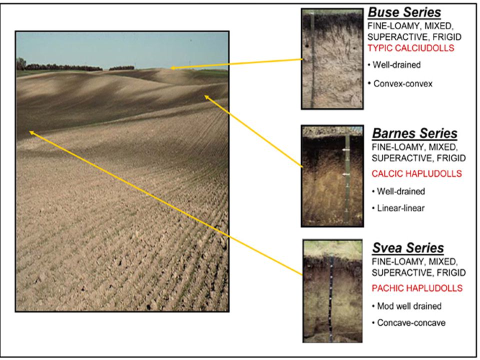
PROJECT PLAN Evaluation of MLRA 55 Barnes-Buse Map Unit (one of the Soil-Landscape issues from the Long Range Plan)
")
13
Project Plan – Objective Evaluate map unit composition of eroded fine- loamy glacial till found on 3-6 percent slopes in cropland. From composition percentages a map unit name will be developed and an MLRA Symbol assigned. A new map unit will potentially be correlated across MLRA 55.

14
Project Plan - Justification and Significance Map units may not correctly represent the terrain Map units exist in thirteen of sixteen counties in MLRA 55 Includes Benchmark soils such as the Barnes Series Soils are among the most productive in the MLRA& extremely important to conservation planning Impact of erosion on the North Dakota Soil Productivity Index

17
Project Name and Description At a minimum, all project plans will include this information. Project names begin with the MLRA space dash space then project name Description is used as an “Executive Summary” Identify the MLRA SS office and the state

18
Project Plans in NASIS From concept to project (broken down into manageable projects) Project Name includes the “MLRA 55 – “
 Project Name includes the MLRA 55 –")
19
The description column should provide the justification, significance, background, benefits Project Plan - and Significance Project Plan - Justification and Significance

20
Approved Projects NASIS 6.1 will include an “Approve” flag Approved projects will have a detailed evaluation completed on all map units as the first step of the Project

21
Project Plan – General Procedure Locate the eroded fine-loamy till landscapes found on 3 to 6 percent slopes Identify map units used Choose representative map units to investigate from the geographical distribution

22
Project Plan – Map Units

23
Project Plan – Milestones Transects of the eroded landscape, focusing on eroded areas and depositional areas Determine composition percentages and develop map unit name Correlate the map unit across MLRA 55 Review spatial data

24
Project Plan - Milestones Milestones are used to capture important activities within the project

25
Project Milestone Progress Report milestone progress

26
Project Plan – Other Items Equipment Duration & Timeframe (fits into APO) Personnel (who & when)
 Personnel (who & when)")
27
Project Plan – Other Items Project Staff Include all members associated with the Project including MLRA Regional Office staff and NSSL liaison, if assistance is needed

28
Project Plan – Other Items Review existing correlation documents Correlation documented in NASIS NASIS Data Updated Export to Soil Data Mart – WEB Soil Survey

29
Correlation Correlation documentation is entered into the Project Correlation table Project child tables are used to document and manage project needs

30
Project Mapping Goals Acres are goaled by staff member

31
Project Reporting

32
Reporting Products Project child tables provide the SSL a field to identify the various products

33
Project Text Used to record old project or investigation plans (assuming you need more than 240 characters) or notes on the specific project
 or notes on the specific project")
34
Quality Control, Quality Assurance, and Soil Correlation (NSSH 609) Ensure objectives of Project Plan are met State Conservationist concurs in Project selected Determine if documents Long Range, Project Plan, & Annual Plan of Operations are current Does level of detail on mapping conform to the objectives of the project plan Are interpretations consistent with the purposes of the survey as described in the project plan
 Ensure objectives of Project Plan are met State Conservationist concurs in Project selected Determine if documents Long Range, Project Plan, & Annual Plan of Operations are current Does level of detail on mapping conform to the objectives of the project plan Are interpretations consistent with the purposes of the survey as described in the project plan")
35
Project Plans – new concept Multiple projects worked on at the same time Each project will have different timeframes Each project will require a different approach & staff skills Each project may have a different group interested in the outcome

36
Project Plans – new concept Soils staff at all levels of the NCSS need to develop and utilize effective planning tools and approaches Over the next few years we will collectively test and refine the best approaches The best ideas will come from the MLRA Soil Survey Leaders since they will be managing the plans

38
Ideas on project planning Written definition of the problem Written specifications (to avoid changing goals in mid-project) Work Breakdown – activities to complete Task allocation – know your team Realistic time estimates
 Work Breakdown – activities to complete Task allocation – know your team Realistic time estimates")
39
Ideas on project planning Involve staff & Technical Team members Explicit plans to test for quality (avoid futile quests for perfection) Avoid “scope creep” Plan for errors (something is going to go wrong) Unambiguous targets
 Avoid scope creep Plan for errors (something is going to go wrong) Unambiguous targets")
40
Ideas on project planning The MLRA Soil Survey Office staff & Technical Team develops one or more project plans Priorities are set by the Management Team Coordinate spatial and tabular information across existing soil survey area boundaries following natural landforms. Projects, in most cases, will concentrate on database population, correlation, and documentation.

41
Project Plan Definition (NSSH 610) Based on the prioritized inventory of needs in the long range plan, identify specific priorities within the MLRA soil survey area that can be accomplished within a set timeframe
 Based on the prioritized inventory of needs in the long range plan, identify specific priorities within the MLRA soil survey area that can be accomplished within a set timeframe")
42
Project Plans in NASIS Required to enter all management team approved project plans in NASIS Optional but encouraged to enter all project plans with at least a brief description of it objectives –How else will anyone coming in behind you know what these plans are meant to accomplish

43
Additional information Read Chapter 14 of the NASIS Users Guide

Similar presentations


. Rationale To develop a work plan, you must have some realistic time estimates of what you can do within the time to be planned.>")


