Download presentation
Presentation is loading. Please wait.

1
THE NEW FLOOD HAZARD AREA CONTROL ACT RULES
STATE OF NEW JERSEY DEPARTMENT OF ENVIRONMENTAL PROTECTION VINCENT J. MAZZEI, JR., PE March 13, 2008

2
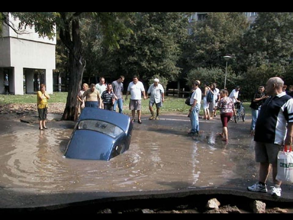
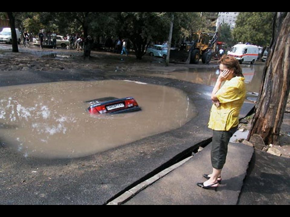
The Floods Between 1994 and 2003: Between 1996 and 2006:
New Jersey residents filed more than 19,000 flood insurance claims New Jersey residents received nearly 1/4 billion dollars in flood insurance payments Between 1996 and 2006: Nine Major Disaster Declarations by FEMA in NJ related to flooding

3
HISTORY 1929: Stream encroachment program begins
1962: State begins mapping 100-year flood plains 1975: NJDEP adopts floodway rules 1977: 0% net-fill instituted in Central Passaic Basin 1984: 20% net-fill instituted Statewide 1995: Previous rules with 25-ft & 50-ft buffers adopted

6
“Flooding is New Jersey's
#1 Natural Hazard” (FEMA, August 4, 2004)
")
7
Flood Mitigation Task Force
April 18, 2005: Acting Governor Codey forms Flood Mitigation Task Force August 22, 2006: Governor Corzine releases final task force report Recommended sweeping changes to New Jersey’s policies regarding development in flood hazard areas and riparian corridors

8
The New Rules Proposed: October 2, 2006 Received: 1,023 comments
Effective: November 5, 2007 Posted:

9
Theme No Adverse Impact: Ensuring that “…the action of one property owner does not adversely impact the rights of other property owners, as measured by increased flood peaks, flood stage, flood velocity, and erosion and sedimentation…” (Association of State Floodplain Managers, NAI White Paper, April 29, 2004)
")
10
Goals Ensure flooding does not increase Preserve flood storage
Prevent obstructions to flow Protect public safety Construct new buildings and roads above the flood hazard area elevation Provide healthy riparian corridors Preserve vegetation Protect habitat

11
Jurisdiction THREE STEPS
Determine if you are along a regulated water (N.J.A.C. 7:13-2.2) Determine if you are within a regulated area along this water (N.J.A.C. 7:13-2.3) Determine if you are proposing a regulated activity (N.J.A.C. 7:13-2.4)
 Determine if you are within a regulated area along this water (N.J.A.C. 7:13-2.3) Determine if you are proposing a regulated activity (N.J.A.C. 7:13-2.4)")
12
Step 1: Regulated Waters
All waters are regulated except: Manmade canals: N.J.A.C. 7:13-2.2(a)1 Coastal wetlands: N.J.A.C. 7:13-2.2(a)2 Waters that drain less than 50 acres in three particular cases described at N.J.A.C. 7:13-2.2(a)3 SEE N.J.A.C. 7:13-2.2(a)
1. Coastal wetlands: N.J.A.C. 7:13-2.2(a)2. Waters that drain less than 50 acres in three particular cases described at N.J.A.C. 7:13-2.2(a)3. SEE N.J.A.C. 7:13-2.2(a)")
13
Step 1: Regulated Waters
A water is not regulated if it drains less than 50 acres and meets one or more of the following: 1. The water has no discernible channel - such as a freshwater wetlands swale SEE N.J.A.C. 7:13-2.2(a) 3i
 3i.")
14
Step 1: Regulated Waters
2. The water is confined within a lawfully existing, manmade conveyance structure or drainage feature, such as a pipe, culvert, ditch, channel or basin (not including any water that historically possessed a naturally-occurring, discernible channel, which has been piped, culverted, ditched or similarly modified) SEE N.J.A.C. 7:13-2.2(a) 3ii
 SEE N.J.A.C. 7:13-2.2(a) 3ii.")
15
Step 1: Regulated Waters
3. The water is not connected to a regulated water by a channel or pipe, such as an isolated pond or depression that has no outlet. SEE N.J.A.C. 7:13-2.2(a) 3iii
 3iii.")
16
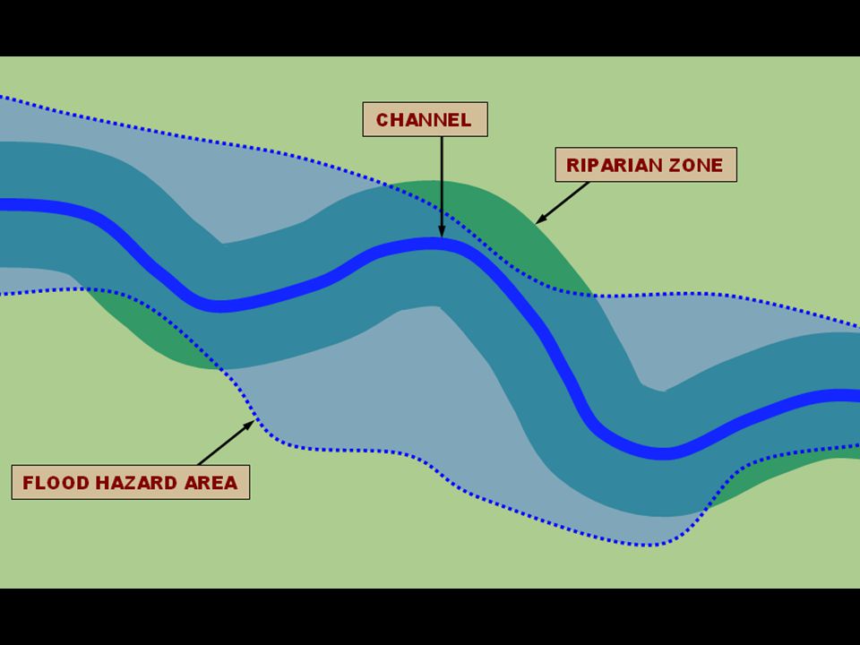
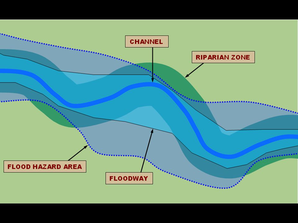
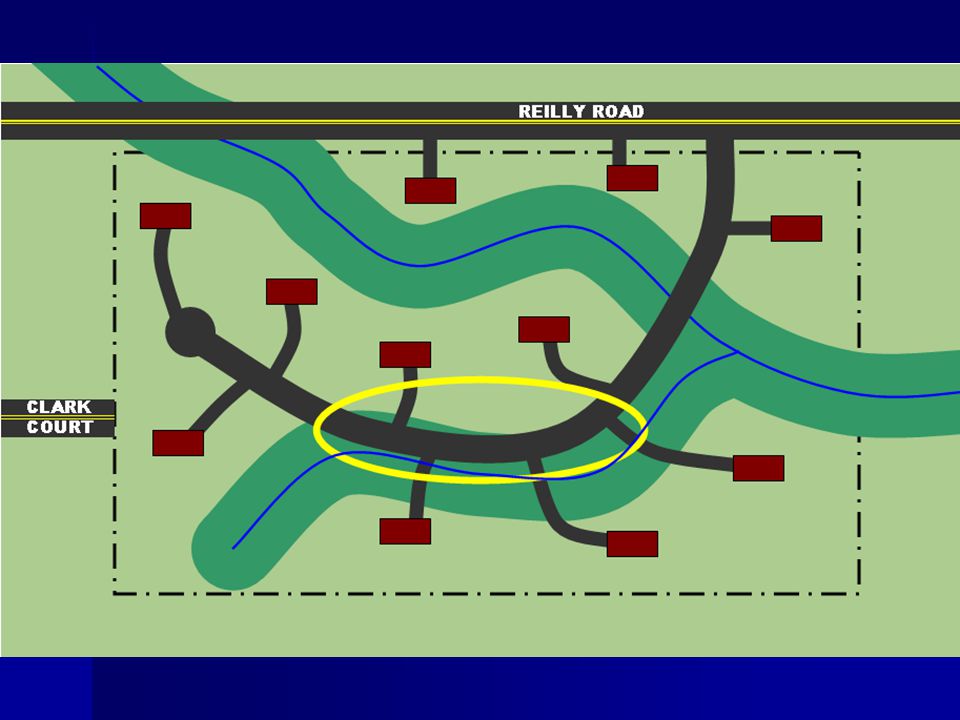
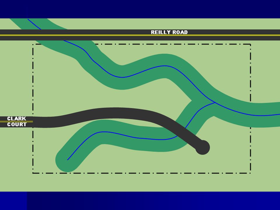
Step 2: Regulated Areas Along regulated waters there are two distinct and overlapping areas of jurisdiction: 1. The flood hazard area 2. The riparian zone

17
Flood Hazard Area A flood hazard area exists along every regulated water that has a drainage area of 50 acres or more SEE N.J.A.C. 7:13-2.3(a)1
1.")
18
Riparian Zone A riparian zone exists along every regulated water, except there is no riparian zone along: The Atlantic Ocean Any manmade lagoon or stormwater management basin Any oceanfront barrier island, spit or peninsula Any piped section of an otherwise regulated water SEE N.J.A.C. 7:13-2.3(a)2
2.")
23
Flood Hazard Area

24
Flood Hazard Area Approximately 35% of New Jersey lies in a flood hazard area

25
Flood Hazard Area The flood hazard area is comprised of the floodway and flood fringe

27
Flood Hazard Area Area inundated by the flood hazard area design flood
In tidal areas: equal to 100-yr (1%) flood In fluvial areas: equal to 100-yr (1%) flood plus a factor of safety Previous rules required assumption of full development of upstream watershed New rules add different factors of safety depending on the mapping resources available
 flood. In fluvial areas: equal to 100-yr (1%) flood plus a factor of safety. Previous rules required assumption of full development of upstream watershed. New rules add different factors of safety depending on the mapping resources available.")
28
Floodway Conveys the majority of floodwater
Structures & other materials can obstruct flow and increase flooding Calculated using a 0.2-ft rise in the 100-year flood elevation

29
Floodway

30
Floodway

32
Flood Fringe The portion of the flood hazard area outside the floodway
Waters are less deep and move slower than in floodway Structures, fill and other material can displace flood storage volume and increase flooding

34
Flood Hazard Area THERE ARE 6 METHODS FOR DETERMINING THE FLOOD HAZARD AREA Method 1 (Department delineation method) Method 2 (FEMA tidal method) Method 3 (FEMA fluvial method) Method 4 (FEMA hydraulic method) Method 5 (Approximation method) Method 6 (Calculation method) SEE N.J.A.C. 7:13-3
 Method 3 (FEMA fluvial method) Method 4 (FEMA hydraulic method) Method 5 (Approximation method) Method 6 (Calculation method) SEE N.J.A.C. 7:13-3.")
35
Riparian Zone Measures 50, 150 or 300 ft from a regulated water (previously 25 or 50 ft)
")
36
Riparian Zone 300 ft along: Category One waters and upstream tributaries within the same HUC-14 watershed Category One waters are listed in the Department’s Surface Water Quality Standards at N.J.A.C. 7:9B Not exactly the same as the Special Water Resource Protection Area SEE N.J.A.C. 7:13-4.1

37
300-ft Riparian Zone Difference #1: The SWRPA applies only to waters that are shown on a USGS quad or County Soil Survey The riparian zone applies to regulated waters regardless of any mapping SEE N.J.A.C. 7:13-4.1

38
300-ft Riparian Zone Difference #2: The SWRPA applies only to projects that are major developments The riparian zone applies to regulated waters regardless of the size of the project SEE N.J.A.C. 7:13-4.1

39
150-ft Riparian Zone Trout production waters and all tributaries
Trout maintenance waters and all tributaries within one mile Waters that flow through an area that contains documented T&E habitat (if plant/animal is critically dependent on the regulated water for survival) and all tributaries within one mile Waters that flow through an area that contains acid producing soils SEE N.J.A.C. 7:13-4.1
 and all tributaries within one mile. Waters that flow through an area that contains acid producing soils. SEE N.J.A.C. 7:")
40
50-ft Riparian Zone Along all other waters
Most common riparian zone width, especially in urbanized areas (except where acid producing soils exist) SEE N.J.A.C. 7:13-4.1
 SEE N.J.A.C. 7:")
41
Riparian Zone If a bank is present

42
If a discernible bank is NOT present: Along a linear fluvial or tidal water, such as a stream, the riparian zone is measured landward of the feature's centerline

43
If a discernible bank is NOT present: Along a non-linear fluvial water, such as a lake or pond, the riparian zone is measured landward of the normal water surface limit

44
If a discernible bank is NOT present: Along a non-linear tidal water, such as a bay or inlet, the riparian zone is measured landward of the mean high water

45
If a discernible bank is NOT present: Along an amorphously-shaped feature, such as a wetland complex, through which a regulated water flows but which lacks a discernible channel, the riparian zone is measured landward of the feature's centerline

49
Step 3: Jurisdiction THREE STEPS
Determine if you are along a regulated water Determine if you are within a regulated area along this water Determine if you are proposing a regulated activity

50
Regulated Activities 1. The alteration of topography through excavation, grading and/or placement of fill; 2. The clearing, cutting and/or removal of vegetation in a riparian zone; 3. The creation of impervious surface; 4. The storage of unsecured material; 5. The construction, reconstruction and/or enlargement of a structure; and 6. The conversion of a building into a private residence or a public building. SEE N.J.A.C. 7:13-2.4(a)
")
51
Permit Requirement Before undertaking a regulated activity in a regulated area, you must first obtain one of the following for the work: A permit-by-rule (N.J.A.C. 7:13-7) A general permit (N.J.A.C. 7:13-8) An individual permit (N.J.A.C. 7:13-9,10 & 11) An emergency permit (N.J.A.C. 7:13-12) A coastal permit (N.J.A.C. 7:7 and 7:7E) SEE N.J.A.C. 7:13-2.1(b)
 A general permit (N.J.A.C. 7:13-8) An individual permit (N.J.A.C. 7:13-9,10 & 11) An emergency permit (N.J.A.C. 7:13-12) A coastal permit (N.J.A.C. 7:7 and 7:7E) SEE N.J.A.C. 7:13-2.1(b)")
52
Coastal permits Issue #1: the previous FHA rules exempted many tidal waters So, many tidal flood hazard areas in NJ were unregulated

53
Coastal permits Issue #2 the previous FHA rules also exempted projects that needed a waterfront development or CAFRA permit BUT These coastal permits applied less stringent standards for projects than the FHA rules (creating a double standard)
")
54
Coastal permits The list of exempt tidal waters was deleted so that all waters in NJ are regulated under the new FHA rules New special area created for the riparian zone in coastal zone management rules at N.J.A.C. 7:7E-3.26

55
Coastal permits Coastal rules now cross-reference the FHA rules, so that all coastal permits will need to meet all FHA standards Getting a coastal permit therefore satisfies FHA permitting requirements You will not need a separate FHA permit for the same activity

57
Permit Requirement Before undertaking a regulated activity in a regulated area, you must first obtain one of the following for the work: A permit-by-rule (N.J.A.C. 7:13-7) A general permit (N.J.A.C. 7:13-8) An individual permit (N.J.A.C. 7:13-9,10 & 11) An emergency permit (N.J.A.C. 7:13-12) A coastal permit (N.J.A.C. 7:7 and 7:7E) SEE N.J.A.C. 7:13-2.1(b)
 A general permit (N.J.A.C. 7:13-8) An individual permit (N.J.A.C. 7:13-9,10 & 11) An emergency permit (N.J.A.C. 7:13-12) A coastal permit (N.J.A.C. 7:7 and 7:7E) SEE N.J.A.C. 7:13-2.1(b)")
58
Applicability Determination N.J.A.C. 7:13-5.1
Free application to NJDEP to verify whether a permit is needed for a particular activity Called a “jurisdictional determination” under previous rules

59
Applicability Determination N.J.A.C. 7:13-5.1
Sometimes the exact limits of the flood hazard area and riparian zone must be known before NJDEP can determine whether an activity requires a permit In such cases, applicants may need to obtain a verification first before NJDEP can issue an applicability determination

60
Verification N.J.A.C. 7:13-6.1 Application to NJDEP to verify the extent of a flood hazard area and riparian zone on a given site Similar to a freshwater wetlands letter of interpretation Separate from a permit application (can be obtained with a permit or prior to a permit)
")
61
Verification N.J.A.C. 7:13-6.1 90-day review
In most cases, a verification is needed before NJDEP can issue an individual permit (except as noted at 7:13-9.6) No more stream encroachment lines: we now establish flood hazard area, floodway and riparian zone limits
 No more stream encroachment lines: we now establish flood hazard area, floodway and riparian zone limits.")
62
Permits-by-rule N.J.A.C. 7:13-7
Projects that NJDEP has determined will cause no adverse impacts to flooding or the environment if undertaken correctly Minor repair and maintenance activities Activities associated with an existing home or business Other minor construction activities

63
Permits-by-rule N.J.A.C. 7:13-7
No application necessary The permit is automatically granted by the rules if certain conditions are met However, eight of them require prior notification via mail or so NJDEP can inspect work (see N.J.A.C. 7:13-7.2(a))
)")
64
General permits N.J.A.C. 7:13-8
Minor repair and maintenance activities by local governments (sediment removal, bridge scour protection, etc.) Agricultural activities under NRCS oversight Minor construction activities along waters that drain less than 50 acres
 Agricultural activities under NRCS oversight. Minor construction activities along waters that drain less than 50 acres.")
65
General permits N.J.A.C. 7:13-8
Simplified application $500 application fee No noticing requirements 45-day review (except GP1) Note: GP1 and GP6 are free
 Note: GP1 and GP6 are free.")
66
Individual permits N.J.A.C. 7:13-9, 10 and 11
For all activities not covered by a permit-by-rule or general permit Most applications under the new rules will be individual permits (unlike freshwater wetlands and coastal permit programs)
")
67
Individual permits N.J.A.C. 7:13-9, 10 and 11
Hardship exceptions – for projects where strict compliance would create a hardship – N.J.A.C. 7:13-9.8 Provisions are nearly identical to previous rules.

68
Individual permits N.J.A.C. 7:13-9, 10 and 11
Application review standards and general conditions in sub 9 Area-specific standards in sub 10 Based on where a project is located (channel, flood fringe, riparian zone, etc.) Activity-specific standards in sub 11 Based on the type of project (bridge, building, road, bank stabilization, etc.)
 Activity-specific standards in sub 11. Based on the type of project (bridge, building, road, bank stabilization, etc.)")
69
Area-Specific Standards N.J.A.C. 7:13-10
10.1 – Channel 10.2 – Riparian zone 10.3 – Floodway 10.4 – Flood fringe 10.5 – Fishery resources 10.6 – T&E species 10.7 – Acid producing soils

74
Project-Specific Standards N.J.A.C. 7:13-11
11.1 – General standards 11.2 – Stormwater management 11.3 – Excavation, fill & grading 11.4 – Structures 11.5 – Buildings 11.6 – Railroads, roads & parking

75
Project-Specific Standards N.J.A.C. 7:13-11
11.7 – Bridges & culverts 11.8 – Footbridges 11.9 – Utility lines 11.10 – Stormwater outfalls 11.11 – Dams & low dams 11.12 – Flood control projects

76
Project-Specific Standards N.J.A.C. 7:13-11
11.13 – Retaining walls & bulkheads 11.14 – Bank stabilization 11.15 – Sediment removal 11.16 – Storing unsecured material 11.17 – Hazardous substances 11.18 – Solid waste 11.19 – Removing fill & structures

86
Riparian Zone Disturbance N.J.A.C. 7:13-10.2
What if I need to conduct regulated activities in the riparian zone?

87
Riparian Zone Disturbance N.J.A.C. 7:13-10.2
Not a prohibition on construction Disturbance must be justified Each activity has limits on disturbance Designed to preserve vegetation Redevelopment of lawfully non-vegetated areas is not hindered, except that it should be pulled back at least 25 feet from bank where possible

88
Riparian Zone Disturbance N.J.A.C. 7:13-10.2(c)
All temporary and permanent disturbance to vegetation in the riparian zone counts All vegetation counts (trees, grass, weeds, etc.)
")
89
Riparian Zone Disturbance N.J.A.C. 7:13-10.2(d)
All work must meet 3 basic criteria: 1. The basic purpose of the project cannot be accomplished onsite without disturbing vegetation in the riparian zone;

90
Riparian Zone Disturbance N.J.A.C. 7:13-10.2(d)
2. Disturbance to the riparian zone is eliminated where possible; where not possible to eliminate, disturbance is minimized through methods including relocating the project, reducing the size or scope of the project and/or situating the project in portions of the riparian zone where previous development or disturbance has occurred;

91
Riparian Zone Disturbance N.J.A.C. 7:13-10.2(d)
3. All temporarily cleared, cut or removed vegetation within a riparian zone is replanted with indigenous, non-invasive vegetation upon completion of the project. Plus, additional criteria must be met for each specific activity in 10.2(e) through (r)
 through (r)")
93
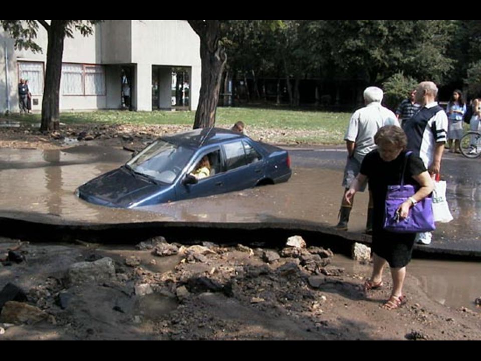
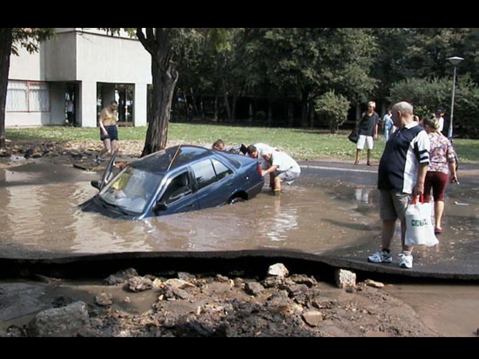
Example

94
Example

95
Example

96
Example

97
Example

98
Example

99
Example

100
Example: N.J.A.C. 7: (f) (f) The Department shall issue an individual permit for the expansion or improvement of a lawfully existing railroad or public roadway, which results in clearing, cutting and/or removing vegetation in a riparian zone, only if the following requirements are satisfied:
 The Department shall issue an individual permit for the expansion or improvement of a lawfully existing railroad or public roadway, which results in clearing, cutting and/or removing vegetation in a riparian zone, only if the following requirements are satisfied:")
101
Example: N.J.A.C. 7: (f) 1. The total area of vegetation cleared, cut and/or removed within the riparian zone does not exceed the limits set forth in Table C above, unless the applicant demonstrates that public safety cannot be adequately ensured without exceeding these limits. In such a case, the applicant shall provide 2:1 compensation for all cleared, cut and removed vegetation in excess of the limit set forth in Table C in a manner described at (t) below;
 below;")
102
Example: N.J.A.C. 7: (f) 2. The width of the railroad or public roadway is minimized; and 3. If the project impacts a 150-foot or 300-foot riparian zone, the applicant demonstrates that there is a compelling public need to expand or improve the railroad or public roadway, which cannot be satisfied without impacting the riparian zone. This demonstration shall include an analysis of alternate routes and other alternative projects that would avoid impacting the riparian zone.

103
2:1 Compensation: N.J.A.C. 7:13-10.2(t)
Allowed in certain cases for: Necessary improvements to existing public roadway or railroads (f) Bank stabilization and channel restoration – 10.2(i) Flood control projects (o) Other small projects – 10.2(r) Hardship waivers – 10.2(s)
 Bank stabilization and channel restoration – 10.2(i) Flood control projects (o) Other small projects – 10.2(r) Hardship waivers – 10.2(s)")
104
2:1 Compensation: N.J.A.C. 7:13-10.2(t)
Can be accomplished in two ways: Removing lawfully existing structures and/or impervious surfaces in the riparian zone, and replanting the area with vegetation, or Planting new trees in the riparian zone in an area that is substantially devoid of trees at the time of application because the trees were removed due to previous, lawful development.

115
FLOOD STORAGE DISPLACEMENT (A.K.A. NET-FILL) N.J.A.C. 7:13-10.4
Old rules: 0% net-fill in Central Passaic Basin 0% net-fill in Highlands Preservation Area 20% net-fill outside these areas New rules: 0% net-fill Statewide Note: net-fill only applies in non-tidal areas

116
FLOOD STORAGE DISPLACEMENT (A.K.A. NET-FILL) N.J.A.C. 7:13-10.4
Redevelopment You get credit for structures and fill you remove from flood fringe Replacing a building with a new one may result in little or no new flood storage displacement

117
FLOOD STORAGE DISPLACEMENT (A.K.A. NET-FILL) N.J.A.C. 7:13-10.4
Up to 20% net-fill allowed onsite provided all fill is compensated by an equal cut in same floodplain offsite Compensatory flood storage cannot: Be in a floodway Be separated from the fill by a water control structure (bridge, dam, etc.) in most cases Be in an undisturbed riparian zone, SWRPA or Highlands Preservation Area buffer Be in a different HUC14 watershed as the fill Cause significant adverse environmental consequences
 in most cases. Be in an undisturbed riparian zone, SWRPA or Highlands Preservation Area buffer. Be in a different HUC14 watershed as the fill. Cause significant adverse environmental consequences.")
118
FLOOD STORAGE DISPLACEMENT
Certain activities are exempt - see 10.4(d): Any activity in a tidal flood hazard area Any activity that displaces no more than 5 cubic yards of flood storage volume The reconstruction of a lawfully existing railroad or public roadway, including any improvement or enlargement, provided flood storage volume displacement is minimized The construction or improvement of a driveway across a regulated water (in certain cases) The construction of one private residence (in certain cases) The construction of a flood control project, provided flood storage volume displacement is minimized The deposition of sediment removed from a channel
: Any activity in a tidal flood hazard area. Any activity that displaces no more than 5 cubic yards of flood storage volume. The reconstruction of a lawfully existing railroad or public roadway, including any improvement or enlargement, provided flood storage volume displacement is minimized. The construction or improvement of a driveway across a regulated water (in certain cases) The construction of one private residence (in certain cases) The construction of a flood control project, provided flood storage volume displacement is minimized. The deposition of sediment removed from a channel.")
119
FLOOD STORAGE DISPLACEMENT
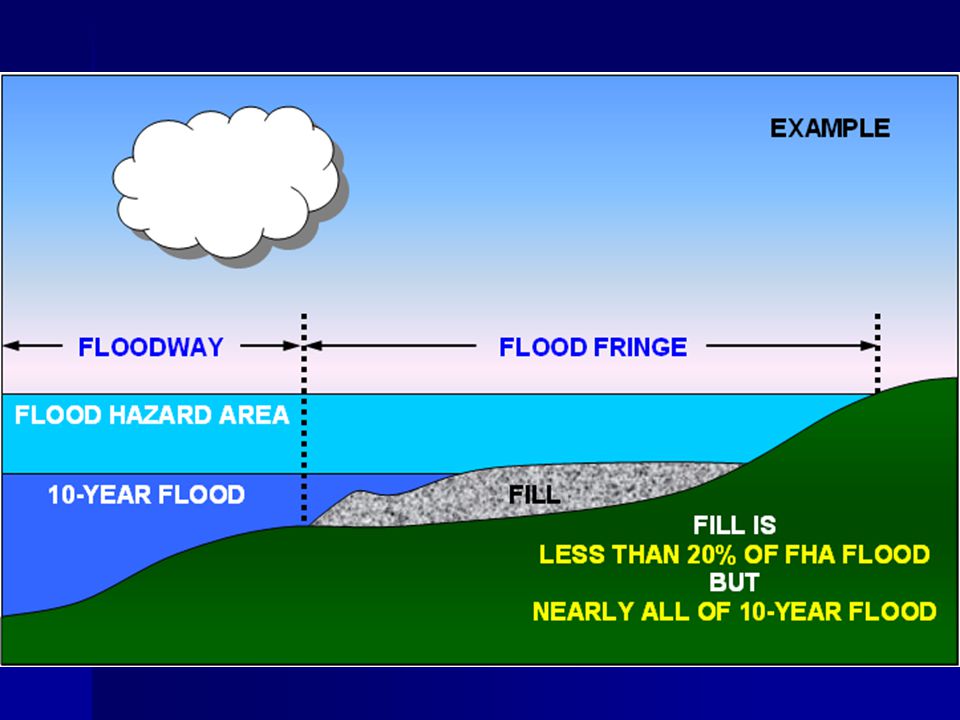
0% NET-FILL STANDARD APPLIES TO BOTH: The space between the flood hazard area design flood and the 10-year flood AND The space between the 10-year flood and the ground

122
IF10-YEAR FLOOD IS UNKNOWN:
If NJDEP or FEMA mapping does not provide the 10-year flood elevation, you can: Calculate the 10-year flood elevation OR Use a flood depth halfway between the flood hazard area design flood elevation and the lowest ground elevation within the flood fringe onsite (at each given cross-section).
.")
124
Elevating structures N.J.A.C. 7:13-11.5
Lowest habitable floor of buildings must be constructed at least 1 foot above the flood hazard area design flood elevation Note: when FEMA maps are used, the flood hazard area design flood is 1 foot above the FEMA 100-year flood in non-tidal areas. So lowest floor must be constructed 2 feet above FEMA 100-year elevation.

125
Elevating structures N.J.A.C. 7:13-11.5

126
Elevating structures N.J.A.C. 7:13-11.5

127
Elevating structures N.J.A.C. 7:13-11.5

128
Elevating structures N.J.A.C. 7:13-11.5

129
Elevating structures N.J.A.C. 7:13-11.5

130
Elevating structures N.J.A.C. 7:13-11.5
Open area beneath a structure must be: A garage under 625 square feet in footprint OR A crawl space that is not more than 6 feet in height measured from floor to floor If the above is not possible, then at least 25% of the exterior walls of the enclosed area must remain permanently open

132
Other approvals N.J.A.C. 7:13-12, 13 and 14
Emergency permit (N.J.A.C. 7:13-12) Revision to a verification, general permit, individual permit or a State adopted flood study (N.J.A.C. 7:13-13) Transfer of an approval to another owner (N.J.A.C. 7:13-14)
 Revision to a verification, general permit, individual permit or a State adopted flood study (N.J.A.C. 7:13-13) Transfer of an approval to another owner (N.J.A.C. 7:13-14)")
133
Final thoughts… N.J.A.C. 7:13-15-19
Sub 15 – Application requirements Sub 16 – Public notice Sub 17 – Fees Sub 18 – Adjudicatory hearings Sub 19 – Enforcement

134
Any Questions? For more information contact: Vince Mazzei, PE
NJDEP Division of Land Use Regulation PO Box 439 Trenton, NJ 08625 Phone: (609) Website:
 Website:")
Similar presentations


 Regulations Fulton County Conservation District 216 N. Second Street, Suite 15.>")

 Nontidal Wetland Waterway.>")


 –Administered by Coastal Programs Division of NOAA –Covers over 22% of U.S. Land Area –Multi-purpose.>")

