Download presentation
Presentation is loading. Please wait.

1
Surveying Chain Surveying
Faculty of Applied Engineering and Urban Planning Civil Engineering Department Surveying 2nd Semester 2007/2008 Chain Surveying

2
Types of Distance Measurement Measurement Methods
Contents Types of Distance Measurement Measurement Methods Direct (tapes) Indirect: (EDM, Stadia) Errors and Corrections for Tape Measurement EDM
 Indirect: (EDM, Stadia) Errors and Corrections for Tape Measurement. EDM.")
3
Introduction One of the fundamentals of surveying is the need to measure distance. Distances are not necessarily linear, especially if they occur on the spherical earth. In the present subject we will deal with distances in Euclidean (geometric) space, which we can consider a straight line from one point or feature to another.
 space, which we can consider a straight line from one point or feature to another.")
4
Common Methods for Measuring Distances
Pacing Taping Tachometry (required theodolite, and graduated rod) EDM (Electronic Distance Measurement)
 EDM (Electronic Distance Measurement)")
5
Equipment Used in Chain Surveying
Measurement of Lines Chain Tapes Invar Tapes (more accurate, 65% steel, 35 Nicke) Making Right Angles Optical Prism Others Ranging Rods Arrows Pegs Plumb bobs
 Making Right Angles. Optical Prism. Others. Ranging Rods. Arrows. Pegs. Plumb bobs.")
6
Types of Distance Measurement

7
Types of Distance Measurement

8
Types of Distance Measurement

9
Examples: When use which
1. If you are intending to draw a map or area, horizontal distance and height difference (vertical distance) should be used to enable plan and height information to be drawn. 2. If you are to locate points such as a corner of a building or centre line of a road, slope distance and vertical distance are required to enable pigs be located at correct points on site (Layinging Out).
 should be used to enable plan and height information to be drawn. 2. If you are to locate points such as a corner of a building or centre line of a road, slope distance and vertical distance are required to enable pigs be located at correct points on site (Layinging Out).")
10
Methods of Measurement
Pacing Accuracy 1 : 100 Taping Accuracy 1 : 10,000 Electronic Distance Measurement (EDM) Accuracy 1 : 10,000 to 1:100,000
 Accuracy 1 : 10,000 to 1:100,000.")
11
Pacing Practical measure of distance.
Don't try to pace out one meter with every step. Walk casually over 100 m counting the number of steps. Work out the length of a casual step and use this instead. Varies with uphill, downhill, and your age. Low accuracy No equipment needed

12
Taping (or chaining) Chaining is applied to measurement with a steel tape or synthetic tape (plastic or fiberglass). All standard in lengths 100 m, 50m, 30 m, 20 m. It is fairly quick, easy and cheap, and hence is the most common form of distance measurement. Unfortunately, Chaining is prone to errors and mistakes. For high accuracy, steel tape should be used which is graduated in mm and calibrated under standard temp (20 degree) and tension (5kg). Be careful, easily break. Synthetic tape is more flexible graduated in 10mm
 and tension (5kg). Be careful, easily break. Synthetic tape is more flexible graduated in 10mm.")
13
Equipment Used in Chain Surveying

15
Some Taping Instruments
Measuring wheels Tapes in lengths up to 100 ft

16
Taping Procedures ranging rods set up between points A and B
from A to B, set zero of tape at A tape unwound towards B A third range rod is “ranged” in at C Tape straightened, held tight and read at rod C C marked with a pin for next bay, tape moved from A and zero set at C and so on

17
Accessories

18
Processes in Chain Surveying
Ranging and Measurement of Lines Level Ground Uniformly Sloping Ground Uneven Ground

19
Level Ground Rod Rod A A1 A2 A3 A4 B

20
Stationing Along Baseline: stations At right angle: offset dist. 0+00
2+50 4+96

21
21

22
Length AB = 4 x Full tape distance + 1 Short section
22 Length AB = 4 x Full tape distance + 1 Short section REMEMBER ! It works only on smooth ground or uniform slope surfaces

23
Example 23

24
Example How about this very uneven case or high accuracy is required?
24

25
Example Sag curve Sag curve measurement is not common nowadays and is restricted to steel tape only. 25

26
Processes in Chain Surveying

27
Uniformly Sloping Ground

28
Uneven Ground

30
In Previous Ranging and Measurement of Lines Level Ground
Uniformly Sloping Ground Clinometers Abney Level Uneven Ground

31
Homework Solve Problems: 1.5, 1.6, 1.7 2.1, 2.2, 2.5

32
Lecture 5

33
Setting Out Right Angles
Method 1 Extend tape horizontally, swing it left and right , observe min. Reading This method is primarily used on smooth ground where a free swing of tape is possible. C A B

34
Setting Out Right Angles
Method 2 With free end of tape, strike an arc to cross the line AB at points D & E. bisect DE at F. Then angle CFE=90 C F A B D E

35
Setting Out Right Angles
Method 3 Run tape from C to D, bisect CD, with E as center and radius equal to ED, strike an arc to cross line AB at F, then DFC=90 C E D B F A

36
Setting Out Right Angles
Method 4 Using optical square with double prism Prove Method 4 provided in the text book

37
Setting Out a Line at Right Angles
Method 1

38
Setting Out a Line at Right Angles
Method 2

39
Setting Out a Line at Right Angles
Method 3 5 m 3 m 4 m

40
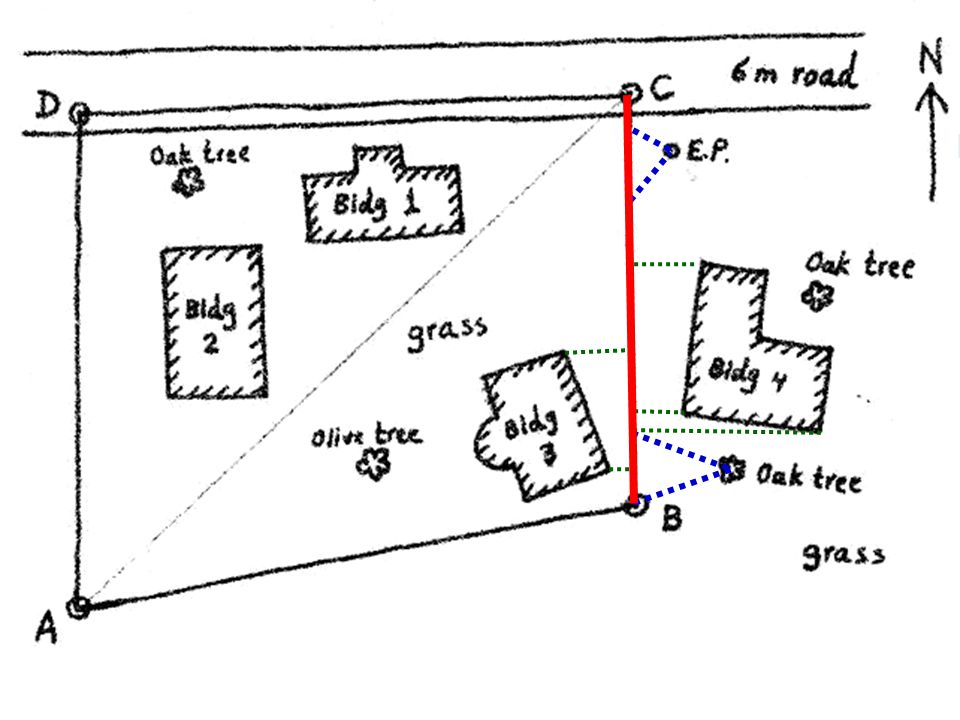
Mapping Details Methods of Locating Ground Details Method of Ties:
a point is located by measuring two reasonable distance called ties between this point and two points on the chain line (a) Method of Offsets : a point is projected on he chain line and then the distance between the points and its projection (called offset) as well as the distance from the beginning point of the line to the projected point are measured. (b)
 Method of Offsets : a point is projected on he chain line and then the distance between the points and its projection (called offset) as well as the distance from the beginning point of the line to the projected point are measured. (b)")
43
Choice of Chain Lines Well conditioned triangles (Angles 30 – 120)
")
44
Choice of Chain Lines As close as possible to the buildings

45
Choice of Chain Lines At least two stations can be seen

46
Choice of Chain Lines Minimum Number of Lines

47
Choice of Chain Lines Provide check line possibility

48
Choice of Chain Lines Avoid obstacles

49
Booking Details

50
Begin with fresh page All measurement should be recorded Proceed with booking from the bottom of the page to the top, the records should be recorded in the direction of chaining All details must be sketched neatly and roughly to scale All other chain lines which meet the chain line being measured should be recorded in appropriate place

52
Plotting the details

53
Booking the Measurements

Similar presentations


 = the length of the path travelled by light in vacuum during a specific fraction of a second (1/299 792.>")


