Download presentation
Presentation is loading. Please wait.

1
Mapping Current Vegetation in the Pacific Coast States with GNN, CART, and Other Tricks Landscape Ecology, Modeling, Mapping, and Analysis (LEMMA) team (www.fsl.orst.edu/lemma) Janet Ohmann 1, Ken Pierce 1, Emilie Grossmann 2, Matt Gregory 2, Heather May 2, Tim Holt 2 Collaborators: Jeremy Fried 3, Jimmy Kagan 4, Ken Brewer 5, Miles Hemstrom 6, Melinda Moeur 7, Tom DeMeo 7, Gary Lettman 8, Mike Wimberly 9 1 USDA FS, PNW, Ecosystem Processes; 2 Oregon State University, Forest Science Department; 3 USDA FS, PNW, Forest Inventory and Analysis; 4 Oregon State University, Institute of Natural Resources; 5 USDA FS, Remote Sensing and Applications Center; 6 USDA FS, PNW, Focused Science Delivery; 7 USDA FS, Region 6; 8 Oregon Department of Forestry; 9 South Dakota State University
 team ( Janet Ohmann 1, Ken Pierce 1, Emilie Grossmann 2, Matt Gregory 2, Heather May 2, Tim Holt 2 Collaborators: Jeremy Fried 3, Jimmy Kagan 4, Ken Brewer 5, Miles Hemstrom 6, Melinda Moeur 7, Tom DeMeo 7, Gary Lettman 8, Mike Wimberly 9 1 USDA FS, PNW, Ecosystem Processes; 2 Oregon State University, Forest Science Department; 3 USDA FS, PNW, Forest Inventory and Analysis; 4 Oregon State University, Institute of Natural Resources; 5 USDA FS, Remote Sensing and Applications Center; 6 USDA FS, PNW, Focused Science Delivery; 7 USDA FS, Region 6; 8 Oregon Department of Forestry; 9 South Dakota State University")
2
COLA CLAMS, GNNfire GNNFire Vegetation mapping projects Analysis of forest policy effects via landscape modeling and scenario analysis: CLAMS, COLA, IMAP, NWFP, etc. Land management planning (NF Plans, BLM Cumulative Effects, etc.) Biodiversity assessment and conservation planning (GAP) Regional risk assessment, fuels/fire (WWETAC, GNNFire) IMAP timeline: –E. OR Cascades by 10/06 –W. OR by 5/07 –rest of NWFP area (WA, CA?) by 10/08 GAP timeline: –All ecoregions by 12/07 IMAP, GAP (colored regions)
 Biodiversity assessment and conservation planning (GAP) Regional risk assessment, fuels/fire (WWETAC, GNNFire) IMAP timeline: –E. OR Cascades by 10/06 –W. OR by 5/07 –rest of NWFP area (WA, CA ) by 10/08 GAP timeline: –All ecoregions by 12/07 IMAP, GAP (colored regions).")
3
Gradient Nearest Neighbor Method Plot data Climate Geology Topography Ownership Remote sensing PredictionSpatial data Plot locations Direct gradient analysis (CCA) Plot assigned to each pixel Statistical model Imputation Pixel PSME (m 2 /ha) CanCov (%) Snags >50 cm (trees/ha) Old-growth index Etc... 11137.40.27... 279972.10.82...

4
Forest Plots: Eastern Oregon Cascades – South 1 234 56 7* 89 101112 13 Plot layout (~1 ha) Vegetation data: Live trees Snags Down wood Understory vegetation
 Vegetation data: Live trees Snags Down wood Understory vegetation")
5
LandsatBands, transformations, texture ClimateMeans, seasonal variability TopographyElevation, slope, aspect, solar DisturbancePast fires, harvest, I&D LocationX, Y Ownership Federal, state, forest industry, other private Eastern Washington Coastal Oregon Explanatory Variables

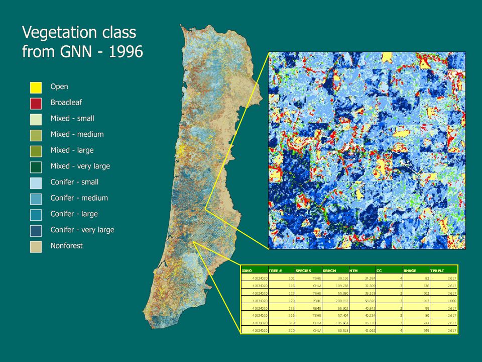
7
2001 NLCDDOQCoyote area

8
GNN model specification Species Species + structure Structure Image segments (polygons), watersheds (imagery not used) Median-filtered√√ Unfiltered√√ Coarse grain Fine grain Model response variables Spatial grain of Landsat variables Emphasis on species composition Emphasis on forest structure ‘Tuning’ of GNN models
, watersheds (imagery not used) Median-filtered√√ Unfiltered√√ Coarse grain Fine grain Model response variables Spatial grain of Landsat variables Emphasis on species composition Emphasis on forest structure ‘Tuning’ of GNN models")
9
Goal: develop a map of current vegetation to support landscape modeling and analysis - Gradient Nearest Neighbor Method Satellite imagery GIS data Landscape vegetation map Fuel models, wildlife models, etc. Fuel maps Field plots Predicted future landscapes Stand and landscape simulators (FVS-FFE, VDDT, TELSA, etc.) Fire behavior models (FARSITE, FLAMMAP) Fire effects models (FOFEM, CONSUME) Habitat maps Etc.
 Fire behavior models (FARSITE, FLAMMAP) Fire effects models (FOFEM, CONSUME) Habitat maps Etc..")
10
Ecological Systems: A new level of landcover classification. Within the National Vegetation Classification: –Vegetation Class (Subcontinental Scale) Vegetation Formation (Regional Scale) –Ecological Systems (10ha – 10,000ha) »Plant Association (Local Scale) Aggregations of Plant Associations, based on –Floristics –Successional sequences (stable: 50 – 100 yr time-frame) –Geology/Climate/Disturbance regime ~ potential vegetation on a fairly short time-frame Website:http://www.natureserve.org/explorer/
 Vegetation Formation (Regional Scale) –Ecological Systems (10ha – 10,000ha) »Plant Association (Local Scale) Aggregations of Plant Associations, based on –Floristics –Successional sequences (stable: 50 – 100 yr time-frame) –Geology/Climate/Disturbance regime ~ potential vegetation on a fairly short time-frame Website:")
11
Some Likely Ecological Systems within the Winnema-Fremont NF Mediterranean California Red Fir Forest Mediterranean California Mesic Mixed Conifer Forest and Woodland Rocky Mountain Poor Site Lodgepole Pine Forest Northern Rocky Mountain Ponderosa Pine Woodland and Savanna

12
Northern Rocky Mountain Ponderosa Pine Woodland and Savanna Abridged Description: … These woodlands and savannas occur at the lower treeline/ecotone between grasslands or shrublands and more mesic coniferous forests typically in warm, dry, exposed sites. Elevations range from less than 500 m in British Columbia to 1600 m…. This ecological system generally occurs on glacial till, glacio-fluvial sand and gravel, …, with characteristic features of good aeration and drainage, … and periods of drought during the growing season. Pinus ponderosa (primarily var. ponderosa) is the predominant conifer; Pseudotsuga menziesii may be present in the tree canopy but is usually absent. The understory can be shrubby, with Artemisia tridentata, Arctostaphylos patula, …, Amelanchier alnifolia, and Rosa spp. common species. Mixed fire regimes and ground fires of variable return intervals maintain these woodlands …. Historically, many of these woodlands and savannas lacked the shrub component as a result of 3- to 7-year fire-return intervals.
 is the predominant conifer; Pseudotsuga menziesii may be present in the tree canopy but is usually absent. The understory can be shrubby, with Artemisia tridentata, Arctostaphylos patula, …, Amelanchier alnifolia, and Rosa spp. common species. Mixed fire regimes and ground fires of variable return intervals maintain these woodlands …. Historically, many of these woodlands and savannas lacked the shrub component as a result of 3- to 7-year fire-return intervals..")
13
Forested Ecological Systems of the Blue Mountains Ecoregion, Eastern Oregon Coming for Winnema-Fremont NF: Nonforest Details too!

Similar presentations


 project update and discussion.>")


>")


: Challenges, results and recommendations from the western United States Matt Gregory 1, Emilie Grossmann.>")

>")


