Download presentation
Presentation is loading. Please wait.

1
Division of Agricultural Meteorology India Meteorological Department
Consideration of the Recommendations of the Expert Team Meeting on Reducing the Impact of Natural Disaster and Mitigation of Extreme Events by H. P. Das Division of Agricultural Meteorology India Meteorological Department

2
Current definitions of natural disasters are primarily meant to address socio-economic management issues related to natural disasters. It is important to develop a more comprehensive definition of natural disasters for applications in agriculture, rangelands, forestry, and fishery sectors.

3
Comprehensive definition of natural disasters
Drought Rainfall deficiency Intensity 26 to 50% Moderate drought 51% and above Severe drought The extent of drought for India as a whole may described as Description Area affected Moderate scale to 30 % Large scale to 40 % Mega scale More than 40 % Drought year for the country as a whole will be the year when all India rainfall deficiency exceeding 10% and covering more than 20% of the geographical area having rainfall deficiency of 26% or more.

4
…..continued Some of the criteria to take into account agricultural drought (i) 5 mm or less rainfall for a period of 20 days or more and the mean daily sum of rain for this period not more than 0.5 mm. (ii) (a) 15 consecutive days or more with rainfall < 0.2 mm (b) 30 consecutive days or more when15 consecutive days or more mean daily rainfall does not exceed 0.2 mm (iii) Area experiencing consecutively 2 to 3 or more months with rainfall less than 75 mm for dryland crops and 200 mm for bunded rice. 40 to 50% below normal rainfall for 2 consecutive days or more. No rainfall for 20consecutive days. Fall of soil moisture below 65% of the field moisture capacity or 10 % decrease in soil moisture. Temporal distribution of the rainfall below 50% of the normal. (viii) A period of insufficient rain during which the soil moisture is totally consumed by the plants (based on reports).
 5 mm or less rainfall for a period of 20 days or more and the mean daily sum of rain for this period not more than 0.5 mm. (ii) (a) 15 consecutive days or more with rainfall < 0.2 mm. (b) 30 consecutive days or more when15 consecutive days or more mean daily rainfall does not exceed 0.2 mm. (iii) Area experiencing consecutively 2 to 3 or more months with rainfall less than 75 mm for dryland crops and 200 mm for bunded rice. 40 to 50% below normal rainfall for 2 consecutive days or more. No rainfall for 20consecutive days. Fall of soil moisture below 65% of the field moisture capacity or 10 % decrease in soil moisture. Temporal distribution of the rainfall below 50% of the normal. (viii) A period of insufficient rain during which the soil moisture is totally consumed by the plants (based on reports).")
5
Tropical Cyclone …..continued Range of maximum wind speeds
Region Range of maximum wind speeds (meters per second) Western North Pacific Ocean Tropical cyclone Typhoon Bay of Bengal and Arabian Sea Cyclone Severe cyclone South Indian Ocean Tropical depression Tropical Cyclone South Pacific Ocean North Atlantic Ocean and Eastern North Pacific Ocean Tropical Storm Hurricane Tsunami Magnitude : 7.5 RS Focal depth : 60 km Type of faulting: Crustling movement (vertical / horizontal)
 Western North Pacific Ocean. Tropical cyclone. Typhoon. Bay of Bengal and Arabian Sea. Cyclone. Severe cyclone. South Indian Ocean. Tropical depression. Tropical Cyclone. South Pacific Ocean. North Atlantic Ocean and Eastern North Pacific Ocean. Tropical Storm. Hurricane. Tsunami. Magnitude : 7.5 RS. Focal depth : 60 km. Type of faulting: Crustling movement (vertical / horizontal)")
6
2. Assessment of the impact of natural disasters on
2. Assessment of the impact of natural disasters on agriculture, rangelands, forestry, and fisheries requires the design of a comprehensive database in accordance with the users needs. There is a need for an integrated data management system including adequate collection, quality control, analysis and presentation of data specific to certain kinds of disaster, e.g., lightning incidence, soil moisture, and fire danger indices. Presentation should make use of best available technology, e.g., GIS and Internet.

7
Comprehensive Database
The first and the most basic requirement in agrometeorological hazard assessment for natural disasters is an adequate database. While measures to optimize a natural disaster database should be vigorously persued, it must be recognized that basic data collection processing and storage remains the corner stone of any research and operational aspects of extreme events. The database can be complied using Relational Database Management Systems (RDBMS) so that it will be possible to subject this database to queries for more informed decision-making. It is also possible to interface such an RDBMS to geographical information system (GIS) of the area, which will act as a front-end so that scenario analysis results can be stimulated to see the options on the GIS. Such systems can also support forecasting and predictive models, especially if time series data sets are available for such areas and communities.
 so that it will be possible to subject this database to queries for more informed decision-making. It is also possible to interface such an RDBMS to geographical information system (GIS) of the area, which will act as a front-end so that scenario analysis results can be stimulated to see the options on the GIS. Such systems can also support forecasting and predictive models, especially if time series data sets are available for such areas and communities.")
8
…..continued The management information system (MIS) for disaster management brings together data and information so that policy analysis and problem solving exercises can be carried out for more informed decision making. All aspects of disaster of disaster management like search and rescue, evacuation, preparedness, prevention, rehabilitation and recovery can be carried out using the MIS approach. Presentation of data also can be specific to certain kind of disasters, for example, fire danger indices, Aridity Anomaly indices, etc. There are thousands of websites on the internet, which provide information on various specialized fields of disaster management. There can be bulletin boards, chat rooms, list serves etc. with auto robots responding to specific queries.
 for disaster management brings together data and information so that policy analysis and problem solving exercises can be carried out for more informed decision making. All aspects of disaster of disaster management like search and rescue, evacuation, preparedness, prevention, rehabilitation and recovery can be carried out using the MIS approach. Presentation of data also can be specific to certain kind of disasters, for example, fire danger indices, Aridity Anomaly indices, etc. There are thousands of websites on the internet, which provide information on various specialized fields of disaster management. There can be bulletin boards, chat rooms, list serves etc. with auto robots responding to specific queries.")
9
3. Effective management of and preparedness for. natural
3. Effective management of and preparedness for natural disasters requires free and unlimited access to relevant databases that will allow monitoring, assessment, and prediction. It is recommended that all agencies responsible for these databases develop good collaborating links for the exchange of information included in these databases.

10
Access to relevant database – An example for drought
The real time monitoring and assessment of natural disaster like drought need collection of rainfall and other related data. Accumulated precipitation amount is one of the most essential parameter in a real time drought surveillance service and must supplement data on temperature, humidity, cloudiness and wind. In relation to weather hazard, data are also required of the state of crops and whether they are in such a stage of development to be particularly liable to weather hazards. It is necessary to develop good collaborating links among all agencies responsible for these database for the exchange of information and develop a strategy through which individuals and organizations known for excellence in preparedness, mitigation and disaster management can be made available to other states.

11
4. A number of modern tools and methodologies for the. monitoring
4 A number of modern tools and methodologies for the monitoring and prediction of natural disasters, such as storm surges, tropical cyclones, drought, floods, etc., are now available. Agricultural risk zoning is an essential component of natural disaster mitigation and preparedness strategies. Given the complex nature of databases, GIS and remote sensing should be employed to facilitate strategic and tactical applications at the farm and policy levels.

12
Vulnerability assessment, rich analysis and mapping
A comprehensive vulnerability analysis should be undertaken in all hazard prone areas, taking into account past disaster events, the socioeconomic conditions of the population living in the area, the infrastructure and other structural facilities for cyclones, floods, storm surges, geological hazards, etc. Risk assessment should be undertaken for all hazards, and should include areas of influence, frequency, intensity, impact, and time to return to normalcy. Hazard mapping which may give indication about agricultural risk zone can then be undertaken to delineate causative source areas and areas exposed to hazards from agricultural point of view as well as potential risk levels for different hazards. Hazard maps can therefore be deterministic or probabilistic. Valuable information on individual hazards in a study area may appear on the maps with varying scale, coverage, and other details. Information on several of them can be combined in a single map to give a composite of the magnitude, frequency and area of effect of all the hazards.

13
Example: Flood plain zoning/Flood risk zone maps
…..continued Example: Flood plain zoning/Flood risk zone maps Flood plain zoning measures aim at demarcating zones or areas likely to be affected by floods of different magnitudes or frequencies and probability levels. These maps can be effectively used for managing the flood by non-structural flood control measures. A striking irony is that flood plains often are among the most desirable of farm lands. Many of these areas have vast hectares of acquic soils that typically require drainage for productive farm use. So, future flood planning looks not only to structural solutions but also to land use planning, zoning and other solutions that encourage agricultural production in less vulnerable areas. Suitable short duration strains of paddy, and other crops which can withstand flooding for a few days have to be developed in flood plain zone. The GIS can also play a crucial role in the process of gathering and analyzing information needed for disaster management. In fact, GIS can give higher quality results than can be obtained manually, regardless of the cost involved.

14
5. Current natural disaster management is largely. crisis driven
5 Current natural disaster management is largely crisis driven. There is an urgent need for a more risk-based management approach to natural disaster planning in agriculture, rangelands, forestry, and fisheries. An effective risk management approach would include a timely and user-oriented early warning system with rapid dissemination of information to users.

15
Risk management approach- timely early warning system
In case of drought, Early warning indicators may be: Deficit rainfall Reduced supplies in surface flow channels Inadequate soil moisture Vegetation Index Short, medium and long-range weather forecast Crop yield forecast For development of early warning system, the monitoring of drought by appropriate drought indices would be essential initial input. The basic requirement for early warning system for meteorological drought is to have long range forecast at a smaller spatial and temporal scales.

16
…..continued It is also felt to include more indicators and information in monitoring drought. Some of the parameters are dry spells, very high temperature during crop growing period, critical stages of the main crops and cultural practices needed in these stages, soil moisture in the crop root zone and outbreak of crop pests and diseases. The remote sensing can also play a good role to provide information on various drought indicators (viz. rainfall, soil moisture etc.) The NDVI and other indices are found to vary with the magnitude of greenness. Moisture stress in vegetation due to continued rainfall deficiency is reflected with lowering of value of vegetation indices. Microwave sensors can provide estimate of soil moisture only in surface layers upto 10 cm thickness It is also important to transmit this information promptly via a suitable telecommunication system
 The NDVI and other indices are found to vary with the magnitude of greenness. Moisture stress in vegetation due to continued rainfall deficiency is reflected with lowering of value of vegetation indices. Microwave sensors can provide estimate of soil moisture only in surface layers upto 10 cm thickness. It is also important to transmit this information promptly via a suitable telecommunication system.")
17
…..continued Similarly the requirements for an efficient cyclone warning system are: Advance, accurate and detailed forecasts of dangerous conditions which involve: Detection of the storm Determination of the center of development Forecast of the future intensity Forecast of the future movement A rapid and dependable distribution system for the forecasts, advisories and warnings to all interested parties; and (c) Prompt and effective utilization of warnings by the government and the public. An essential element of a warning service is that there should be certainty that the warnings will reach the intended recipients promptly. The supporting communications system, including back-up facilities, should therefore be planned and implemented in full detail.
 Prompt and effective utilization of warnings by the government and the public. An essential element of a warning service is that there should be certainty that the warnings will reach the intended recipients promptly. The supporting communications system, including back-up facilities, should therefore be planned and implemented in full detail.")
18
Recognizing that early warning is an important component
Recognizing that early warning is an important component of preparedness, it is recommended that: The concept of the drought monitor map product be promoted as a tool for all drought-prone countries to better understand drought severity using multiple indicators. A white paper be developed on the methodology for preparation of a drought monitor map with recommendations for minimum, maximum, and optimum data layers needed to successfully accomplish this task and for inter-agency collaboration to accomplish this task. The feasibility of organizing joint training workshops on national and regional drought monitor products under the auspices of WMO and the NDMC be examined. Indices used in China in their agrometeorological bulletin could be effective training tools. The first of these workshops could be organized in China.

19
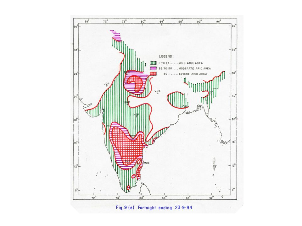
Drought monitor map India Meteorological Department (IMD) prepares aridity anomaly maps for the country as a whole in order to monitor droughts over the country on a real time basis. In addition , IMD prepares rainfall maps every week throughout the year which show rainfall received during a week and the corresponding departures from normal, thus indicating the development of drought and its termination. Another method of monitoring drought is to use standardised precipitation index (SPI) which could be adopted on operational basis in the form of map. Remote sensing can also play a good role to monitor the drought by the vegetative index map which indicates the vegetative status during the fortnight period. The NDVI and other related indices are found to carry with magnitude of green foliage brought about by phenological changes. The temporal pattern of NDVI is useful in diagnosting vegetative condition.
 prepares aridity anomaly maps for the country as a whole in order to monitor droughts over the country on a real time basis. In addition , IMD prepares rainfall maps every week throughout the year which show rainfall received during a week and the corresponding departures from normal, thus indicating the development of drought and its termination. Another method of monitoring drought is to use standardised precipitation index (SPI) which could be adopted on operational basis in the form of map. Remote sensing can also play a good role to monitor the drought by the vegetative index map which indicates the vegetative status during the fortnight period. The NDVI and other related indices are found to carry with magnitude of green foliage brought about by phenological changes. The temporal pattern of NDVI is useful in diagnosting vegetative condition.")
20
Methodology for preparation of drought map
…..continued Methodology for preparation of drought map Aridity Index = Water Deficit = Actual Evaporation – Potential Evaporation Water Need Potential Evaporation Various categories of Agricultural drought Drought Category Aridity Anomaly Value Mild Drought upto 25% Moderate Drought % Severe Drought > 50%

23
SPI classification scale SPI Value Drought Category
…..continued SPI classification scale SPI Value Drought Category 0 to Mild Drought -1.00 to – Moderate Drought -1.00 to – Severe Drought or less Extreme Drought

25
…..continued When NIR and VIS are measured radiation in near infrared and visible bands. Moisture stress in vegetation resulting from prolonged rainfall deficiency is reflected by lower NDVI values.

28
7. There is an urgent need to assess the. forecasting
7. There is an urgent need to assess the forecasting skills for natural disasters to determine those where greater research is needed. Lack of good forecast skill in drought, for example, is a constraint to improved adaptation, management, and mitigation.

29
Table 6(a) The ratio and skill score for the year 1992-2000
For the qualitative analysis of event forecast skill score and ratio score tests have been used, which are based on 2x2 contingency table. The results are as follows :- Table 6(a) The ratio and skill score for the year April 99 to March 2000) Predicted Observed Event No event Event (YY) 6 (NY) No event 10 (YN) 119 (NN)
 The ratio and skill score for the year April 99 to March 2000) Predicted Observed. Event No event. Event 12 (YY) 6 (NY) No event 10 (YN) 119 (NN)")
31
8. Given the regional and global nature of natural
8 Given the regional and global nature of natural disasters, it is essential to promote and foster the use of international and regional programs to enhance collaboration and building of partnerships and through virtual networks with distributed functions to enhance cooperation on issues related to improved management of and preparedness for natural disasters.

32
International and regional programmes for collaboration
The current policy for Disaster Management and Preparedness adopted by 176 national societies of the International Federation of Red Cross and Red Crescent includes the following salient features that compliment the strategies formulated for the International Decade for Natural Disaster Reduction. Improve co-ordination by promoting better cooperation and partnership between National Societies, the International Committee of Red Cross (ICRC), governments, non-governmental Organizations and other disaster response agencies at the local, national, regional and international levels. Raise awareness of disaster hazards through public education, encouraging vulnerable people to take preventative measures where possible before disaster strikes. Ensure that the knowledge from prediction and early warning systems can be accessed, understood and acted upon by local communities. Create activities that develop, promote and initiate harmonized training programmes and methodologies among participating states in a crisis management pact. Review the Crisis Management framework to ensure that each organization has a clearly defined role and responsibilities that match their human and material resource capacity. Now, the International Federation, along with many humanitarian organizations, perceives that the present challenge is to create more effective mitigation programmes that enable people in at-risk environments to gain mastery of their own lives and overcome the vulnerabilities that inhibit social and economic development.
, governments, non-governmental Organizations and other disaster response agencies at the local, national, regional and international levels. Raise awareness of disaster hazards through public education, encouraging vulnerable people to take preventative measures where possible before disaster strikes. Ensure that the knowledge from prediction and early warning systems can be accessed, understood and acted upon by local communities. Create activities that develop, promote and initiate harmonized training programmes and methodologies among participating states in a crisis management pact. Review the Crisis Management framework to ensure that each organization has a clearly defined role and responsibilities that match their human and material resource capacity. Now, the International Federation, along with many humanitarian organizations, perceives that the present challenge is to create more effective mitigation programmes that enable people in at-risk environments to gain mastery of their own lives and overcome the vulnerabilities that inhibit social and economic development.")
33
9. Given the importance of storm surges to coastal
9 Given the importance of storm surges to coastal lowlands, it is essential that WMO, in collaboration with other international and regional agencies, develop an integrated coastal management approach in reducing the impacts of natural disaster on agriculture, rangelands, forestry, and fisheries.

34
Types of coastal protection
Integrated Coastal Zone Management (ICZM) is an iterative and evolutionary process for achieving sustainable development by developing and implementing a continuous management capability that can respond to changing conditions. Since the 1970s, the Philippines has formulated programmes and projects on coastal management covering fishery and mangrove reforestation. Following are the types of coastal protection works that are usually carried out either to protect the existing beaches or to build up the beach lost due to erosion. Restoration of beaches Groyne system Artificial beach nourishment Sediment by-passing Offshore breakwaters Protection of the beaches Seawall Bulk head Revealment
 is an iterative and evolutionary process for achieving sustainable development by developing and implementing a continuous management capability that can respond to changing conditions. Since the 1970s, the Philippines has formulated programmes and projects on coastal management covering fishery and mangrove reforestation. Following are the types of coastal protection works that are usually carried out either to protect the existing beaches or to build up the beach lost due to erosion. Restoration of beaches. Groyne system. Artificial beach nourishment. Sediment by-passing. Offshore breakwaters. Protection of the beaches. Seawall. Bulk head. Revealment.")
35
…..continued Focus on coastal environmental preservation : An case study based on aquaculture With eight to ten typhoons, storms striking the coast of Vietnam annually, tidal flooding often breaches sea dykes causing economic losses to the local population engaged in agriculture. The environmental preservation project of the Vietnam Red Cross initiated the mitigation programme by planting mangroves. The planting of mangroves serves two important purposes: It acts as a buffer zone in front of the sea dyke system and reduces the water velocity, wave strength and wind energy to protect coastal land, human life and assets invested in development, and It contributes to production of valuable export products such as shrimps and crabs, high-value marine fish species in cages, mollusk farming and seaweed culture for agar and alginate extraction. By contributing to environmental support to coastal fisheries and aquaculture through the development of 2000 hectares of mangroves, the Thai Binh Red Cross also helps to provide livelihood benefit to vulnerable population through new employment opportunities for their labour. The local population believed that the mangroves planted would: (a) Lessen the frequency of storms, protect flooding of sea dykes and ponds, protect property and the coastal inhabitants (b) Improve aquatic production and the environment, and prevent saline intrusion into agricultural land (c ) Expand the land area for the national benefit.
 Lessen the frequency of storms, protect flooding of sea dykes and ponds, protect property and the coastal inhabitants. (b) Improve aquatic production and the environment, and prevent saline intrusion into agricultural land. (c ) Expand the land area for the national benefit.")
36
10. The growing frequency of natural disasters
10. The growing frequency of natural disasters requires effective use of the media to better inform and educate the general public and policymakers about the potential impacts of natural disaster and the need to adopt preparedness strategies. Community involvement and education is essential in preparedness and mitigation. The “Community Fireguard” example for bushfire- prone areas in Australia is a good example. Feedback from user community is crucial for agencies responsible for mitigation and relief.

37
Use of media for educating the public about the disasters - community involvement
Media: It is through the media that the general public learns about the impending weather- and climate- related disastrous events and it also through the media that the image of the weather service and the weather-reporting professionals of the media is projected. Thus, a sustainable partnership between the media, the weather service and the general public needs to be built. The press, radio and television can be employed to propagate programmes of public awareness and educate the general public and policymaker about the impacts of natural disasters and the need to adopt preparedness strategy. Community involvement: Awareness is the most important aspect for community participation in disaster preparedness. An alert community will take active part in disaster reduction or migration programmes and will provide inputs in terms of local knowledge and available resources.

38
Some important means for creating community awareness are:
…..continued Some important means for creating community awareness are: Media and press Short films and folk songs Posters, cartoons, charts and photographs Training camps Short street plays in fairs, religious functions and other celebrations and on occasions of public gatherings Lectures and debates at schools and colleges Special lectures by community leaders or well-known persons in the area Group discussions

39
The advantages of community participation are as follows:
…..continued The advantages of community participation are as follows: Systematic identification of problems Innovative ideas/solutions Motivated participation Sense of belonging Less expensive decision-making Better utilisation of local resources Faster communication Participatory decisions at local level Effective and speedy monitoring Cost effectiveness Less dependence on the Government Involvement of all classes in the local community.

40
11. There is a need to recognize the
11 There is a need to recognize the importance of understanding glacial lake outburst floods (GLOFS) as a new natural disaster and develop appropriate assessment and preparedness strategies.
 as a new natural disaster and develop appropriate assessment and preparedness strategies.")
41
Valley glaciers and small ice caps represent storages of water over long time scales. Many rivers are supported by glacier melt, which maintains flows through the summer season. The state of a glacier is characterized by the relationship between the rate of accumulation of ice (from winter snowfall) and the rate of ablation or melt. In higher mountains, floods induced by the glaciers i.e. Glacier Lake Outburst Floods (GLOF) sometimes occur.
 sometimes occur.")
42
12. The WMO Technical note on drought and
12 The WMO Technical note on drought and agriculture published in 1975 should be updated to include the major advancements in understanding these complex interrelationships. This revision should emphasize early warning, monitoring, and prediction techniques; vulnerability and impact assessment tools; preparedness and mitigation strategies. Case studies of China and India should be included in the revision. The publication could be published in hard copy, CD-ROM, and made accessible on Internet.

43
The WMO Technical Note on drought – updating
Emphasizing on Early warning, monitoring and prediction techniques Vulnerability and impact assessment tools Preparedness and mitigation strategies Case studies of countries including China and India.

44
13. Given the growing incidence of dust and sand storms
13 Given the growing incidence of dust and sand storms around the world, it is essential to include measurements of aeolian sedimentation loads in the standard agrometeorological stations of NMHSs. It is also essential to include a routine and comprehensive analysis of wind speed and direction data and disseminate this info to the users. These data should be applied to analyze the impact of sand storms on agriculture. Use of air quality networks to aid in data collection on dust and sand storms may also be examined.

45
Analysis of wind data Wind speed and direction is measured around the world but very few analyse the data. We should process the data and produce analytical diagrams. These data should be disseminated to the users who may apply it to analyse the impact of sand storm on agriculture.

47
14. It is recommended that strategies for education
14 It is recommended that strategies for education training address the needs at national, regional, and international levels in order to exploit the synergies and share experiences. Best practice strategies for developing and implementing education and training programs in support of drought preparedness policies should be documented from the experiences of countries such as Australia, China, India, and the United States. Elements of this could include consulting the users; developing skills in an influential “target group,” user-producer workshops; and adequate feedback channels.

48
Education and training
The policy objectives of Education and Training programme in drought preparedness and management: Establishing a greater level of understanding to heighten the public awareness of drought and water conservation. The development of media awareness programme which would include media’s understanding of the drought problem and the complexity of the management issue involved. Effective communication and media strategies for educating the public. Educating potential beneficiaries in the effective use of climate information. Particular attention may be paid to awareness-raising in the effective use of seasonal climate prediction – a valuable tool in mitigating the effects of drought. Organising training workshops on drought monitoring/preparedness.

49
Target groups Broadly there are three distinct target groups that need to be trained : Community groups Voluntary agency Personnel Govt. officials Feedback Mechanism An ongoing evaluation programme that considers how societal changes affected the operation of the plan A post-drought evaluation programme that critically analyses the response action of government, NGOs and others as appropriate. To ensure an unbiased appraisal, government should place the responsibility to the hands of the non-government organization. An excellent example of this practice in operation is the evaluation of India’s Food for Work programme

50
15. It is recommended that countries develop
15 It is recommended that countries develop policies aimed at effective natural disaster management. Such policies should emphasis preparedness and incentives over insurance, insurance over relief, and relief over regulation.

51
Insurance/Incentives/Relief/Regulation
One of the difficulties in promoting disaster insurance is that those who are at highest risk have the least capacity to pay the premiums. Possibilities of group/community insurance should also be available, particularly for marginalized communities. The insurance agency may promote a Community Rating System to encourage communities to go beyond the required standards of minimum safety. The incentive can be a reduction in insurance premium for policyholders within communities that take appropriate actions to reduce disaster losses.

52
…..continued Repeated relief allocation and use have not brought about region-wise improvements in the quality and standards of relief in the voluntary or the government sectors. Poor relief means poor recovery and rehabilitation. It also implies continued vulnerability of the poor. Development that conforms to regulations is less prone to damage. Regulation is a largely local government responsibility. Effective enforcement often requires more training, personnel, and financial resources which many communities can not possibly provide. Regulations cannot provide full protection when they have a limited impact on existing buildings and infrastructure prone to hazards.

53
16. There is a need and opportunity for
16 There is a need and opportunity for agrometeorologists to supply design requirements for new satellite sensors. This implies in particular to drought and rangeland, forest fires from a disaster mitigation viewpoint.

54
Design requirements for new satellite sensors
Satellite remote sensing has been applied to the forest fire problem with some successes in locating large fires, mapping the large area burned and tracking smoke plumes. In many parts of the southwest pacific region, the use of remote sensing along with Geographic Information System and computer models have helped to achieve considerable success in detecting fires and mapping fire areas. The visible and near infrared bands on the satellite multi-spectral scanners gives an indication of greenness of vegetation and approximate biomass. This property is used in the case of monitoring drought. The estimation of forest fire danger from satellite remote sensing data is an important research area with potential great practical application and fuel moisture is an important index for fire danger estimation. The accurate estimation of fuel moisture using remote sensing data is very difficult, most of the approaches use proxy variables as indices of fuel moisture.

55
…..continued Moderate Resolution Imaging Spectraradiometer (MODIS) provide global high resolution products like NDVI and surface temperature which have shown close relationship with fuel moisture status. Fire smoke is also an issue of high concern. For practical planning, there is a need for a tool which would give some indication of when smoke is likely to go once a fire is ignited. Finally for the operational application, there is a need for real time forecast of smoke impacts from individual and group of potential fires. Better rainfall estimation by satellite remote sensing and thus improved rainfall forecast could significantly enhance drought monitoring capabilities, as well as short-term management. Soil moisture management is yet another aspect that is yet to take off at an operational level. Efforts are being made to use microwave remote sensing data to see to what extent soil moisture could be estimated. Sensor for directly measuring evapotranspiration is also a necessity for understanding water requirement of the specific crop.
 provide global high resolution products like NDVI and surface temperature which have shown close relationship with fuel moisture status. Fire smoke is also an issue of high concern. For practical planning, there is a need for a tool which would give some indication of when smoke is likely to go once a fire is ignited. Finally for the operational application, there is a need for real time forecast of smoke impacts from individual and group of potential fires. Better rainfall estimation by satellite remote sensing and thus improved rainfall forecast could significantly enhance drought monitoring capabilities, as well as short-term management. Soil moisture management is yet another aspect that is yet to take off at an operational level. Efforts are being made to use microwave remote sensing data to see to what extent soil moisture could be estimated. Sensor for directly measuring evapotranspiration is also a necessity for understanding water requirement of the specific crop.")
56
17. There is a need to integrate more. fully simulation models, remote
17 There is a need to integrate more fully simulation models, remote sensing, and ground based measurements. It is recommended that new efforts be started to develop this integration and capitalize on improved technology implementation strategies.

57
Integration of ground information with satellite data
If good data bases are available, it is possible to design and develop powerful simulation models which can simulate the ground reality and this integration of information with remote sensing data and GIS may further enhance the policy analysis option.

58
18. There should be more research. into. the. physical behaviour of
18. There should be more research into the physical behaviour of crop growth and moisture regimes to develop better agricultural mitigation strategies.

59
Crop growth and moisture regime
Research and development initiatives especially in area with understanding the moisture regime in crop root zone, water requirement of the crop etc. have since contributed substantially to the knowledge base on drought management. These advancements have contributed in the development of useful technological outputs and also infused dynamism in agricultural production strategies and development of appropriate farming systems. These effects thus enable the farmers to tide over difficulties created by the drought simulation.

60
19. More attention should be given. to. the impacts of potentially
19 More attention should be given to the impacts of potentially increasing frequency and severity of extreme events associated with global change and appropriate mitigation strategies and to minimizing damage due to extreme events of infrastructure underpinning agriculture, rangelands, fishery and forestry.

Similar presentations


 GEOSS S+T Stakeholder Workshop.>")


