Download presentation
Presentation is loading. Please wait.

1
Weather

2
Weather Weather is the term used to describe the conditions that exist in a certain place for a short time.

3
The Force Behind Weather
The Sun provides the energy that forms weather. Solar energy heats the equator more than the poles.

4
The Force Behind Weather
As land or the ocean warms, it heats the air next to it and this air begins rising. As the heated air rises, air from elsewhere flows in to replace it. What is this type of heat transfer called?

5
Convection causes pressure changes
Low pressure caused by rising air counterclockwise rotation associated with storms High pressure caused by sinking air clockwise rotation associated with sunny days and calm weather

6
What causes winds? Wind is a horizontal movement of air from an area of high pressure to an area of low pressure It is this difference in pressure that makes the air move=wind Winds are measured by direction and speed Wind speed is measured with an anemometer.

7
Local Winds Winds that blow over short distances
Caused by unequal heating of Earth’s surface over a small area Often occurs near a large body of water because land heats and cools faster than water

8
Sea Breeze Land warms up faster than water.
The air over the land becomes warmer than the air over the water. The warmer air rises and cooler air blows inland from the water.

9
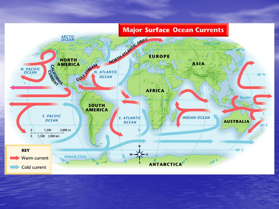
Land Breeze Land cools faster than water.
The air over the land becomes cooler than the air over the water. The warmer air rises and cooler air blows towards the water.

10
Sea Breeze vs. Land Breeze

11
Monsoons Sea and land breezes over a large region that change direction with the seasons In the summer in South and Southeast Asia, the land gradually gets warmer than the ocean. A large “sea breeze” blows steadily inland from the ocean all summer, even at night. In the winter, the land cools and becomes colder than the ocean. A “land breeze” blows steadily from the land to the ocean.

12
Global Winds Winds that blow steadily from specific directions over long distances created by convection currents in the atmosphere

13
Coriolis Effect Because Earth is rotating, global winds do not follow a straight path. As the winds move, Earth rotates from west to east underneath them, making it seem as if the winds have curved. This is called the Coriolis effect. Northern Hemisphere- winds turn toward right. Southern Hemisphere, winds curve toward left.

14
Global Wind Belts Doldrums
Regions near the equator with little or no wind. Horse Latitudes belt of calm air at about 30° north and south latitudes where the air stops moving toward the poles and sinks The Coriolis effect and other factors combine to produce a pattern of calm areas and wind belts around Earth

15
Global Wind Belts Trade Winds Prevailing Westerlies Polar Easterlies
steady easterly winds From the equator to 30° north latitude and 30° south latitude Prevailing Westerlies blow generally from the southwest between 30° and 60° north latitudes and from the northwest between 30° and 60° south latitudes. play an important part in the weather of the United States. Polar Easterlies meet the prevailing westerlies at about 60° north and 60° south latitudes, along a region called the polar front. has a major effect on weather changes in the United States.

17
Air Masses huge body of air that has similar temperature, humidity, and air pressure throughout it has the same characteristics of the surface over which it develops Classified by Humidity—Continental (dry) or Maritime (humid) Temperature—Tropical (warm, low pressure) or Polar (cold, high pressure) generally move west to east in N. America
 or Maritime (humid) Temperature—Tropical (warm, low pressure) or Polar (cold, high pressure) generally move west to east in N. America.")
18
Air Masses in N. America

19
Fronts the boundary between air masses Caused when air masses collide
Four types— warm cold stationary occluded

20
Warm Front warm air slides over departing cold air- large bands of precipitation form This is the symbol on a map for a warm front

21
Cold Fronts Cold air pushes under a warm air mass. Warm air rises quickly=narrow bands of violent storms form This is the symbol for a cold front

22
Occluded Front 2 cold air masses merge and force warm air between them to rise quickly. Strong winds and heavy precipitation will occur This is the weather map symbol for an occluded front

23
Stationary Front Warm or cold front stops moving. Light wind and precipitation may occur across the front boundary This is the weather map symbol for a stationary front

24
Currents Also Affect Weather
streams of water within the oceans that move in regular patterns Warm currents carry warm water from tropics toward the poles. Cold currents bring cold water from polar zones toward the equator. The surface of the water warms or cools the air above it. The warmed or cooled air then moves over the nearby land.

26
Weather Maps Show locations of fronts, precipitation, air masses and other data Can be used to help predict weather

27
Point out parts of weather map
Point out parts of weather map. Fronts, precipitation, low pressure areas, etc. Make predictions about weather conditions in front of or behind fronts.

Similar presentations