Download presentation
Presentation is loading. Please wait.

1
The Florida Longleaf Pine Ecosystem Geodatabase A Cooperative Project between the Florida Forest Service and Florida Natural Areas Inventory

2
LPEGDB Purpose Design and populate a spatial database to serve as central repository for information on the distribution and condition of LPEs in Florida

3
LPEGDB Need

4
3. Goals, Objectives, and Strategies Goal 1: Reliable and accurate inventories and assessments of Longleaf Pine Ecosystems (LPE) on public and private land exist in accessible databases. Objective 1.1: Develop central and accessible repositories of data on LPE collected with standardized methods to facilitate communication and coordination of efforts, to frame the scope of the issue, and to identify sites where land managers and landowners can observe restoration projects at various stages and interact with practitioners to develop realistic expectations for restoration efforts and site potential.
 on public and private land exist in accessible databases. Objective 1.1: Develop central and accessible repositories of data on LPE collected with standardized methods to facilitate communication and coordination of efforts, to frame the scope of the issue, and to identify sites where land managers and landowners can observe restoration projects at various stages and interact with practitioners to develop realistic expectations for restoration efforts and site potential..")
5
LPEGDB Objectives Accessibility to county foresters & land managers Compatibility with regional LPE mapping & other statewide natural resource databases Inform conservation, protection and management priorities for LPEs

6
LPEGDB Project Overview Mar 2012 – Dec 2013; Updates through 2015 4 Major Tasks Compile existing LPE data & identify data gaps Collect LPE field data via Rapid Assessment Integrate existing and new data into LPEGDB Summarize LPE conditions and priorities LPEGDB Existing Data Rapid Assessment LPE Distribution ConditionPriorities

7
FNAI Natural Community Mapping: 2003 – 2012 Florida Forest Service Longleaf Management Project FNAI Element Occurrence Data FNAI Other Survey Data (rare species, exotics, etc) Red-cockaded Woodpecker Data Florida Cooperative Land Cover USFS Stands LPEGDB Methods Existing Data Initial Data Sources
 Red-cockaded Woodpecker Data Florida Cooperative Land Cover USFS Stands LPEGDB Methods Existing Data Initial Data Sources")
8
Natural Community Mapping & Ecol. Assessment >60,000 ground-truth points on managed lands > 2 million acres mapped

9
Initial Data Sources Florida Cooperative Land Cover Map Compiled best available local and regional sources Aerial review of critical natural communities: scrub, sandhill, dry prairie, pine rockland, rockland hammock

10
LPEGDB Methods Existing Data Tier 1A – Longleaf Confirmed with Existing Ecological Condition Data Tier 1 – Longleaf Confirmed – High Confidence Tier 2 – Longleaf Confirmed – Moderate Confidence Tier 3 – Longleaf Likely but not Confirmed Tier 4 – Longleaf Possible but not Confirmed Confidence Tier Approx. 8 million acres included as potential LPEs

11
LPEGDB Methods Rapid Assessment 1.8 million acres deployed for Rapid Assessment Focus on presumed intact natural LPE sites

12
LPEGDB Methods Rapid Assessment Assessment design by FNAI & FFS Training by FNAI & FFS Conducted by County Foresters Rapid Field Assessment of Ecological Condition

13
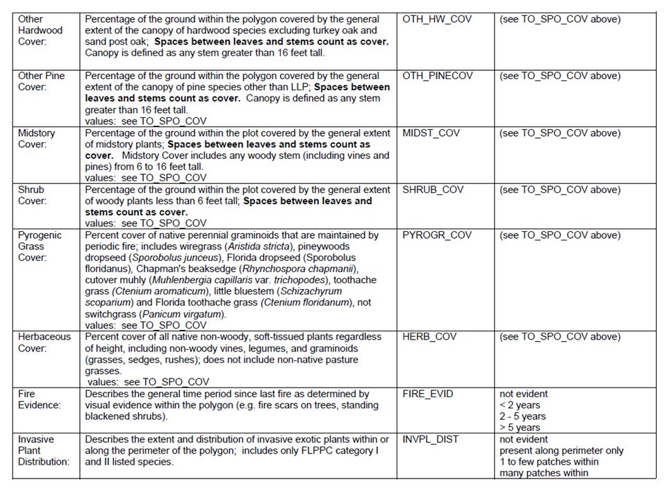
Field Attributes Longleaf Pine DominanceShrub Cover Longleaf Pine Age StructurePyrogenic Grass Cover Longleaf Pine Basal AreaHerbaceous Cover Turkey Sand Post CoverFire Evidence Other Hardwood CoverInvasive Plant Distribution Other Pine CoverCondition Rank Midstory CoverNatural Community Type Rapid Assessment Design Presence and dominance of LLP in the Canopy Dominant Codominant Occasional-rare Absent Cover of woody plants < 6 ft tall <1%26 - 35%66 - 75% 1 - 5%36 - 45%76 - 85% 6 - 15%46 - 55%86 - 95% 16 - 25%56 - 65%96 - 100%

14
Rapid Assessment Design

17
Results: Rapid Assessment Areas 79% of confirmed LPE on private lands LPE Occurrence in Rapid Assessment Areas

18
LPEGDB Methods Integration of Rapid Assessment with Existing Data LPEGDB Existing Data Rapid Assessment LPE Condition LPE Occurrence LPE Priorities

19
Methods: LPE Condition Attributes differed among sources Ecological condition crosswalk Management Levels (America’s longleaf 2010) Acres to maintain Acres to improve Acres to restore Integration of Rapid Assessment with Existing Data LPEGDB
 Acres to maintain Acres to improve Acres to restore Integration of Rapid Assessment with Existing Data LPEGDB")
20
LPE Condition to Mgmt Classes Management Class Attribute MaintainImproveRestoreSource* Longleaf Pine CanopyDominant Codominant to Occasional-Rare AbsentLMWG, FNAI Longleaf Pine Age Structure Multiple (2+) age classes One age class Absent from canopy LPC Longleaf Pine Basal Area10 - 70 70N/AFNAI Turkey Sand Post Cover<15%16 - 55%>55%FNAI Other Hardwood Cover<5%6 - 35%>35%JV, FNAI Other Pine Cover<15%16 - 45%>45%FNAI Midstory Cover<25%26 - 75%>75%LPC, LMWG Shrub Cover<30%30 - 75%>75%LPC Pyrogenic Grass Cover>20%1 - 20%<1%LPC, FNAI Herbaceous Cover>40%10 - 40%<10%LMWG Fire Evidence<5 years>5 yearsNot evidentFNAI Invasive Plant DistributionNot evident 1 to few patches or present along perimeter only Many patches within FNAI Condition RankExcellent to goodFairPoorFNAI
 age classes One age class Absent from canopy LPC Longleaf Pine Basal Area N/AFNAI Turkey Sand Post Cover<15% %>55%FNAI Other Hardwood Cover<5%6 - 35%>35%JV, FNAI Other Pine Cover<15% %>45%FNAI Midstory Cover<25% %>75%LPC, LMWG Shrub Cover<30% %>75%LPC Pyrogenic Grass Cover>20%1 - 20%<1%LPC, FNAI Herbaceous Cover>40% %<10%LMWG Fire Evidence<5 years>5 yearsNot evidentFNAI Invasive Plant DistributionNot evident 1 to few patches or present along perimeter only Many patches within FNAI Condition RankExcellent to goodFairPoorFNAI")
21
Results: LPE Condition <50% is at maintain level for many categories Maintain Improve Restore

22
Results: LPE Condition Means for establishing priorities for specific actions

23
Results: LPE Occurrence Occurrence of Longleaf Pine Ecosystems in Florida ~2.5 million acres Confirmed or Assumed LPE

24
Results: LPE Occurrence 4.8 million acres – LPE still unknown Mostly pine plantation Merits further assessment

25
v.2 Recent Updates Added condition data for many conservation lands Compare LPEGDB with other projects: FRA, CSFIAS Held Longleaf Partners Meeting for guidance on future of LPEGDB Integrate data into statewide conservation planning efforts

26
LPEGDB v.2 Summary LPEs confirmed on 2.2 million acres in Florida 76% with ecological condition data 40% on private lands An additional 300,000 acres of Longleaf natural communities identified from aerial photos

27
Next Steps Coordinate criteria and definitions for reporting longleaf acres across the partnership. Develop summaries and map products that could be easily used by individuals with limited GIS knowledge. Give priority consideration to ground cover in ecological condition assessments. Include assessment and distribution of longleaf pine planation in the database. Consider several adjustments to the rapid assessment protocol including metrics for capturing overstory composition, old-growth characteristics, and occurrence of longleaf in strata other than the canopy. Continue working with longleaf partners to enhance the compatibility of LPEGDB with regional efforts and promote similar assessments rangewide.

28
Questions

Similar presentations


 Cathy McGlynn, Coordinator, Northeast Illinois Invasive Plant Partnership.>")


