Download presentation
Presentation is loading. Please wait.

1
Utilization of Remotely Sensed Data for Targeting and Evaluating Implementation of Best Management Practices within the Wister Lake Watershed, Oklahoma Scott Stoodley, Brenda Berasi AMEC Earth and Environmental Phillip Busteed, Michael White, Daniel Storm Oklahoma State University

2
Introduction Wister Lake Watershed Located in southeast Oklahoma and Arkansas Located in southeast Oklahoma and Arkansas Eutrophic Eutrophic Listed as a Nutrient Limited Watershed (NWL) Listed as a Nutrient Limited Watershed (NWL) Listed on the State’s 303(d) list in 1998 for nutrients, siltation, suspended solids, flow alteration, taste and odor Listed on the State’s 303(d) list in 1998 for nutrients, siltation, suspended solids, flow alteration, taste and odor Oklahoma Conservation Commission (OCC) has begun using satellite imagery with water quality modelling to identify potential critical source areas of pollutants Oklahoma Conservation Commission (OCC) has begun using satellite imagery with water quality modelling to identify potential critical source areas of pollutants
 Listed as a Nutrient Limited Watershed (NWL) Listed on the State’s 303(d) list in 1998 for nutrients, siltation, suspended solids, flow alteration, taste and odor Listed on the State’s 303(d) list in 1998 for nutrients, siltation, suspended solids, flow alteration, taste and odor Oklahoma Conservation Commission (OCC) has begun using satellite imagery with water quality modelling to identify potential critical source areas of pollutants Oklahoma Conservation Commission (OCC) has begun using satellite imagery with water quality modelling to identify potential critical source areas of pollutants")
3
Objectives Utilize Landsat TM (30 meter resolution) imagery to: 1. Target Best Management Practices (BMPs) Map landcover types for use in SWAT modeling to target critical source areas of phosphorus from pasture systems Map landcover types for use in SWAT modeling to target critical source areas of phosphorus from pasture systems 2. Evaluate BMPs Evaluate the effectiveness of the OCC’s Section 319 cost share program by analyzing vegetation and pasture grazing intensity for the summer of 2000 through the summer of 2004 Evaluate the effectiveness of the OCC’s Section 319 cost share program by analyzing vegetation and pasture grazing intensity for the summer of 2000 through the summer of 2004
 Map landcover types for use in SWAT modeling to target critical source areas of phosphorus from pasture systems Map landcover types for use in SWAT modeling to target critical source areas of phosphorus from pasture systems 2. Evaluate BMPs Evaluate the effectiveness of the OCC’s Section 319 cost share program by analyzing vegetation and pasture grazing intensity for the summer of 2000 through the summer of 2004 Evaluate the effectiveness of the OCC’s Section 319 cost share program by analyzing vegetation and pasture grazing intensity for the summer of 2000 through the summer of")
4
Study Area

5
Landsat TM Imagery August/September 2004

6
Landcover Classification Categories of interest: Forest Forest Pasture, high biomass Pasture, high biomass Pasture, low biomass Pasture, low biomass Shrub / Range Shrub / Range Bare Soil Bare Soil Clear-Cut Clear-Cut Urban, high density Urban, high density Urban, low density Urban, low density Rock Outcropping Rock Outcropping Mining Mining Water Water Clouds Clouds

7
Landcover Classification Methods Unsupervised classification Unsupervised classification ISODATA clustering algorithm ISODATA clustering algorithm Iterative process Iterative process Established set of decision criteria for each landcover category Established set of decision criteria for each landcover category 3x3 Majority spatial filter used on large macro classes 3x3 Majority spatial filter used on large macro classes Change detection conducted using categorical image differencing Change detection conducted using categorical image differencing

8
Landcover Classification Methods Ground-truth data Ground-truth data Collected by OCC and Oklahoma State University (OSU) Collected by OCC and Oklahoma State University (OSU) GPS coordinates, description of landcover type, digital photos GPS coordinates, description of landcover type, digital photos 2 Data sets 2 Data sets 255 locations surveyed in July 255 locations surveyed in July and August 2005 100 locations surveyed in 100 locations surveyed in November 2005
 Collected by OCC and Oklahoma State University (OSU) GPS coordinates, description of landcover type, digital photos GPS coordinates, description of landcover type, digital photos 2 Data sets 2 Data sets 255 locations surveyed in July 255 locations surveyed in July and August locations surveyed in 100 locations surveyed in November 2005")
9
2004 Landcover Classification Water Forest High Biomass Pasture Low Biomass Pasture Shrub / Range Bare Soil Land Cover Categories Clear-cut Rock Outcropping High Density Urban Low Density Urban Mining Clouds

10
2000 Landcover Classification Water Forest High Biomass Pasture Low Biomass Pasture Shrub / Range Bare Soil Land Cover Categories Clear-cut Rock Outcropping High Density Urban Low Density Urban Mining Clouds

11
Change Detection Unchanged Water Unchanged Forest Unchanged Pasture Unchanged Shrub/Range Unchanged Bare Soil Unchanged Urban Land Cover Change from 2000 to 2004 Forest → Clear-cut Pasture → Forest Bare Soil → Forest Clouds Other

12
Riparian Buffer Zone Water Forest High Biomass Pasture Low Biomass Pasture Shrub / Range Bare Soil Clear-cut Rock Outcropping High Density Urban Low Density Urban Mining Land Cover

13
Landcover Classification

14
Accuracy Assessment 100 sites selected: 100 sites selected: Stratified random sampling design Stratified random sampling design Within ½ mile buffer of roads Within ½ mile buffer of roads Minimum of 10 sites per category Minimum of 10 sites per category

15
Ground Truth 21 July 2005 Shrub / Range 02 November 2005 Pasture Need for temporally coincident ground truth data

16
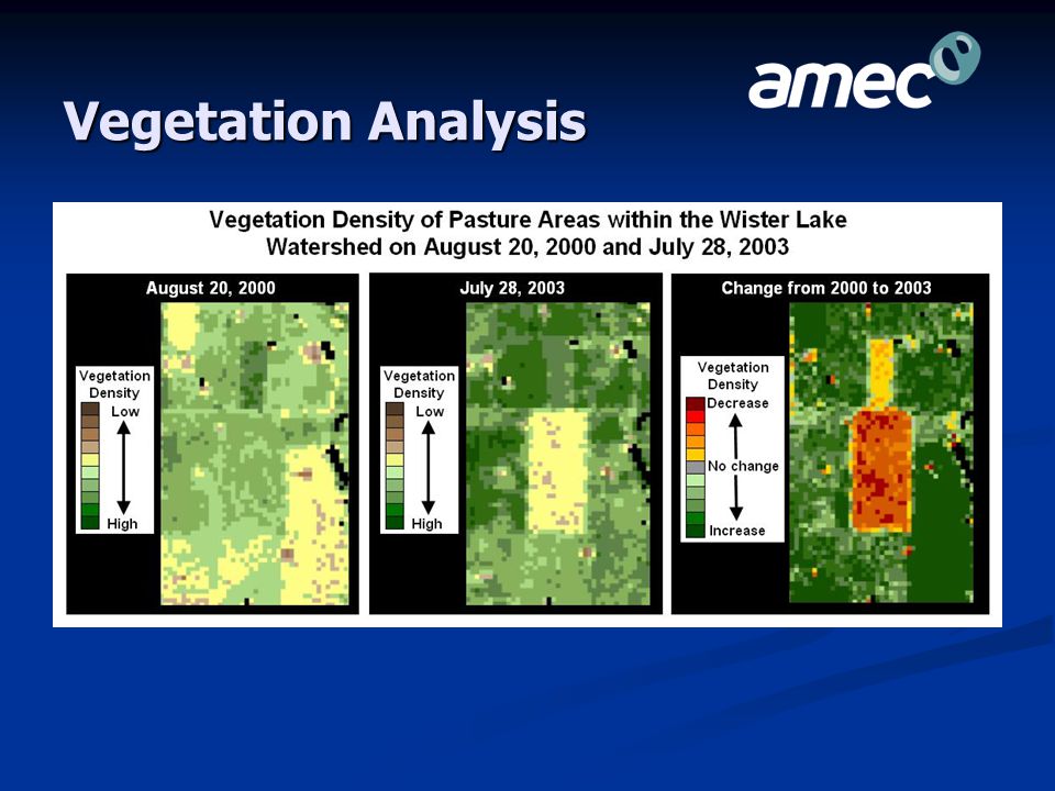
Vegetation Analysis Objective Analyze vegetation density to evaluate BMP effectiveness Analyze vegetation density to evaluate BMP effectivenessMethods Vegetation indices Vegetation indices Normalized Difference Vegetation Index Normalized Difference Vegetation Index Normalized Difference Senescent Vegetation Index Normalized Difference Senescent Vegetation Index Fractional cover of green vegetation Fractional cover of green vegetation Fractional cover of senescent vegetation Fractional cover of senescent vegetation Change detection based on percent difference from baseline Change detection based on percent difference from baseline

17
Vegetation Analysis Multi-temporal analysis 20 Aug 2000 22 Jul 2001 27 Sep 2002 28 Jul 2003 31 Aug 2004

18
Vegetation Indices Normalized difference vegetation index Normalized difference senescent vegetation index NDSVI = (SWIR-Red) (SWIR+Red) NDVI = (NIR-Red) (NIR+Red)
 (SWIR+Red) NDVI = (NIR-Red) (NIR+Red)")
19
Vegetation Indices Fractional cover of green vegetation FC gv = (NDVI-NDVI soil )/(NDVI veg -NDVI soil ) Fractional cover of senescent vegetation FC sv = (NDSVI-NDSVI soil )/(NDSVI veg -NDVSI soil ) NDVI soil and NDVI veg are the NDVI values of an area of only bare soil and an area of total vegetation, respectively, as derived from an image or measured in the field NDVI soil and NDVI veg are the NDVI values of an area of only bare soil and an area of total vegetation, respectively, as derived from an image or measured in the field
/(NDVI veg -NDVI soil ) Fractional cover of senescent vegetation FC sv = (NDSVI-NDSVI soil )/(NDSVI veg -NDVSI soil ) NDVI soil and NDVI veg are the NDVI values of an area of only bare soil and an area of total vegetation, respectively, as derived from an image or measured in the field NDVI soil and NDVI veg are the NDVI values of an area of only bare soil and an area of total vegetation, respectively, as derived from an image or measured in the field")
20
All four indices computed for the pasture areas of the Oklahoma portion of the watershed All four indices computed for the pasture areas of the Oklahoma portion of the watershed Change depicted as percent departure from 2000 Change depicted as percent departure from 2000 Vegetation Analysis

23
Evaluation of BMP effectiveness: Mean FC gc and FC sv computed for 255 individual cost share fields Mean FC gc and FC sv computed for 255 individual cost share fields Computed ratio of the mean FC for each cost-share field to that of all other pastures within a given year Computed ratio of the mean FC for each cost-share field to that of all other pastures within a given year Ratio 2000 – Ratio 2004 computed for each field Ratio 2000 – Ratio 2004 computed for each field ∑ Ratio 2000 – Ratio 2004 for all fields that had implemented the same combination of BMPs ∑ Ratio 2000 – Ratio 2004 for all fields that had implemented the same combination of BMPs Area weighted average was also computed for the sum of the differences Area weighted average was also computed for the sum of the differences

24
Evaluation of BMPs Some BMPs, such as a fence only, resulted in an overall increase in FC gv and FC sv of the cost share fields relative to all of the non-cost share fields for 2004 compared to 2000. Some BMPs, such as a fence only, resulted in an overall increase in FC gv and FC sv of the cost share fields relative to all of the non-cost share fields for 2004 compared to 2000. Others, such as the combination of lime and fertilizer, resulted in an overall increase in FC gv and an overall decrease in FC sv relative to all of the non- cost share fields for 2004 compared to 2000. Others, such as the combination of lime and fertilizer, resulted in an overall increase in FC gv and an overall decrease in FC sv relative to all of the non- cost share fields for 2004 compared to 2000.

25
Conclusions: Land cover classification The land cover classification indicates a watershed dominated by forest, followed by pasture. The land cover classification indicates a watershed dominated by forest, followed by pasture. The change detection reveals a dynamic environment in which nearly 19% of the Oklahoma portion of the watershed underwent a change in land cover from 2000 to 2004. The change detection reveals a dynamic environment in which nearly 19% of the Oklahoma portion of the watershed underwent a change in land cover from 2000 to 2004. Overall accuracy of 2004 land cover classification was 93.0% Overall accuracy of 2004 land cover classification was 93.0%

26
Conclusions: Landcover Classification Classification within the riparian zone offers a qualitative targeting method to spatially locate high risk landcover types. Classification within the riparian zone offers a qualitative targeting method to spatially locate high risk landcover types. When combined with estimates of nonpoint source loadings through SWAT modeling, the landcover classification provides a mechanism by which to proactively identify and target areas that are likely contributing to water quality degradation. When combined with estimates of nonpoint source loadings through SWAT modeling, the landcover classification provides a mechanism by which to proactively identify and target areas that are likely contributing to water quality degradation.

27
Conclusions: Vegetation Analysis No clear trend was found in overall FC for the cost share fields relative to the non-cost share fields in 2004 compared to 2000. No clear trend was found in overall FC for the cost share fields relative to the non-cost share fields in 2004 compared to 2000. Some BMPs resulted in increased FC, whereas others resulted in decreased FC. Some BMPs resulted in increased FC, whereas others resulted in decreased FC. The overall effect of BMP implementation on vegetation density may be obscured by changes in land-use management decisions. The overall effect of BMP implementation on vegetation density may be obscured by changes in land-use management decisions.

28
Conclusions: Vegetation Analysis By gathering data on the land management practices that had been implemented between 2000 and 2004, a better understanding of the effectiveness of the BMPs may be attained. By gathering data on the land management practices that had been implemented between 2000 and 2004, a better understanding of the effectiveness of the BMPs may be attained. The OCC should consider the possibility of placing management restrictions in conjunction with Section 319 funding for BMP implementation. The OCC should consider the possibility of placing management restrictions in conjunction with Section 319 funding for BMP implementation.

29
For More Information: Brenda Berasi AMEC Earth & Environmental brenda.berasi@amec.com (978) 692-9090
")
Similar presentations