Download presentation
Presentation is loading. Please wait.

4
Maritime zones

7
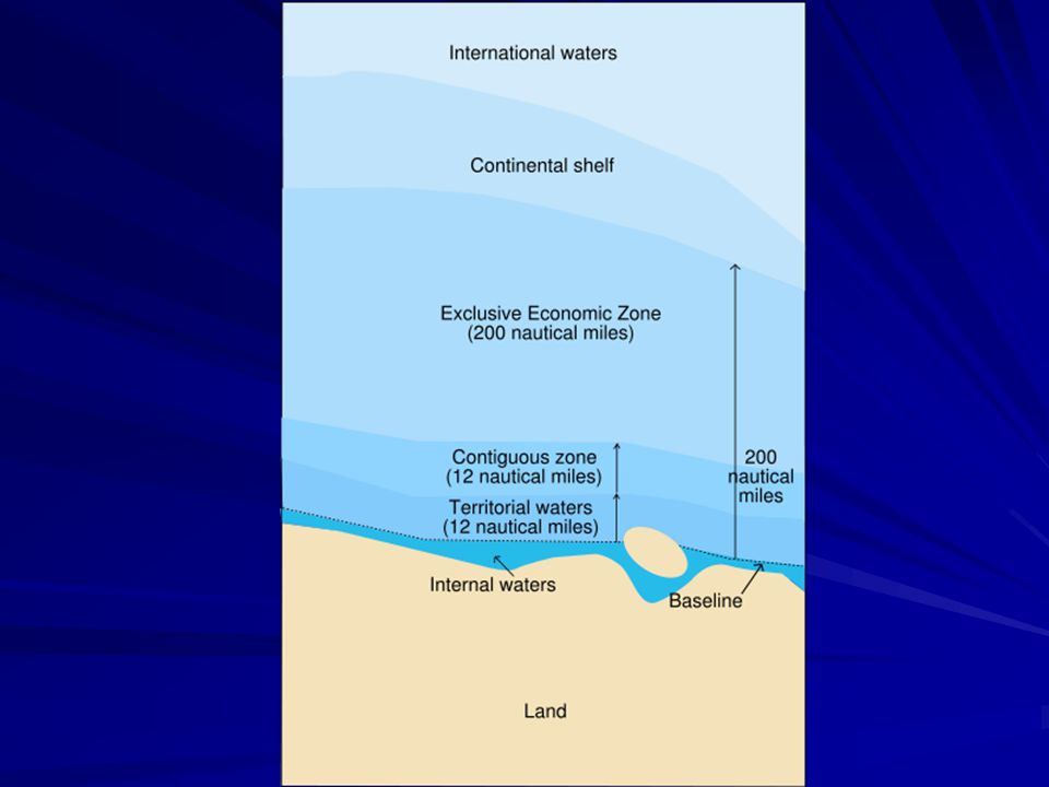
Maritime Zones Internal waters. Waters on the landward side of the baseline. The coastal state exercises full sovereignty, and these waters form an integral part of the state’s territory. Includes rivers, lakes and bays. Territorial Sea. The belt of water 12 nautical miles from from the baseline. The sovereignty of the coastal state extends to the territorial sea, its seabed and subsoil, and to the air space above it. That sovereignty is subject solely to the right of innocent passage for foreign ships. Contiguous Zone. The belt of water contiguous to the territorial sea, the outer limit of which does not exceed 24 nautical miles from the baseline. The coastal state exercises control necessary its customs, fiscal, immigration or sanitary laws.

8
UNCLOS. Legal status of the territorial sea, of the air space over the territorial sea and of its bed and subsoil 1. The sovereignty of a coastal State extends beyond its land territory and internal waters and, in the case of an archipelagic State, its archipelagic waters, to an adjacent belt of sea, described as the territorial sea. 2. This sovereignty extends to the air space over the territorial sea as well as to its bed and subsoil.

9
Innocent Passage Passage not prejudicial to the peace, good order or security of the coastal State Not innocent: (a) any threat or use of force against the sovereignty, territorial integrity or political independence of the coastal State, …. (b) any exercise or practice with weapons of any kind;… (g) the loading or unloading of any commodity, currency or person contrary to the customs, fiscal, immigration or sanitary laws and regulations of the coastal State; (h) any act of wilful and serious pollution contrary to this Convention; (i) any fishing activities; (j) the carrying out of research or survey activities;
 any threat or use of force against the sovereignty, territorial integrity or political independence of the coastal State, …. (b) any exercise or practice with weapons of any kind;… (g) the loading or unloading of any commodity, currency or person contrary to the customs, fiscal, immigration or sanitary laws and regulations of the coastal State; (h) any act of wilful and serious pollution contrary to this Convention; (i) any fishing activities; (j) the carrying out of research or survey activities;")
10
Territorial Baselines
The line from which the maritime zones are measured. Drawn at the low water line along the coast, including the coasts of islands. Straight baselines are a system of straight lines joining specified or discrete points on the low-water line. “Must not depart to any appreciable extent from the general direction of the coast, and the sea areas lying within the lines must be sufficiently closely linked to the land domain to be subject to the regime of internal waters.” Bay- or river-closing lines are straight lines drawn between the respective low-water lines of the natural entrance points of bays or rivers

11
Bays “A well-marked indentation whose penetration is in such proportion to the width of its mouth as to contain land-locked waters and constitute more than a mere curvature of the coast. [I]ts area [must be at least] as large as [a] semi-circle whose diameter is a line drawn across the mouth of that indentation.”

12
High Seas Not subject to the sovereignty or jurisdiction of any state
Subject to the freedom of the high seas, namely: a) freedom of navigation; (b) freedom of overflight; (c) freedom to lay submarine cables and pipelines (d) freedom to construct artificial islands and other installations (e) freedom of fishing (f) freedom of scientific research
 freedom of navigation; (b) freedom of overflight; (c) freedom to lay submarine cables and pipelines. (d) freedom to construct artificial islands and other installations. (e) freedom of fishing. (f) freedom of scientific research.")
13
Continental Shelf “The natural prolongation of its land territory to the outer edge of the continental margin” Consists of the seabed and subsoil of the shelf, the slope and the rise Extends to at most 200 nautical miles from the baselines Largely coextensive with the Exclusive Economic Zone likewise covering 200 nautical miles from the baselines Can be extended to the outer edge of the continental margin

14
Continental Shelf

15
Continental Shelf

17
Exclusive Economic Zone
The area beyond the territorial sea, not exceeding 200 nautical miles from the baseline. The coastal state has sovereign rights for the purpose of exploring and exploiting, conserving and managing all natural resources of the waters superjacent to the seabed and of the seabed and its subsoil together with other activities such as the production of energy from water, currents and wind the establishment and use of artificial islands, installations and structures, marine scientific research, the protection and preservation of the marine environment

19
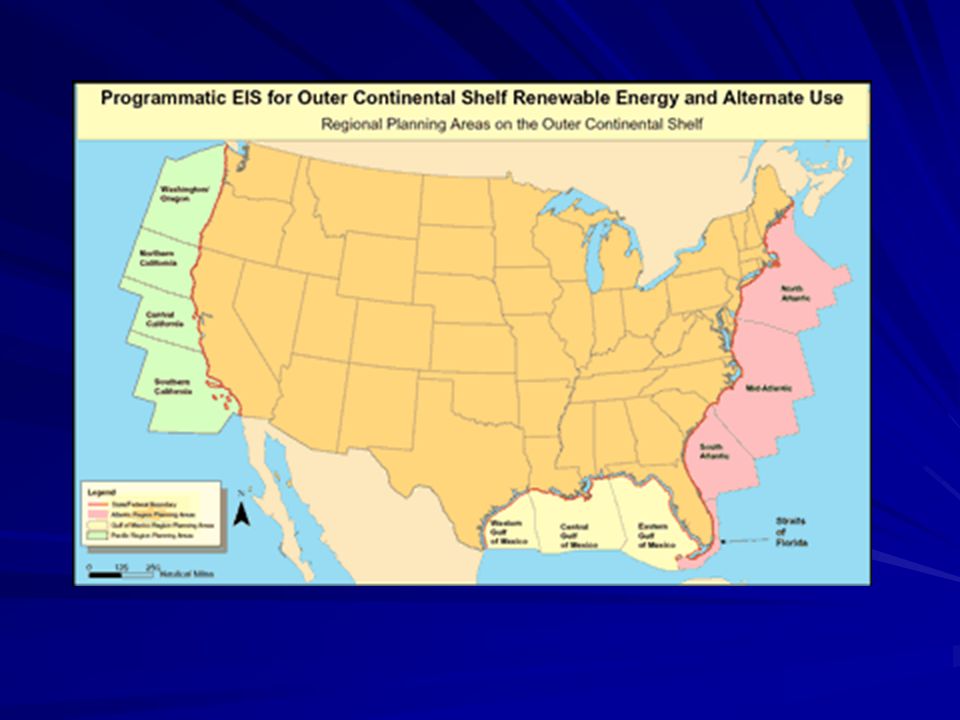
US Exclusive Economic Zone

25
International Sea-Lanes

26
1898 Treaty of Paris Treaty of Peace Between the United States and Spain (10 December 1898)
Article 3. Spain cedes to the United States the archipelago known as the Philippine Islands, and comprehending the islands lying within the following line: ….

28
Felipe Agoncillo's Protest to the US Senate during the debates on the Treaty of Paris
“If the Spaniards have not been able to transfer to the Americans the rights which they did not possess; if the [Americans] have not militarily conquered positions in the Philippines; if the occupation of Manila was a resultant fact, prepared by the Filipinos; if the … representatives of the Republic of the USA offered to recognize the independence and sovereignty of the Philippines, solicited and accepted their alliance how can they now constitute themselves as arbiters of the control, administration and future government of the Philippine Islands?”

30
Maritime Zones under the UNCLOS
Internal Waters Subject to sovereignty Baselines Normal. Low-water line along the coast. Straight. If coast is deeply indented. Archipelagic. Outermost points of outermost islands and reefs Landward waters are considered internal waters. Subject to sovereignty Territorial Sea Contiguous Zone Subject to jurisdiction for customs, fiscal, immigration or sanitary controls Exclusive Economic Zone Sovereign rights to explore and exploit natural resources Continental Shelf (submerged prolongation of landmass)
")
31
Constitutional Framework of Philippine Treaty Obligations under the UNCLOS
No treaty or international agreement shall be valid and effective unless concurred in by at least two-thirds of all the Members of the Senate. (Const. art. VII sec. 21) The Philippines adopts the generally accepted principles of international law as part of the law of the land. (Const. art. II sec. 2)
 The Philippines adopts the generally accepted principles of international law as part of the law of the land. (Const. art. II sec. 2)")
32
Philippine Constitution The National Territory (Article 1)
The national territory comprises the Philippine archipelago, with all the islands and waters embraced therein, and all other territories over which the Philippines has sovereignty or jurisdiction, consisting of its terrestrial, fluvial and aerial domains, including its territorial sea, the seabed, the subsoil, the insular shelves, and other submarine areas. The waters around, between, and connecting the islands of the archipelago, regardless of their breadth and dimensions, form part of the internal waters of the Philippines.

33
Itemization of National Territory
Comprises the Philippine archipelago, with all the islands and waters embraced therein The waters around, between, and connecting the islands of the archipelago, regardless of their breadth and dimensions, form part of the internal waters of the Philippines Comprises sovereignty or jurisdiction, consisting of its terrestrial, fluvial and aerial domains,including its territorial sea, the seabed, the subsoil, the insular shelves, and other submarine areas.

34
Constitutional Implications
The State shall pursue an independent foreign policy. In its relations with other states, the paramount consideration shall be national sovereignty, territorial integrity, national interest, and the right to self-determination. (Const. art. II sec. 7) The State shall protect the nation's marine wealth in its archipelagic waters, territorial sea, and exclusive economic zone. (Const. XII sec. 2) All lands of the public domain, waters, minerals, coal, petroleum, and other mineral oils, all forces of potential energy, fisheries, forests or timber, wildlife, flora and fauna, and other natural resources are owned by the State. …. (Const. XII sec. 2) The Armed Forces of the Philippines is the protector of the people and the State. Its goal is to secure the sovereignty of the State and the integrity of the national territory. (Const. II sec. 3)
 The State shall protect the nation s marine wealth in its archipelagic waters, territorial sea, and exclusive economic zone. (Const. XII sec. 2) All lands of the public domain, waters, minerals, coal, petroleum, and other mineral oils, all forces of potential energy, fisheries, forests or timber, wildlife, flora and fauna, and other natural resources are owned by the State. …. (Const. XII sec. 2) The Armed Forces of the Philippines is the protector of the people and the State. Its goal is to secure the sovereignty of the State and the integrity of the national territory. (Const. II sec. 3)")
35
Mischief Reef

36
An island??? Mischief Reef

37
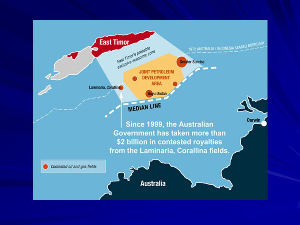
Islands Island (Article 123.1) A naturally formed area of land
Surrounded by water Above water at high tide Generates its own territorial sea, contiguous zone, EEZ and continental shelf Rocks (Article 123.3) Cannot sustain human habitation No economic life of its own Generate own territorial sea and contiguous zone But no EEZ or continental shelf Artificial islands (Article 60.8) Not islands. No territorial sea, EEZ, continental shelf. Do not affect delimitation. Low-tide elevations (Article 13). Naturally formed Above water at low tide, submerged at high tide. May be used to draw baseline. If beyond territorial sea, does not have territorial sea of its own.
 Cannot sustain human habitation. No economic life of its own. Generate own territorial sea and contiguous zone. But no EEZ or continental shelf. Artificial islands (Article 60.8) Not islands. No territorial sea, EEZ, continental shelf. Do not affect delimitation. Low-tide elevations (Article 13). Naturally formed. Above water at low tide, submerged at high tide. May be used to draw baseline. If beyond territorial sea, does not have territorial sea of its own.")
38
Mischief Reef

41
Pulau Sipadan/Ligitan

42
Pulau Sipadan

43
Aerial Photo of Pulau Sipadan

44
Baselines Normal baseline. Except where otherwise provided in this Convention, the normal baseline for measuring the breadth of the territorial sea is the low-water line along the coast as marked on large-scale charts officially recognized by the coastal State. (UNCLOS art. 5) Archipelagic baselines. An archipelagic State may draw straight archipelagic baselines joining the outermost points of the outermost islands and drying reefs of the archipelago . (UNCLOS art. 47 sec. 1) The drawing of such baselines shall not depart to any appreciable extent from the general configuration of the archipelago. (UNCLOS art. 47sec. 3).
 Archipelagic baselines. An archipelagic State may draw straight archipelagic baselines joining the outermost points of the outermost islands and drying reefs of the archipelago . (UNCLOS art. 47 sec. 1) The drawing of such baselines shall not depart to any appreciable extent from the general configuration of the archipelago. (UNCLOS art. 47sec. 3).")
45
Archipelago Archipelagic State: a State constituted wholly by one or more archipelagos and may include other islands Archipelago: a group of islands, including parts of islands, interconnecting waters and other natural features which are so closely interrelated that such islands, waters and other natural features form an intrinsic geographical, economic and political entity, or which historically have been regarded as such. (UNCLOS art. 46)
")
46
Old Philippine Baselines Law
An Act to Define the Baselines of the Territorial Sea of the Philippines (17 June 1961), as amended by Republic Act No. 5446, An Act to Amend Section One of the RA 3046, Entitled "An Act to Define the Baselines of the Territorial Sea of the Philippines"(18 September 1968). “All the waters around, between and connecting the various islands of the Philippine archipelago, irrespective of their width or dimension [are] necessary appurtenances of the land territory, forming part of the inland or internal waters of the Philippines. In addition, “all the waters beyond the outermost islands of the archipelago but within the limits of the [Treaty of Paris] comprise the territorial sea of the Philippines. Finally, this statute indicates that the baselines will consist of straight lines joining appropriate points of the outermost islands of the archipelago.
, as amended by Republic Act No. 5446, An Act to Amend Section One of the RA 3046, Entitled An Act to Define the Baselines of the Territorial Sea of the Philippines (18 September 1968). All the waters around, between and connecting the various islands of the Philippine archipelago, irrespective of their width or dimension [are] necessary appurtenances of the land territory, forming part of the inland or internal waters of the Philippines. In addition, all the waters beyond the outermost islands of the archipelago but within the limits of the [Treaty of Paris] comprise the territorial sea of the Philippines. Finally, this statute indicates that the baselines will consist of straight lines joining appropriate points of the outermost islands of the archipelago.")
47
UNCLOS again INTERNAL WATERS
[W]aters on the landward side of the baseline of the territorial sea form part of the internal waters of the State. (UNCLOS art. 12 sec. 1) Within its archipelagic waters, the archipelagic State may draw closing lines for the delimitation of internal waters. (UNCLOS art. 50) TERRITORIAL SEA The sovereignty of a coastal State extends, beyond its land territory and internal waters and, in the case of an archipelagic State, its archipelagic waters, to an adjacent belt of sea, described as the territorial sea. 2. This sovereignty extends to the air space over the territorial sea as well as to its bed and subsoil. (UNCLOS art. 2)
 Within its archipelagic waters, the archipelagic State may draw closing lines for the delimitation of internal waters. (UNCLOS art. 50) TERRITORIAL SEA. The sovereignty of a coastal State extends, beyond its land territory and internal waters and, in the case of an archipelagic State, its archipelagic waters, to an adjacent belt of sea, described as the territorial sea. 2. This sovereignty extends to the air space over the territorial sea as well as to its bed and subsoil. (UNCLOS art. 2)")
48
ICJ Statute The states parties to the present Statute may at any time declare that they recognize as compulsory ipso facto and without special agreement, in relation to any other state accepting the same obligation, the jurisdiction of the Court in all legal disputes. (art. 38) PHILIPPINE RESERVATIONS: (i) in respect of the natural resources of the sea-bed and subsoil of the continental shelf of the Philippines, or its analogue in an archipelago; or (ii) in respect of the territory of the Republic of the Philippines, including its territorial seas and inland waters
 PHILIPPINE RESERVATIONS: (i) in respect of the natural resources of the sea-bed and subsoil of the continental shelf of the Philippines, or its analogue in an archipelago; or (ii) in respect of the territory of the Republic of the Philippines, including its territorial seas and inland waters.")
49
Other Relevant Marcos Issuances
Presidential Proclamation No. 370, Declaring as Subject to the Jurisdiction and Control of the Republic of the Philippines all Mineral and other Natural Resources in the Continental Shelf (20 March 1968). Presidential Decree No. 1599, Establishing an Exclusive Economic Zone and for other purposes (11 June 1978).
. Presidential Decree No. 1599, Establishing an Exclusive Economic Zone and for other purposes (11 June 1978).")
50
Kalayaan Islands Group
Presidential Decree No. 1596, Declaring Certain Area Part Of The Philippine Territory And Providing For Their Government And Administration (11 June 1978). WHEREAS, by reason of their proximity the cluster of islands and islets in the South China Sea situated within the following: Kalayaan Islands Group are vital to the security and economic survival of the Philippines; WHEREAS, much of the above area is part of the continental margin of the Philippine archipelago; WHEREAS, these areas do not legally belong to any state or nation but, by reason of history, indispensable need, and effective occupation and control established in accordance with the international law, such areas must now deemed to belong and subject to the sovereignty of the Philippines; WHEREAS, while other states have laid claims to some of these areas, their claims have lapsed by abandonment and can not prevail over that of the Philippines on legal, historical, and equitable grounds
. WHEREAS, by reason of their proximity the cluster of islands and islets in the South China Sea situated within the following: Kalayaan Islands Group are vital to the security and economic survival of the Philippines; WHEREAS, much of the above area is part of the continental margin of the Philippine archipelago; WHEREAS, these areas do not legally belong to any state or nation but, by reason of history, indispensable need, and effective occupation and control established in accordance with the international law, such areas must now deemed to belong and subject to the sovereignty of the Philippines; WHEREAS, while other states have laid claims to some of these areas, their claims have lapsed by abandonment and can not prevail over that of the Philippines on legal, historical, and equitable grounds.")
51
2 Modes for Fixing the Baselines
OPTION 1: Full archipelagic treatment (UNCLOS art. 47) (embodied in the bill approved by the House of Representatives), which will encompass the entire Philippine territory – including the disputed islands – within archipelagic baselines OPTION 2: Mixed archipelagic plus a regime of islands (embodied in the bill approved by the Philippine Senate and adopted by the Bicameral Conference Committee) (a) For the uncontested islands (presumably covering all the islands within the treaty lines under the 1898 Treaty of Paris), use archipelagic baselines (b) For the contested islands, use normal baselines around each island (regime of islands).
 (embodied in the bill approved by the House of Representatives), which will encompass the entire Philippine territory – including the disputed islands – within archipelagic baselines. OPTION 2: Mixed archipelagic plus a regime of islands (embodied in the bill approved by the Philippine Senate and adopted by the Bicameral Conference Committee) (a) For the uncontested islands (presumably covering all the islands within the treaty lines under the 1898 Treaty of Paris), use archipelagic baselines. (b) For the contested islands, use normal baselines around each island (regime of islands).")
52
Sub-Options under Mixed Archipelago/Islands Regime
Main archipelago only under archipelagic lines; Scarborough and KIG as regime of islands Main Archipelago plus Scarborough under archipelagic lines; KIG as regime of islands Main archipelago plus KIG under archipelagic lines; Scarborough as regime of islands Everything within archipelagic baselines

53
RA 9522 (10 March 2009) Identical Baselines with 1961 Baselines Law
Maintains archipelagic baselines for main archipelago Adopts regime of islands for KIG and Scarborough Shoal

54
Codes of Conduct 1992 Asean Declaration on the Conduct of Parties in the South China Sea 2002 China-Asean Declaration on the Conduct of Parties in the South China Sea

55
1992 Asean Declaration involves sensitive questions of sovereignty and jurisdiction necessity to resolve [issues] by peaceful means, without resort to force urges all parties concerned to exercise restraint RESOLVE, without prejudicing the sovereignty and jurisdiction of countries having direct interests in the area, to explore the possibility of cooperation in the South China Sea

56
Joint Development Agreements
China-Phil-Vietnam Joint Marine Seismic Agreement Malaysia-Thailand Joint Development Area Malaysia-Vietnam “Joint Defined” Area 1989 and 2006 Timor Gap Agreements 2006 Vietnam-Cambodia Joint Historic Waters

57
China-Philippine Joint Exploration

58
2005 Version

59
China-Philippines-Vietnam Joint Marine Scientific Research
Affirm commitment to UNCLOS and China-Asean Code of Conduct Recognize authorization by respective states “Signing of this agreement shall not undermine the basic position held by [each Government] on the South China Sea issue”

60
all expenses incurred and benefits shall be equitably shared
Thailand and Malaysia on Delimitation of Continental Shelf Boundary MoU (2002) If any single geological petroleum or natural gas structure or field, or any mineral deposit of whatever character, extends across the boundary lines the two Governments shall communicate to each other all information in this regard shall seek to reach agreement as to the manner in which the structure, field or deposit will be most effectively exploited all expenses incurred and benefits shall be equitably shared
 If any single geological petroleum or natural gas structure or field, or any mineral deposit of whatever character, extends across the boundary lines. the two Governments shall communicate to each other all information in this regard. shall seek to reach agreement as to the manner in which the structure, field or deposit will be most effectively exploited. all expenses incurred and benefits shall be equitably shared.")
61
Common Petroleum Deposits
If any single geological petroleum or natural gas structure extends across the [fixed boundary] line And the part which is situated on one side of the said line is exploitable, wholly or in part, from the other side of the said line The two Governments shall seek to reach agreement as to the manner in which the structure shall be most effectively exploited.

62
East Timor

63
Timor Gap

64
Timor Gap

65
Timor Gap

67
Self-determination (Common Article 1, HR Covenants)
1. All peoples have the right of self-determination. By virtue of that right they freely determine their political status and freely pursue their economic, social and cultural development. 2. All peoples may, for their own ends, freely dispose of their natural wealth and resources without prejudice to any obligations arising out of international economic co-operation, based upon the principle of mutual benefit, and international law. In no case may a people be deprived of its own means of subsistence.

68
Permanent Sovereignty over Natural Resources (G.A. res. 1803 (XVII))
1. The right of peoples and nations to permanent sovereignty over their natural wealth and resources must be exercised in the interest of their national development and of the well-being of the people of the State concerned. … 3. … The profits derived must be shared in the proportions freely agreed upon, in each case, between the investors and the recipient State, due care being taken to ensure that there is no impairment, for any reason, of that State's sovereignty over its natural wealth and resources.

Similar presentations


 National University of Singapore UNCLOS Legal Regimes and Green Cable Systems JTF Workshop.>")


 (entered into force 1994). Note: The Deep Sea.>")


