Download presentation
Presentation is loading. Please wait.

1
Mountain Weather and Climate ATM 619: Atmospheric Science Seminar Series Department of Earth and Atmospheric Sciences University at Albany W. James Steenburgh Department of Meteorology and NOAA Cooperative Institute for Regional Prediction University of Utah jimsteen@met.utah.edu Rocky Mountain Cyclone Evolution

2
Western North America geography University of Texas/U.S. CIA

3
Topography of western United States Colorado Rockies 4250+ m peaks Cheyenne Gap <2250 m Teton, Wind River, and Big Horn Ranges 3500+ m peaks Snake River Plain 850-2000 m Sierra Nevada 3500-4500 m Basin and Range Topography Central Idaho/SW Montana Ranges 3000-4000 m Cascades 1250-2500 m Northern Montana/Idaho 2500-3000 m Wasatch & Uinta Mts 3000-3500 m

4
Topography of western Canada Northern BC Range 2500-3000 m MacKenzie Range 2000-3000 m Coast Range 2000-3000 m Natural Resources Canada SW Alberta, SE BC Ranges 3000-3500+ m Mt. Logan 5959 m Weakness <2000m Weakness <1500m

5
Climatology of the Rocky Mountain region Canadian Coast and Rocky Mtn ranges lie downstream of Pacific storm track Cyclolysis common on windward side Cyclogenesis common to lee Lee cyclones can usually be traced to a Pacific trough or cyclone Cyclogenesis maxima also found to lee of Sierra Nevada and Colorado Rockies Zishka and Smith (1980)
")
6
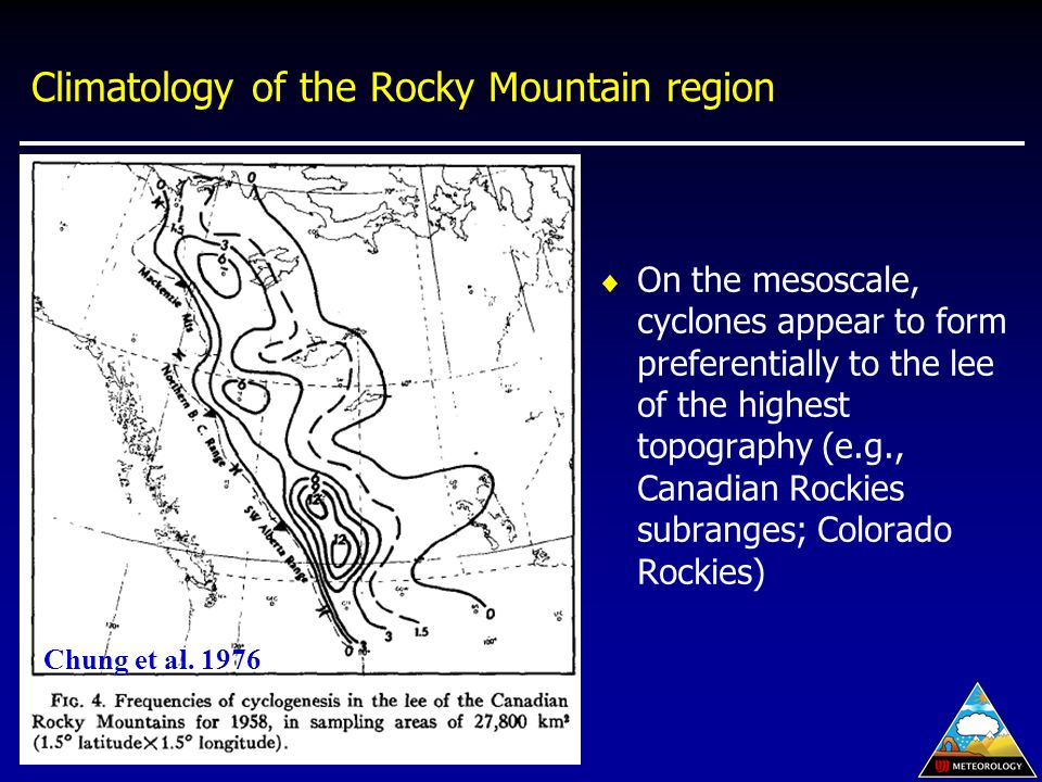
Climatology of the Rocky Mountain region On the mesoscale, cyclones appear to form preferentially to the lee of the highest topography (e.g., Canadian Rockies subranges; Colorado Rockies) Chung et al. 1976
7
Orographically modified cyclone evolution over the Rocky Mountains Most lee cyclones can be traced to an upstream precursor over the Pacific Ocean Cyclone development or evolution is “masked” by the topography “Lee cyclogenesis” might be better viewed as a case of orographically modified cyclone evolution Can break Rocky Mountain cyclone evolution into three major categories Alberta cyclones Colorado cyclones Great Basin cyclones

8
Composite evolution of Alberta Cyclones (t=-36 h) Alberta cyclogenesis is preceded by the landfall of a Pacific Cyclone and associated upper-level trough L Steenburgh (1995): Composite 36-h prior to Alberta Cyclogenesis 500 mb SLP H H
 Alberta cyclogenesis is preceded by the landfall of a Pacific Cyclone and associated upper-level trough L Steenburgh (1995): Composite 36-h prior to Alberta Cyclogenesis 500 mb SLP H H")
9
Composite evolution of Alberta cyclones (t=-12h) Mesoscale lee trough forms to lee of Rockies in response to increased cross-barrier flow Upper-level trough begins to move over Rockies L Steenburgh (1995): Composite 12-h prior to Alberta Cyclogenesis 500 mb SLP H H
 Mesoscale lee trough forms to lee of Rockies in response to increased cross-barrier flow Upper-level trough begins to move over Rockies L Steenburgh (1995): Composite 12-h prior to Alberta Cyclogenesis 500 mb SLP H H")
10
Composite evolution of Alberta cyclones (t=0h) Upper-level trough moves over Rockies CVA and downslope contribute to low level cyclonic vorticity production Cyclogenesis occurs east of the Rockies within lee trough The lee trough develops southward and broadens in scale Major low center remains over Gulf of Alaska L Steenburgh (1995): Composite 0-h prior to Alberta Cyclogenesis 500 mb SLP L H H
 Upper-level trough moves over Rockies CVA and downslope contribute to low level cyclonic vorticity production Cyclogenesis occurs east of the Rockies within lee trough The lee trough develops southward and broadens in scale Major low center remains over Gulf of Alaska L Steenburgh (1995): Composite 0-h prior to Alberta Cyclogenesis 500 mb SLP L H H")
11
Composite evolution of Alberta cyclones (t=12h) Upper-level trough and downstream CVA move east of Rockies Cross-barrier flow weakens as crest-level winds veer to NW Orography plays a less prominent role in cyclone development Cyclone moves SE away from mountains (and may fill in some cases) Northern portion of lee trough moves away from mountains while southern portion remains fixed to topography L Steenburgh (1995): Composite 12-h after Alberta Cyclogenesis 500 mb SLP L H
 Upper-level trough and downstream CVA move east of Rockies Cross-barrier flow weakens as crest-level winds veer to NW Orography plays a less prominent role in cyclone development Cyclone moves SE away from mountains (and may fill in some cases) Northern portion of lee trough moves away from mountains while southern portion remains fixed to topography L Steenburgh (1995): Composite 12-h after Alberta Cyclogenesis 500 mb SLP L H")
12
Case study of Alberta cyclone evolution Mesoscale lee trough and incipient low form east of Alberta Rockies in response to cross-barrier flow Cold air located east of Rockies due to prior surge of high pressure Cyclogenesis commences within lee trough as CVA associated with a 500-mb short-wave trough begins to move over lee of Rockies 500 mb SLP Steenburgh and Mass (1994): 1800 UTC 4 March 1986
: 1800 UTC 4 March 1986")
13
Case study of Alberta cyclone evolution Cyclone deepens and moves southeastward as the 500-mb short-wave trough moves over Rockies Lee trough extends further equatorward along lee slopes of Rockies, intensifies, and broadens in scale Confluent frontogenesis intensifies the pre-existing leeside baroclinic zone ahead of the lee trough Steenburgh and Mass (1994): 1800 UTC 4 March 1986 500 mb SLP L
: 1800 UTC 4 March mb SLP L")
14
Case study of Alberta cyclone evolution Cross sections illustrating intensification of lee-side baroclinic zone and secondary circulation Steenburgh and Mass (1994) 0600 UTC 4 March 1200 UTC 4 March 1800 UTC 4 March 0000 UTC 5 March
 0600 UTC 4 March 1200 UTC 4 March 1800 UTC 4 March 0000 UTC 5 March")
15
Case study of Alberta cyclone evolution Low center and northern portion of lee trough move eastward To south, lee trough remains fixed to topography Cold advection beneath upper-level trough destabilizes boundary layer behind lee trough – low-level cold advection develops Arctic front, which was dammed against Rockies, rotates around low Steenburgh and Mass (1994): 0000 UTC and 0600 UTC 5 March 1986 L L
: 0000 UTC and 0600 UTC 5 March 1986 L L")
16
Case study of Alberta cyclone evolution Post-lee-trough baroclinic zone overtakes lee trough Cold-advection and 500-mb CVA overrun lee trough Result: Structure resembling warm occlusion QG vertical motion, cloud, and precipitation formation can occur downstream of surface trough position Steenburgh and Mass (1994): 1200 UTC 5 March 1986 L
: 1200 UTC 5 March 1986 L")
17
Case study of Alberta cyclone evolution Cross sections depicting formation of of warm occluded-like structure (Steenburgh and Mass 1994) 1800 UTC 4 March 0000 UTC 5 March 0600 UTC 5 March 1200 UTC 5 March
 1800 UTC 4 March 0000 UTC 5 March 0600 UTC 5 March 1200 UTC 5 March")
18
Palmén and Newton (1969) conceptual model Stage A –Frontal cyclone approaches coast –Anticyclone over western U.S. Stage B –Lee trough and low-level warm anomaly amplify east of Rockies –Vorticity is generated in the lee trough by orographic processes –Still have upper-level AVA –Lee trough/cyclonic vorticity is held fixed to eastern slope

19
Palmén and Newton (1969) conceptual model Stage C –CVA moves over lee trough, further enhancing cyclonic development –Lee trough broadens as air warmed by descent spreads eastward –Rapid development continues until the cold front moves into the lee trough, winds shift to NW, and downslope flow ceases
 conceptual model Stage C –CVA moves over lee trough, further enhancing cyclonic development –Lee trough broadens as air warmed by descent spreads eastward –Rapid development continues until the cold front moves into the lee trough, winds shift to NW, and downslope flow ceases")
20
Palmén and Newton (1969) conceptual model Stage D –Direct orographic contribution to development ceases –Orographic generation of vorticity continues to the south –Cyclone drifts equatorward relative to steering layer flow –Downstream development continues by “normal” processes
 conceptual model Stage D –Direct orographic contribution to development ceases –Orographic generation of vorticity continues to the south –Cyclone drifts equatorward relative to steering layer flow –Downstream development continues by normal processes")
21
Palmén and Newton (1969) conceptual model “The overall process is one in which vorticity is generated in the low-level lee trough, which is held fixed to the eastern slope, and is finally overtaken by the divergence region aloft as the upper-level trough approaches” –Palmén and Newton (1969)
 conceptual model The overall process is one in which vorticity is generated in the low-level lee trough, which is held fixed to the eastern slope, and is finally overtaken by the divergence region aloft as the upper-level trough approaches –Palmén and Newton (1969)")
22
Steenburgh and Mass (1994) conceptual model Stage A –Cross barrier flow associated with Pacific cyclone results in development of a mesoscale lee trough Stage B –Cyclogenesis occurs as upper-level trough moves over Rockies –Warm advection develops east of lee trough, which broadens in scale –Frontogenesis intensifies lee-side baroclinic zone A B C D E F
 conceptual model Stage A –Cross barrier flow associated with Pacific cyclone results in development of a mesoscale lee trough Stage B –Cyclogenesis occurs as upper-level trough moves over Rockies –Warm advection develops east of lee trough, which broadens in scale –Frontogenesis intensifies lee-side baroclinic zone A B C D E F")
23
Steenburgh and Mass (1994) conceptual model Stage C –Cyclone deepens, lee-side baroclinic zone intensifies –Confluence along lee trough between subsided air from Rockies and air from over plains Stage D –Cyclone and northern portion of lee trough move eastward –Cold advection develops behind lee trough –Arctic front begins to rotate round low center A B C D E F
 conceptual model Stage C –Cyclone deepens, lee-side baroclinic zone intensifies –Confluence along lee trough between subsided air from Rockies and air from over plains Stage D –Cyclone and northern portion of lee trough move eastward –Cold advection develops behind lee trough –Arctic front begins to rotate round low center A B C D E F")
24
Steenburgh and Mass (1994) conceptual model Stage E –Cold advection overtakes lee trough, forming warm occlusion-like structure Stage F –Cyclone begins to develop a more classical appearance (in terms of surface thermal structure) A B C D E F
 conceptual model Stage E –Cold advection overtakes lee trough, forming warm occlusion-like structure Stage F –Cyclone begins to develop a more classical appearance (in terms of surface thermal structure) A B C D E F")
25
Steenburgh and Mass (1994) conceptual model “All generalizations are wrong” –Zipser (2000) A B C D E F
 conceptual model All generalizations are wrong –Zipser (2000) A B C D E F")
26
Alberta cyclone summary Rocky Mountain lee cyclogenesis can be viewed as a modification of cyclone evolution by orography Initial lee trough development is associated with the onset of cross-barrier flow ahead of a Pacific cyclone Vorticity is generated in the lee trough, which is held fixed to the eastern slope and is finally overtaken by CVA aloft as the upper-level trough approaches Frontogenesis and warm advection are found ahead of lee trough, which broadens in scale during cyclogenesis Non-classical development of warm occluded-like structures can occur downstream of Rockies

27
Composite evolution of Colorado Cyclones (t=-36 h) Colorado cyclogenesis is preceded by the landfall of a surface trough (and possibly a cold/occluded front) and upper-level trough High pressure is located over central US, with upper-level ridging over Rocky Mountain states L Steenburgh (1995): Composite 36-h prior to Colorado Cyclogenesis 500 mb SLP H H
 Colorado cyclogenesis is preceded by the landfall of a surface trough (and possibly a cold/occluded front) and upper-level trough High pressure is located over central US, with upper-level ridging over Rocky Mountain states L Steenburgh (1995): Composite 36-h prior to Colorado Cyclogenesis 500 mb SLP H H")
28
Composite evolution of Colorado Cyclones (t=-24 h) As upper-level trough moves over Sierra, CVA and low-level downslope lead to cyclogenesis over the Great Basin Upper-level trough is diffluent and negatively tilted; flow splitting may also be evident Weak troughing begins to develop along east slopes of Front Range Southerly geostrophic flow intensifies over the Great Plains L Steenburgh (1995): Composite 24-h prior to Colorado Cyclogenesis 500 mb SLP H H L
 As upper-level trough moves over Sierra, CVA and low-level downslope lead to cyclogenesis over the Great Basin Upper-level trough is diffluent and negatively tilted; flow splitting may also be evident Weak troughing begins to develop along east slopes of Front Range Southerly geostrophic flow intensifies over the Great Plains L Steenburgh (1995): Composite 24-h prior to Colorado Cyclogenesis 500 mb SLP H H L")
29
Composite evolution of Colorado Cyclones (t=-12 h) Cross-barrier flow and low-level downslope leads to vorticity production and pressure falls east of Colorado Rockies Upper-level CVA) leads to vorticity production and pressure falls over Great Basin, western CO, and western WY Multiple low centers may form over Great Salt Lake Basin and southern WY; a single low-level circulation center does not track through region L Steenburgh (1995): Composite 12-h prior to Colorado Cyclogenesis 500 mb SLP H H L
 Cross-barrier flow and low-level downslope leads to vorticity production and pressure falls east of Colorado Rockies Upper-level CVA) leads to vorticity production and pressure falls over Great Basin, western CO, and western WY Multiple low centers may form over Great Salt Lake Basin and southern WY; a single low-level circulation center does not track through region L Steenburgh (1995): Composite 12-h prior to Colorado Cyclogenesis 500 mb SLP H H L")
30
Composite evolution of Colorado Cyclones (t=0 h) Rapid pressure falls occur to lee of Colorado Rockies as upper-level CVA moves over low-level downslope Lee troughing may extend equatorward from low Upper-level trough is now symmetrical; upper-level flow splitting is more pronounced across Rockies Strong southerly geostrophic flow continues over Great Plains L Steenburgh (1995): Composite 0-h prior to Colorado Cyclogenesis 500 mb SLP H H L
 Rapid pressure falls occur to lee of Colorado Rockies as upper-level CVA moves over low-level downslope Lee troughing may extend equatorward from low Upper-level trough is now symmetrical; upper-level flow splitting is more pronounced across Rockies Strong southerly geostrophic flow continues over Great Plains L Steenburgh (1995): Composite 0-h prior to Colorado Cyclogenesis 500 mb SLP H H L")
31
Composite evolution of Colorado Cyclones (t=12 h) Cyclone moves away from Rockies as upper-level trough moves downstream and low-level flow veers to northerly, ceasing downslope Low center will frequently drift SE initially Pressure trough/warm front often oriented SW-NE (confluent upper- level flow favorable for warm frontogenesis) Upper-level trough is becoming confluent and positively tilted L Steenburgh (1995): Composite 12-h after Colorado Cyclogenesis 500 mb SLP H H L
 Cyclone moves away from Rockies as upper-level trough moves downstream and low-level flow veers to northerly, ceasing downslope Low center will frequently drift SE initially Pressure trough/warm front often oriented SW-NE (confluent upper- level flow favorable for warm frontogenesis) Upper-level trough is becoming confluent and positively tilted L Steenburgh (1995): Composite 12-h after Colorado Cyclogenesis 500 mb SLP H H L")
32
Developing vs. nondeveloping Colorado cyclones Developing cyclones feature a well-developed upper-level jet streak and trough Implication: Non-developing cyclones are generated by orographic processes, but fail to develop due to lack of synoptic support Nondeveloping Developing Achtor and Horn (1986): 300-mb isotach composite for Spring-season Colorado cyclones
: 300-mb isotach composite for Spring-season Colorado cyclones.")
33
Downstream impacts of Colorado cyclones Transverse circulation associated with upper- level jet streak enhances LLJ and moisture transport Achtor and Horn (1986): 300-mb and 850-mb isotach composite for developing spring-season Colorado cyclones 850 300
: 300-mb and 850-mb isotach composite for developing spring-season Colorado cyclones")
34
Downstream impacts of Colorado cyclones During spring-season cyclogenesis, confluence between SW flow originating over Mexican/southwest US plateau and SE- S flow originating over Gulf of Mexico –Increases low-level dewpoints over the southern plains –Enhances the intensity of the dryline –Creates an environment conducive to convection and severe weather Marshment and Horn (1986) Apr-May Dewpoint Climo Departure from climo t = 0
 Apr-May Dewpoint Climo Departure from climo t = 0")
35
STORM: Structurally Transformed by ORography Model A: Confluence of westerly downslope flow off Rockies, warm, moist air from Gulf of Mexico, and cold, dry arctic air B: Adiabatic warming of downslope air from Rockies produces lee trough C: Lee trough acquires dryline characteristics and becomes a “drytrough” A B CD E F Hobbs et al. (1996) STORM conceptual model: Lee trough/dryline formation
 STORM conceptual model: Lee trough/dryline formation.")
36
D: Confluence and frontogenesis east of the dry trough causes air from the Gulf of Mexico to turn NE and ascend E: Descended air from Rockies reaches its lowest altitude over drytrough and then rises over warm, moist air from Gulf of Mexico F: Elevated mixed layer flows over other two airstreams; low-level jet of moist air flows northward A B CD E F

37
A: Lifting of potentially unstable air ahead of drytrough produces pre- drytrough rainband B-C: Stratiform precipitation (may be snow and/or freezing rain) develops poleward of arctic front D: Precipitation from the pre-drytrough rainband originates from higher levels and may be convective A B C D Hobbs et al. (1996) STORM conceptual model: Precipitation development
 STORM conceptual model: Precipitation development.")
38
A-F: Approach of “cold- front aloft” and formation of CFA rainband “Cold-front aloft” located near the leading edge of the upper-level baroclinic zone (and low e air aloft CFA rainband is ahead of surface trough and may e convective in nature A B CD E F Hobbs et al. (1996) STORM conceptual model: CFA
 STORM conceptual model: CFA.")
39
Great Basin cyclone evolution Only a handful of investigations have examined the evolution of cyclones over the Great Basin Notables: Lee (1995) Ph.D Dissertation, SUNY-Albany Blazek (2000) M.S. Thesis, University of Utah Horel and Gibson (1993) Wea. Forecasting Conger (1994) Natl. Wea. Digest
 Wea. Forecasting Conger (1994) Natl. Wea. Digest.")
40
General characteristics (Lee 1995) Bimodal distribution of Nevada cyclogenesis events Most frequent in November and March Pacific ridge in Dec-Jan appears to result in fewer transient upper-level troughs and NV cyclogenesis events Lee (1995)
 Bimodal distribution of Nevada cyclogenesis events Most frequent in November and March Pacific ridge in Dec-Jan appears to result in fewer transient upper-level troughs and NV cyclogenesis events Lee (1995)")
41
Case study of Great Basin cyclone evolution Preexisting cold front/pressure trough over Intermountain West with approaching upper-level trough Blazek (2000): 12 UTC 3 Dec 1998
: 12 UTC 3 Dec 1998")
42
Case study of Great Basin cyclone evolution Troughing develops to lee of Sierra Nevada Low center forms over NE Nevada – Why? A great unknown Blazek (2000): 00 UTC 4 Dec 1998
: 00 UTC 4 Dec")
43
Case study of Great Basin cyclone evolution Short-wave trough/vort max rotates over Nevada Multiple low centers move through Great Salt Lake Basin Blazek (2000): 12 UTC 4 Dec 1998
: 12 UTC 4 Dec 1998")
44
Case study of Great Basin cyclone evolution Comma cloud over NV appears better correlated with shortwave trough than surface low center Precipitation is entirely post-frontal and does not have classical appearance Blazek (2000): 12 UTC 4 Dec 1998
: 12 UTC 4 Dec 1998")
45
Case study of Great Basin cyclone evolution Upper-level trough progresses, but digs southward as vort max moves down the upwind side Low center moves into southern Wyoming Blazek (2000): 12 UTC 4 Dec 1998
: 12 UTC 4 Dec 1998")
46
Colorado & Great Basin cyclone summary The approach of an upper-level shortwave trough/jet streak from the west is required for the formation of a well- developed Colorado cyclone Prior to Colorado cyclogenesis, low-centers may also form over Great Basin and low-land regions of southern Wyoming As with Alberta cyclones Vorticity is generated in the lee trough/cyclone, which is held fixed to the eastern slope and is finally overtaken by CVA aloft The “lee cyclogenesis” results from the modification of cyclone evolution by orography Colorado cyclogenesis can be associated with severe storms over the southern and central plains Great Basin cyclones not well understood!

47
Orographically modified cyclone evolution lab As a group, examine historical cases of Alberta and Colorado lee cyclogenesis andexamine historical cases of Alberta and Colorado lee cyclogenesis –Determine how the Rockies affect cyclone track and growth rate How do the cyclones track evolve as they approach, traverse, and move downstream of the Rocky Mountains? How is growth rate affected windward, over, and leeward of the Rockies? Is there a continuous or discontinuous progression of the low-level cyclone across the Rockies? –For Alberta cyclones, how applicable is the conceptual model of Palmén and Newton (1969) and QG model of Bannon (1992)? –For Colorado cyclones, does cyclone development occur over the Great Basin before eastern Colorado? Why or why not?
 and QG model of Bannon (1992). –For Colorado cyclones, does cyclone development occur over the Great Basin before eastern Colorado. Why or why not .")
Similar presentations


 Mountains act as barriers to planetary-scale circulations There are three principle.>")


 Chapter 8.2 Orographic effects in Wallace and Hobbs (2006) see Elsevier companion.>")
