Download presentation
Presentation is loading. Please wait.

1
A Review of Some Significant Precipitation and Flood Events in Western Oklahoma Steve Kruckenberg National Weather Service Forecast Office – Norman, OK

2
NWS Norman Hydrologic Service Area (HSA) 48 counties in central/western Oklahoma and 8 counties in western North Texas Major rivers: Cimarron, North Canadian, Canadian, Washita, Red and Brazos rivers Rivers and creeks in southwestern Oklahoma: North Forth Red River, Salt Fork Red River, Elm Fork of North Forth Red River, Otter Creek, Elk Creek
 48 counties in central/western Oklahoma and 8 counties in western North Texas Major rivers: Cimarron, North Canadian, Canadian, Washita, Red and Brazos rivers Rivers and creeks in southwestern Oklahoma: North Forth Red River, Salt Fork Red River, Elm Fork of North Forth Red River, Otter Creek, Elk Creek")
3
Hydrologic Products Flash Flood/Flood Watches Flood Potential Outlook Flash/Flood Warnings & Statements Flood Warnings & Statements –River forecast points –Areal flooding Urban/Small Stream Flood Advisories Hydrologic Statements

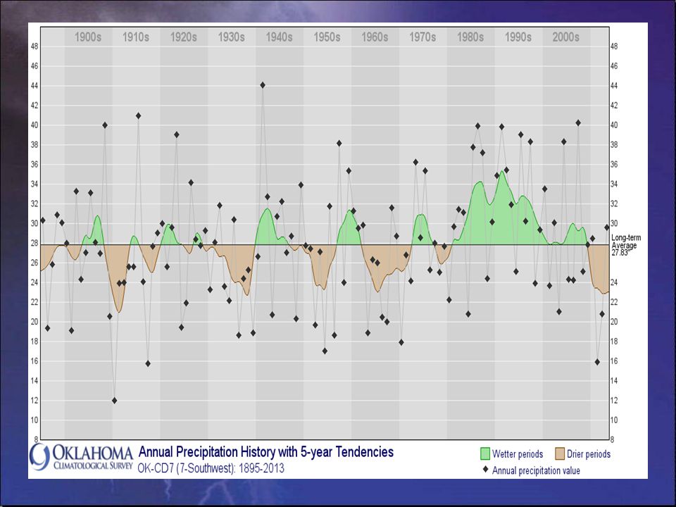
7
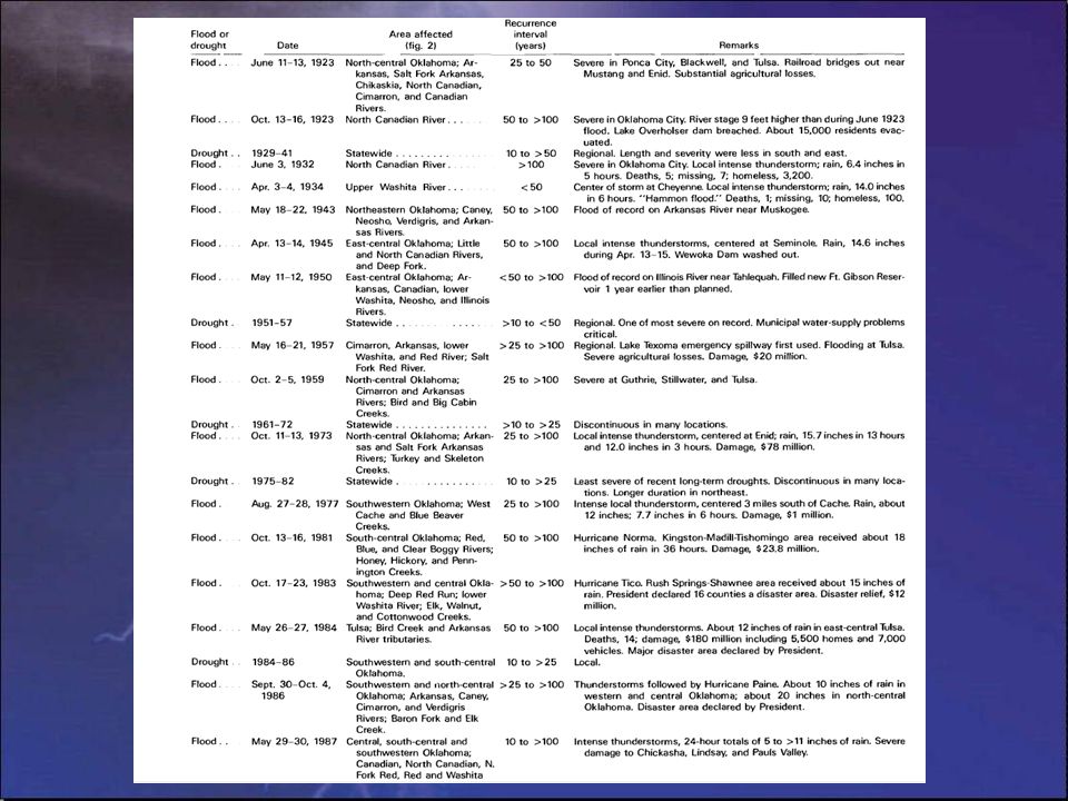
Lake Altus at Lugert, OK Top of Conservation Pool – 1559.0 feet Top of Flood Pool – 1562.0 feet May 19, 1951 – 1562.10 feet May 10, 1993 – 1561.55 feet August 4, 1995 – 1560.76 feet March 19, 1998 – 1561.64 feet June 22-23, 2007 – 1560.13 feet

8
April 3-4, 1934 Hammon Flash Flood

9
May 13-19, 1951 Heavy Rainfall and Flood Event

14
August 18-19, 2007 Remnants of Tropical Storm Erin Re-intensify over Oklahoma

16
Storm Total Rainfall

17
24-hour Rainfall Totals at 7 AM CDT on 8/19/2007

Similar presentations


 HWT-Hydro Testbed Experiment>")


 NRCS daily: 80 NRCS statistical: 78 Coordinated: 80 / 195% median.>")

