Download presentation
Presentation is loading. Please wait.

1
www.kimballcorp.com Click to edit Master title style Procedures to conduct Fuel Stockpile Inventories August 26, 2009 ARIPPA 19 th Annual Technical Convention

2
www.kimballcorp.com Items Covered Coal Pile Maintenance in Preparation for Stockpile Surveys Coal Pile Density Procedures Coal Pile Volume Procedures Summary and Questions

3
www.kimballcorp.com Efficient Management of Stockpiles Provide easy access to material Maximize load distance efficiency factor Attain stack/reclaim rates Meet blending requirements Maintain or improve uniformity, integrity, and quality Minimize manpower or equipment Safety Be able to deal with stockpile fires Reduce environmental impacts

4
www.kimballcorp.com Stockpile Delivery Methods Truck dump Rail dump Ship or barge unload

5
www.kimballcorp.com Coal on stockpile Delivered and stacked as cone Rate of delivery determines number or shape of cones Kidney shape with moving stackout Or multiple cones All cones need to be moved For more deliveries Safety improvement Segregation reduction to preserve quality

6
www.kimballcorp.com Kidney Stackout

7
www.kimballcorp.com Multiple cone stackout

8
www.kimballcorp.com Effects of Pile Conditions on Accuracy Windrows Gullies Inconsistent Uncompacted Compacted Coal quality Excessive cones

9
www.kimballcorp.com Working on pile

10
www.kimballcorp.com Methods to avoid so moisture not increased Large flat stockpiles that allow little, if any, runoff Possibility of ponding on surface Pushing coal through low areas that have standing water while unloading/reclaiming Ground water levels higher than the pile or pile base

11
www.kimballcorp.com Beneficial Practices in controlling moisture Keep stable side slopes, while increasing maximum height over smallest area Avoid flat tops Enhance runoff by compacting surface AND side slopes Allow good drainage of the pile Reduce moisture content of incoming coal

12
www.kimballcorp.com Pile construction by Rubber-tired

13
www.kimballcorp.com Improved conditions=improved accuracy More consistent density Less moisture variability Less water means easier to move and easier to burn Consistent quality Less chance for fire Smoother surface easier for volumetric calculations Better burn rates

14
www.kimballcorp.com What to do for improving pile conditions Work the pile in consistent pattern Don’t rush due to time or amount of delivery Eliminate gullies from erosion Eliminate windrows Compact consistently across the pile Reduce amount of loose coal in cones Keep berms to minimum

15
www.kimballcorp.com Conclusions - Questions

16
www.kimballcorp.com Coal Pile Density Procedures ASTM D6347 – Standard Test Method for Determination of Bulk Density of Coal Using Nuclear Backscatter Depth Density Methods

17
www.kimballcorp.com Methods for Stockpile Densities Nuclear Methods Depth Density Surface Direct Density Methods Shelby Tube Water-displacement Method Continuous Auger Sampling Method

18
www.kimballcorp.com Depth Density Procedures Nuclear Density Procedures Calibration Procedures CAST Method Procedures

19
www.kimballcorp.com Preparation of Access Holes Small – diameter Augers Split – spoon / hollow-stem augers Hydraulic Push

20
www.kimballcorp.com Installation of Access Pipe PVC Pipe small – diameter augers split – spoon / hollow-stem augers Steel Pipe hydraulic Push

21
www.kimballcorp.com Nuclear – depth density gauge Troxler Model 1351 Troxler Model 1352 CPN 501

22
www.kimballcorp.com Recording density counts Gamma readings Set of 2 each elevation Not a density YET!

23
www.kimballcorp.com Calibration of Nuclear gauge Same process Gamma readings Minimum 4 points ASTM is 8 points Linear regression Forcing curve to a line

24
www.kimballcorp.com

25
Direct Density Methods Sampler Different problems

26
www.kimballcorp.com Direct Density Methods Sampling interval Recovery of sample Weighing the sample Calculating the density

27
www.kimballcorp.com
28
Factors that effect density Access Sampling interval Recovery of sample Gauge stability Scale accuracy Calibration Calculations Stockpile condition Moisture Quality Pile construction

29
www.kimballcorp.com

30
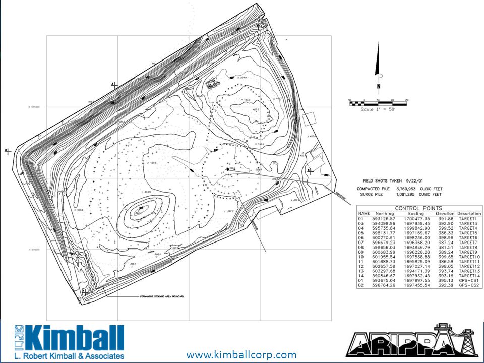
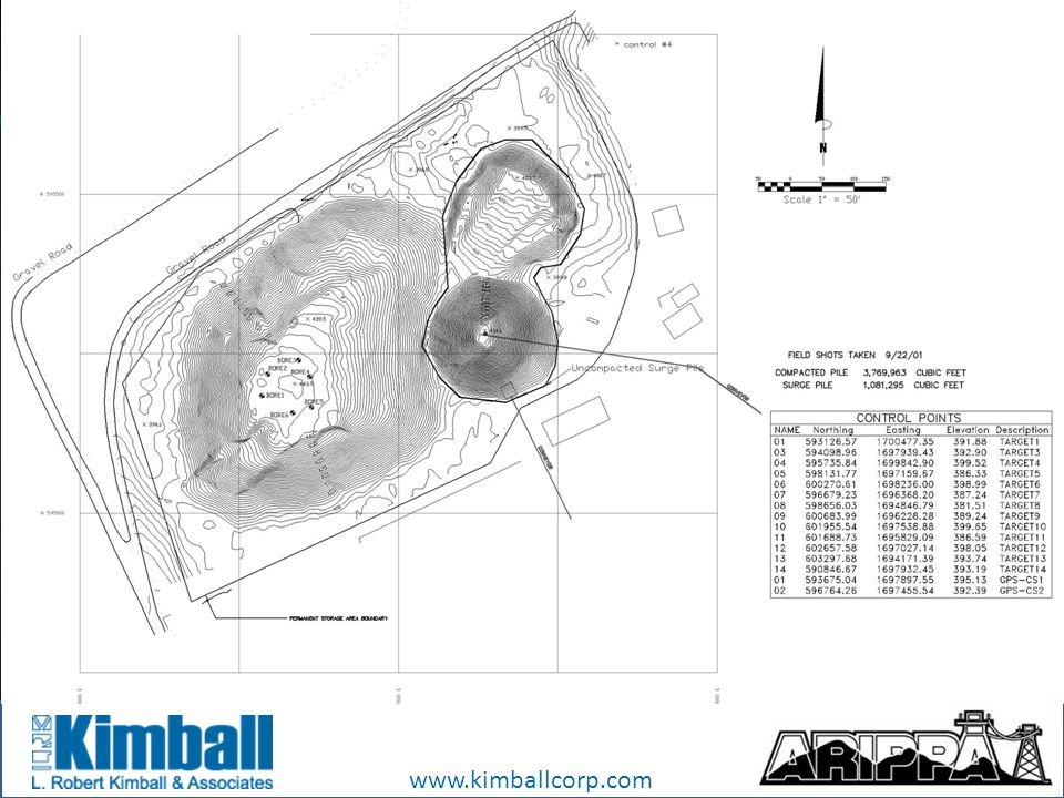
Coal Pile Volume Procedures ASTM D6172-98 (reapproved 2004) Standard Test Method for Determining the Volume of Bulk Materials Using Contours or Cross Sections Created by Direct Operator Compilation using Photogrammetric Procedures.
 Standard Test Method for Determining the Volume of Bulk Materials Using Contours or Cross Sections Created by Direct Operator Compilation using Photogrammetric Procedures.")
31
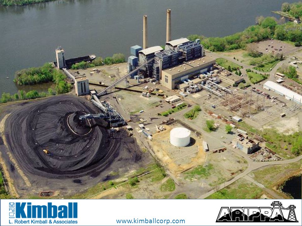
www.kimballcorp.com Introduction On a continuing basis, coal companies, power generating stations, quarries, aggregate suppliers, and other entities need to know how much material is contained in stockpiles at facilities such as mines, quarries, processing plants, generating stations, landfills and other storage sites. Through the use of aerial photography, ground control surveys, and photogrammetric processes, stockpiles can be mapped and the volume of an inventory area can be determined.

32
www.kimballcorp.com Introduction This work usually requires a quick turnaround from the initial flight until the final volumes are calculated. Many times the photography must occur on a certain date or within a specified period. Coal stockpiles are usually needed within a short period of time, since they may be needed on an end of month and a mid-month basis. Landfills and quarries are usually needed within a month of aerial acquisition. Weather is always a concern.

33
www.kimballcorp.com What is Topographic Mapping? All mapping techniques use data collection points to approximate the mapped surface. Aerial mapping uses photographic pairs to determine data collection points. Conventional surveying uses horizontal angles, vertical angles, and distances to determine data collection points.

34
www.kimballcorp.com What is Topographic Mapping? (continued) The more data points and the selection of the data points used, the greater the accuracy. It is therefore important to have a system that allows for a rapid collection of many data points and coverage for the entire mapped surface.
 The more data points and the selection of the data points used, the greater the accuracy. It is therefore important to have a system that allows for a rapid collection of many data points and coverage for the entire mapped surface..")
35
www.kimballcorp.com Using the data points collected Creating a digital terrain model (DTM) DTM is actually the collection of mass data points which include spot elevations, and break/fault lines. From this a triangulated irregular network (TIN) is generated. The TIN is then used to create contours.
 is generated. The TIN is then used to create contours..")
36
www.kimballcorp.com Calculating the volume To calculate the volume of data points collected you need to compare the base TIN file with the new TIN file. The base contour map is a digital file of the surface below the stockpile. The new contour map is a digital file of the data collected and calculated by the TIN. The difference of these two digital files is the volume of the stockpile.

37
www.kimballcorp.com

40
Basic Needs Aerial Imagery Horizontal and Vertical Ground Control Delineated Limits of Stockpile Base Map Data

41
www.kimballcorp.com Aerial Imagery

42
www.kimballcorp.com Ground Control

43
www.kimballcorp.com Stockpile Limits

44
www.kimballcorp.com Base Map

45
www.kimballcorp.com Base and Control Map

46
www.kimballcorp.com Control Map

47
www.kimballcorp.com Standards American Society of Testing and Material Standards American Society for Photogrammetry and Remote Sensing Standards National Map Accuracy Standards National Coal Weighing and Sampling Association Needs

48
www.kimballcorp.com Rockwell Shrike Commander Aerial Photography Aerial Photography Needs USGS Calibrated Aerial Camera Black and White or Color Film Contact Prints or Digital Files Film Diapositives or Digital Scans Photo Enlargements

49
www.kimballcorp.com Aerial photography camera

50
www.kimballcorp.com Photogrammetry The illustration shows how an aircraft flies along a flight line (represented on the ground by a dashed line in the illustration) and takes overlapping photographs. The dark gray area shows the overlap area.

51
www.kimballcorp.com Aerial Image

52
www.kimballcorp.com Aerial Image

53
www.kimballcorp.com Ground Control Permanent, Recoverable Horizontal and Vertical Positions are desired Minimum Four Points Photo Identifiable or Targeted XY Coordinate System: State Plane, or a Local Plant System. Vertical Control: North American Vertical Datum, or a Local Plant System

54
www.kimballcorp.com Ground Control Global Positioning System (GPS) is used to obtain the Ground Control for many projects today. However, some projects, such as stockpile inventories, often require more conventional methods due to the specific requirements of the project.

55
www.kimballcorp.com Ground Control Stockpile inventory mapping requires accurate points surveyed on the ground to ensure accurate mapping. In addition to photo identifiable points, they can be marked on the ground with plastic targets or markers that are visible in the aerial photographs.

56
www.kimballcorp.com Stockpile Limits and Base Map Stockpile limit Delineation by Client Photo Enlargements, Contact Prints or Digital Scanned Images are submitted for Client marking and verification Base Map Confirmation by Client Client provides Base Map, usually in Digital Format. If not in digital format, it will need to be digitized or created in a mutually acceptable method Aerial Photo of a Coal Mine with “Raw” and “Clean” Piles outlined.

57
www.kimballcorp.com

58
Photogrammetry Upon review and approval of (1) the aerial photography, (2) the ground control information, (3) the delineated stockpile limits, and (4) the digital base map data, the Digital Stereocompilation begins. The aerial photography is stereoscopically introduced to an Analytical Plotter or Digital Soft Copy Workstation. The ground control data is used to accurately orient the stereoscopic imagery and a photogrammetric solution is established for the data collection of the imagery. The Digital Stereo Mapping Technician compiles the required data according to the project specifications. The Technician collects necessary mass points and breakline data, sufficient to generate a Digital Terrain Model (DTM). The DTM is used to generate a TIN (Triangulated Irregular Network).
. The DTM is used to generate a TIN (Triangulated Irregular Network)..")
59
www.kimballcorp.com Photogrammetry The stereo technician is using the latest digital synthetic stereo viewing technology to view the overlap area in 3D. This technology allows her to digitally map the terrain in three dimensions.

60
www.kimballcorp.com Aerial Stereo Pair

61
www.kimballcorp.com 3D Imaging

62
www.kimballcorp.com Topographic Mapping

63
www.kimballcorp.com Volume Calculation To calculate the volume of the new stereo collected stockpile, the base elevation TIN file is compared with the new stereo compiled elevation TIN file. It is important that the new elevation data meets with the base file data at the toe of the pile. The difference of these two digital files is the volume of the stockpile. The volume is generated and a Report is prepared and delivered.

64
www.kimballcorp.com Summary Aerial Photography Ground Control Stockpile Limit Delineation Base Map Verification Photogrammetric Stereo Compilation Volume Determinations

65
www.kimballcorp.com Thank You Summary and Questions

Similar presentations