Download presentation
Presentation is loading. Please wait.

1
Rio Salado, Rio Salado Oeste Phoenix, Arizona Ecosystem Restoration Project H&H for Planners February 2011 Rio Salado, Rio Salado Oeste Phoenix, Arizona Ecosystem Restoration Project H&H for Planners February 2011 One Team : Relevant, Ready, Responsive, Reliable 1

2
Study Area ARIZONA Utah Nevada Colorado New Mexico Verde River Salt Phoenix Tucson Gila River Santa River Cruz Mexico California Colorado River Flagstaff Greater Phoenix, AZ Metropolitan Area and Salt River Project System Greater Phoenix, AZ Metropolitan Area and Salt River Project System Salt River Watershed 15,000 square miles Joins Gila River west of Phoenix Downtown Phoenix ( 19 th AVE to 83 rd AVE - 8 miles ) Other USACE Projects Tres Rios / Rio Salado / Va Shly’ay Akimel Salt River Watershed River Verde River Watershed Gila River Watershed
 Other USACE Projects Tres Rios / Rio Salado / Va Shly’ay Akimel Salt River Watershed River Verde River Watershed Gila River Watershed")
3
Study Area Tres Rios City of Phoenix Design and Construction Rio Salado Oeste City of Phoenix Feasibility Rio Salado Cities of Phoenix / Tempe Construction Va Shly’ay Akimel Salt River Pima Maricopa Indian Community City of Mesa PED Greater Phoenix, AZ Metropolitan Area and Salt River Project System Greater Phoenix, AZ Metropolitan Area and Salt River Project System

4
Postcard courtesy Susan Sargent 1890’s near 51 st Ave 2003 near 51 st Ave Historic Conditions Perennial stream Shallow groundwater Meandering channel Emergent wetlands Cottonwood - Willow Mesquite Study Area in 1937

5
Southwestern Riparian Trend 1850 2000 1940 Southwest increasingly urban Arid Southwest riparian ecosystem habitat = critically endangered Cottonwood-willow riparian forest = most threatened ecosystem in the Nation ( Nature Conservancy ) 90 % loss in functional habitat
 90 % loss in functional habitat")
6
Existing Conditions River Bottom / Native Sand / Gravel Operation Agricultural

7
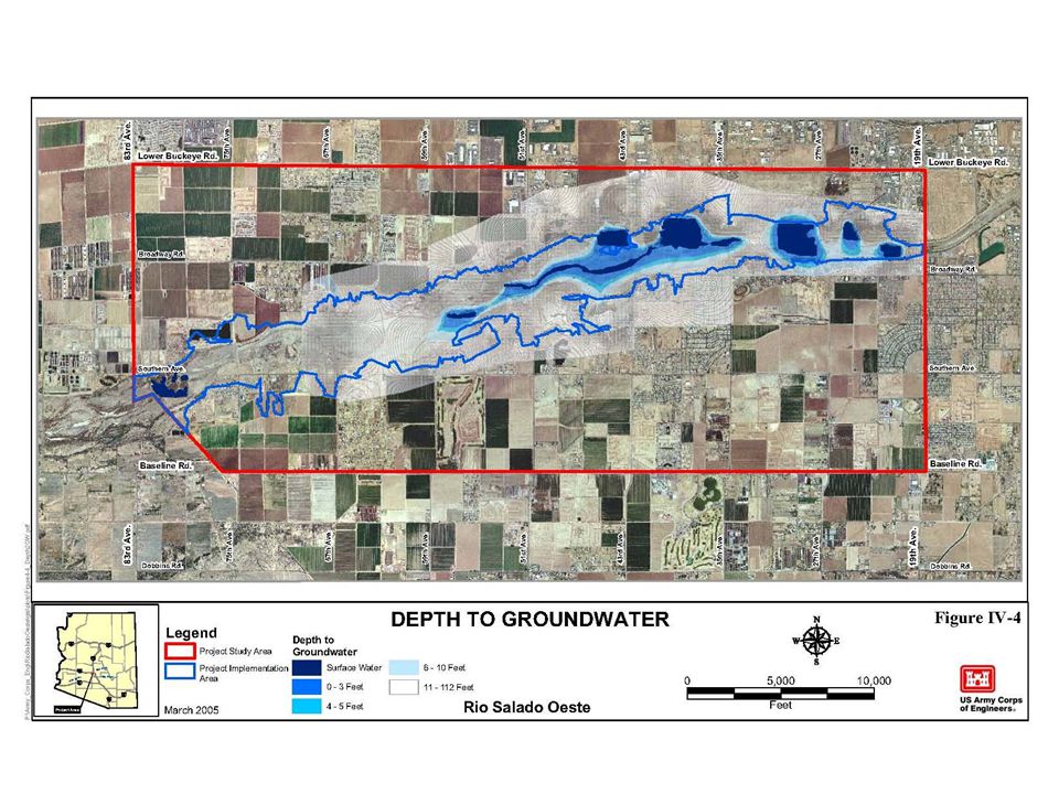
Project Area Baseline Road Lower Buckeye Road 83 rd Avenue 19 th Avenue 100-year Flood Plain 1 1 2 2 3 3 0 0 Miles

9
9 Habitats Riparian habitats reduced. Biota Native vegetation Reduced/eliminated Geomorphology Floodplain altered Connectivity reduced Water Quality H&H Perennial water Flow eliminated Groundwater Lowered Physical & Chemical Processes Habitat & Biota Conceptual Model From Feasibility Report, Appendix A, pg 13 Currently, the Salt River is characterized as an effluent-dominated water course where highly disturbed marginal riparian habitat only occurs at locations where wastewater effluent and nuisance water runoff are discharged into the channel. The remainder of the habitat is so disturbed that most of the channel is devoid of vegetation and consists of a barren cobbly wash. Stressors: Urbanization Channelization Gravel Mining Stressors: 6 Storage Dams Irrigation Diversion Agriculture Stressors: Invasive Salt-Cedar Vegetation Clearing

10
10 Goal – provide diverse habitat types that naturally occur in a Sonoran desert riparian system. ObjectiveHabitat TypeCriteria Restore riparian habitat including: Mesquite Mesquite Habitat is found on upper terraces of floodplain, above the active channel (low water demand). Cottonwood/willow Cottonwood and Willow Habitat is found along river banks or at approximately the 2 year flood level (moderate water demand) Wetland Marsh Wetland-Marsh Habitat is found at the lowest elevations in shallow ponds or saturated soils (high water demand) Aquatic Strand/Scrub Aquatic Strand/Scrub Habitat is found in the channel and along the channel border (high water demand Open water
. Cottonwood/willow Cottonwood and Willow Habitat is found along river banks or at approximately the 2 year flood level (moderate water demand) Wetland Marsh Wetland-Marsh Habitat is found at the lowest elevations in shallow ponds or saturated soils (high water demand) Aquatic Strand/Scrub Aquatic Strand/Scrub Habitat is found in the channel and along the channel border (high water demand Open water.")
11
11 Model used during planning –H&H: HEC-RAS for water surface profiles, bridge scour –Geomorphology: Stable-channel approach initially used (EM 1110-2-1418, 1994) Sediment Transport: Used HEC-6T to predict scour or deposition over a 25 year period Scour: Used HEC-RAS and Federal Highways guidelines –Water Quality: None –Vegetation: None, though an HGM type of philosophy was used. –Biota (Ecological Response) HEP
 HEP.")
12
12 Factor consideredDesign Considerations River Function Habitat Bank Stability Flood Impacts Groundwater Other In an urban, high energy setting, river function had to be modified based on habitat, bank stability, and flooding concerns. One of the goals was to design a low flow channel having “soft sides and bottom” that would convey the design discharge of 12,200 cfs. Stage-discharge-frequency relationship had to provide conditions favorable to floodplain vegetation with occasional flushing of floodplain during larger flood events. Irrigation water is needed to get floodplain vegetation started. Bank erosion and channel migration had to be limited No change in 100-year flood elevation. Overbank “n” increased to check sensitivity To meet NPDES requirements, salinity levels must be kept low so that native trees aren’t impacted. Operations must not cause groundwater migration and bank erosion must be kept to a minimum especially in the vicinity of 13 existing landfills FAA had 10,000 foot open water constraint to prevent attracting waterfowl and larger birds Formulate Alternative Plans

13
Recommended Plan - Alt 5A Acres Restored Cottonwood - Willow ( 375 ) Mesquite ( 417 ) Wetlands ( 190 ) Riparian Scrub ( 296 ) Scrub shrub ( 56 ) Channel ( 170 ) Water supply ( Storm water / effluent ) River channel restored Revegetation Invasive species removed Gravel pits restored ( in floodplain ) BeforeAfter (Rio Salado Examples)
 Mesquite ( 417 ) Wetlands ( 190 ) Riparian Scrub ( 296 ) Scrub shrub ( 56 ) Channel ( 170 ) Water supply ( Storm water / effluent ) River channel restored Revegetation Invasive species removed Gravel pits restored ( in floodplain ) BeforeAfter (Rio Salado Examples)")
14
14 Habitats Riparian habitat Channel habitat Wetlands Biota Cottonwood/Willow Mesquite Wetlands Riparian Scrub Geomorphology Channel restored Floodplain restored Water Quality H&H Increased soil moisture Low flow channel Physical & Chemical Processes Habitat & Biota Conceptual Model Actions: Channel Restoration Gravel Pits Restored Grade Control Actions: Water Supply from Storm Water Effluent Actions: Native Veg. Planting Invasive Removal

15
Recommended Plan - Alt 5A Baseline Road Lower Buckeye Road 83 rd Avenue 19 th Avenue 100-year Flood Plain 1 1 2 2 3 3 0 0 Miles Channel Restoration ( 170 acres ) Cottonwood – Willow ( 375 acres ) Mesquite ( 417 acres ) Emergent Wetlands ( 190 acres )
 Cottonwood – Willow ( 375 acres ) Mesquite ( 417 acres ) Emergent Wetlands ( 190 acres )")
16
Recreation Plan Baseline Road Lower Buckeye Road 83 rd Avenue 19 th Avenue 100-year Flood Plain 1 1 2 2 3 3 0 0 Miles P P P P P Channel Restoration ( 170 acres ) Cottonwood – Willow ( 375 acres ) Mesquite ( 417 acres ) Emergent Wetlands ( 190 acres ) Multi-Purpose Trail ( 14 miles ) Walk – In Access Points ( 5 ) Parking / Access Points ( 5 ) P
 Cottonwood – Willow ( 375 acres ) Mesquite ( 417 acres ) Emergent Wetlands ( 190 acres ) Multi-Purpose Trail ( 14 miles ) Walk – In Access Points ( 5 ) Parking / Access Points ( 5 ) P")
17
Revegetation Cover Type Acres Cottonwood - Willow ( 375 ) Mesquite ( 417 ) Wetlands ( 190 ) Riparian Scrub ( 296 ) Scrub shrub ( 56 ) Revegetation with native species at appropriate sites throughout project area. Rio Salado 2003 Rio Salado 2005 Rio Salado 2007

18
Gravel Pits 27 th and 37 th Avenues Reshaping/cut and fill ~3M cy Tie into channel/floodplain

19
Channel Restoration Grading/Terracing within 10 yr 20,200 cfs design discharge Cut/Fill 660,000 cubic yards Grade Control at 35 th Avenue Bridge Restored river channel similar to historical channel

Similar presentations