Download presentation
Presentation is loading. Please wait.

1
Biodiversity Project Manager Warwickshire Habitat Biodiversity Audit
Developing Nature Improvement Areas in Warwickshire – bigger, better and connected Local Wildlife Sites and Connectivity Mapping Chris Talbot Biodiversity Project Manager Warwickshire Habitat Biodiversity Audit

2
Local Wildlife Sites Areas carefully identified and selected for their special wildlife habitats - ‘County importance’ The best natural places in everyone’s neighbourhood – ‘Local’ Form a network of our most valuable urban and rural areas for the natural environment Complementary to statutory designations such as SSSIs and LNRs Afforded protection through the planning system (but non-statutory) Perform a crucial role in protecting our natural environment
 Perform a crucial role in protecting our natural environment.")
3
Statutory wildlife sites in Warwickshire
13 Local Nature Reserves (LNR’s) 57 SSSI’s 1 Special Area of Conservation (SAC) - Ensor’s Pool Collectively cover 0.7% Warwickshire sub-region National figure is 6.8% Local Wildlife Sites cover 2.71% Warwickshire sub-region
 57 SSSI’s. 1 Special Area of Conservation (SAC) - Ensor’s Pool. Collectively cover 0.7% Warwickshire sub-region. National figure is 6.8% Local Wildlife Sites cover 2.71% Warwickshire sub-region.")
4
Warwickshire Local Wildlife Sites project
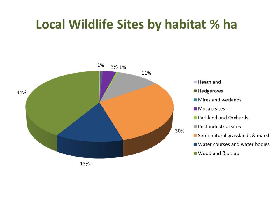
Guidance for Non-Statutory Sites of Importance for Nature Conservation (SINCs) in Warwickshire - May 1998 formalised into the Local Wildlife Sites Project (LWSP) as part of the HBA in 2000 range in size from less than 1 hectare to over 120 hectares cover 13 wildlife habitat types from canals to woodland and scrub include churchyards, road verges, ponds, meadows, disused railway lines, orchards, rivers, quarries etc.. occur on publicly and privately owned land, urban and rural Incorporated into the LBAP habitat plans PPS9 – clear duty on local planning authorities to ensure protected species and habitat in the uk – “material consideration” in planning applications NI197 – Indicator of performance of Las for biodiversity and ensuring effective conservation management for local sites. NPPF replaces PPS9 retains the distinction between hierachy recognises local sites for their importance to wider ecological networks, requires LA to set out stratgic approach to local plan and to plan positively for creation/enhancement and management of network biodiversity and green infrastructure
 in Warwickshire - May formalised into the Local Wildlife Sites Project (LWSP) as part of the HBA in range in size from less than 1 hectare to over 120 hectares. cover 13 wildlife habitat types from canals to woodland and scrub. include churchyards, road verges, ponds, meadows, disused railway lines, orchards, rivers, quarries etc.. occur on publicly and privately owned land, urban and rural. Incorporated into the LBAP habitat plans. PPS9 – clear duty on local planning authorities to ensure protected species and habitat in the uk – material consideration in planning applications. NI197 – Indicator of performance of Las for biodiversity and ensuring effective conservation management for local sites. NPPF replaces PPS9 retains the distinction between hierachy recognises local sites for their importance to wider ecological networks, requires LA to set out stratgic approach to local plan and to plan positively for creation/enhancement and management of network biodiversity and green infrastructure.")
7
Proportion of Local Sites in positive conservation management – defra 2012

8
Tame Valley Local Wildlife Sites
Status Count Area in ha deferred 2 10.13 destroyed 4.53 LWS 24 362.18 potential site 34 572.51 rejected 8 43.33 Total 70 992.68

9
Coombe Abbey Local Wildlife Site SP37Z2
Designated 21/09/2010 Area ha Habitats: Wet woodlands Dry woodlands Acid grasslands Neutral grassland Open water Rare Flora Sanicle Large Bittercress Hard shield-fern Narrow Buckler-fern Black Poplar Rare Fauna Spotted Flycatcher Marsh Tit Lesser Spotted Woodpecker Beeflies Nomad Bees

10
Grange Farm Moat Meadows LWS
Dordon Spoil Heap LWS Wappenbury Wood LWS

11
Warwickshire’s habitat Connectivity mapping
Joint project WBRC, York University and HBA Woodlands Hedgerows Grasslands Wetlands Habitat Biodiversity Audit

12
Connectivity modelling
Designed for highly fragmented habitats Applied to different types of habitat e.g. woodlands, grasslands, wetlands. Key components of the model are the quality, size, shape and type of patch (habitat) Requires GIS mapping to extract habitat data and interpret results LWS information and Phase 1 habitat mapping is ideally suited to applying the model because of the detail and quality of the data
 Requires GIS mapping to extract habitat data and interpret results. LWS information and Phase 1 habitat mapping is ideally suited to applying the model because of the detail and quality of the data.")
13
Applying connectivity
Identifying strategic areas for wildlife – forward planning Incorporating connectivity into local plans – Lawton report recommendations Delivering Living Landscapes initiatives through habitat connectivity Individual species connectivity e.g. bats, butterflies, dormice, water voles etc.

14
The Lawton Report Bigger Better Connected Put the Right Habitat in the
Right Place Making Space for Nature: a review of England’s wildlife sites and ecological networks: defra 2010

15
Incorporating connectivity mapping into local plans
Stratford-on-Avon District Council- Ecological Study of Local Service Villages July 2012 Warwick District Council - Landscape Sensitivity and Ecological & Geological Study November 2013 Nuneaton and Bedworth Borough Council – Ecology and Geodiversity Assessment April 2014

16
Delivering living landscapes initiatives Princethorpe project
Conservation measures hedgerow gap reduction and hedge row creation tree plantation - infilling

17
Species connectivity: Barbastelle bat study Whichford Wood
Conservation measures retention and management of key woodlands, flight-lines and foraging areas hedgerow creation - connectivity small linear woods field margins wet meadows

18
Conclusions Local wildlife sites make a valuable contribution to wildlife conservation in Warwickshire They do require protection where ever possible Difficult to determine their condition and continuing management for wildlife Good habitat data and connectivity mapping is the basis for delivering living landscapes LWS are the building blocks for living landscapes More research opportunities and applications in applying connectivity

19
Thank you

Similar presentations


 Good examples of BAP delivery as part of development in Northamptonshire Rachel Gorman Team Leader.>")


>")


>")

