Download presentation
Presentation is loading. Please wait.

2
A violently rotating column of air extending from a thunderstorm to the ground. Wall cloud Funnel cloud Suction Vortices (Vortex)
.")
4
Conditions that must be present for Tornado formation: -Cool, dry air colliding with warm, moist air. Conditions that signal a Tornado are: - Greenish clouds - Hail - Rotation - Funnel clouds - Sounds like a freight train

5
Where are they found Tornadoes result from the interaction of contrasting air masses, mainly found in mid- latitude regions where tropical and polar air meet as part of the global atmospheric circulation. Tornadoes are the most violent atmospheric storms, although the damage is high, the area affected is much smaller.

7
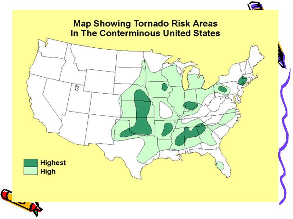
Where are tornadoes most likely to happen? Tornado Alley Tornado Alley is an area in the great plain states that runs from Texas to Nebraska+. Between the Rocky mountains and the Appalachian mountains. On both sides of the Mississippi river. -As well as some of the southern states, and many parts of the world. -They occur mostly in the afternoon and in the early evening.

9
Tornadoes can actually occur at any time of the year, but peak tornado season is March thru May for the Southern states and in the northern states it is during the summer

10
formation Supercell formation Non-supercell formation Dry line formation

11
Consist of 5 stages Stage One: The dust, whirlwind stage Stage Two: Organizing Stage. Stage Three: Mature Stage. Stage Four: Shrinking Stage. Stage Five: Decaying Stage.

12
Where does the energy come from Latent heat Latent Heat of Condensation is the main energy source for the Thunderstorm and Tornado. When the water vapor inside the storm condenses it releases the heat it used when it evaporated. When this latent heat warms the rising air parcel, it can create such high velocities that a Tornado is formed.

13
How are tornadoes categorized In 1971, Dr. T. Theodore Fujita devised a six category scale to classify Tornadoes, known as the Fujita Tornado Scale. How the scale works is, it is based upon the maximum wind speeds inside the funnel. They can tell the wind speeds by investigating each Tornado to measure the damage and match it to what the scale says.

14
F0 -F1 Weak Tornado F2 -F3 Strong Tornado F4 -F5 Violent Tornado

15
Case study: the Oklahoma tornadoes, May 1999 In May 1999 a swarm of 65 tornadoes occurred along a 150-mile belt running from the south-west of Oklahoma State towards Kansas. 45 people dead 8000 buildings ruined or damaged A large 1-2km wide tornado touched down for a track over 61km long including parts of Oklahoma city was the first tornado cause one billion dollars worth of damage.

18
Ideal conditions in the Great Plains for tornado information Warming moist air from Gulf of Mexico Cool drier air on top of the warm air, leading to instability Separation layer of warm dry air so that the two main layers do not mix Wind shear at upper levels A clear frontal boundary between two contrasting air masses Rotation in the jet stream

19
The tornadoes were huge, visible and audible Local radio and television gave huge coverage Warning from the National Weather Service (NWS) gave an average lead time of Oklahoma City of 32 minutes. This is twice the normal time. Warning have improved with the use of Doppler radar which can detect wind changes. The SPC gave early alerts

20
The Tri-State tornado of March 18th, 1925 was the deadliest tornado killing 689 people in Missouri, Illinois, and Indiana. The Tri-State tornado outbreak was quite deadly, but the costliest, biggest and most prolific outbreak was the April 3 rd & 4 th outbreak of 1974. This system spawned 148 tornados in a 16 hour period in 11 states. 30 of these tornados caused at least F4 damage and at one time 5 large tornados were on the ground.

21
It killed 315 people and injured more than 6140. It also caused 600 million dollars in damage. The hardest hit states were Alabama, Kentucky and Ohio. The most notable one was the tornado that hit Xenia, Ohio. It destroyed half the town, caused 100 million dollars in damage and killed 34 people.

23
The lifting force can cause train carriages being moved hundreds of meters. Tornado passes over a building the outside pressure is up to 200mb lower than that inside, explosion effect on the building. Damage from high wind speeds

24
People and animals can be appear to be burnt due to the rapid dehydration resulting from the pressure fall. The resultant flying objects and debris

25
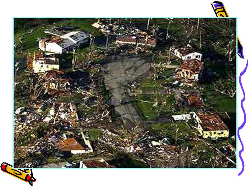
-The damage path of a Tornado can be anywhere from a single spot to 160+ km. -They are capable of: Toppling buildings lifting mobile homes and cars hurling: -people -animals -trees -debris for hundreds of yards.

27
The destructive effects of tornadoes due to the high wind speeds the lifting force of the funnel wall The abrupt change in atmospheric pressure.

28
On average 800 Tornadoes occur every year. 80 deaths 1500 injuries Of all Tornadoes: 69% weak 29% strong 2% violent Tornadoes can be on the ground for an instant to several hours, but the average time is 5 minutes.

29
-Average width of a tornado can range from 10 meters to 1.6km+. Typically they are 50meters wide. -Tornadoes can move at about 16-96+ mph, but the average is 16-32 mph. -Average Tornado moves from southwest to northwest.

30
Hazard-resistant design Requiring solid construction of buildings Using basements as part of the structure Modify people ’ s vulnerability Prediction (using radar and satellite technology) Warning Community preparedness Share the loss
 Warning Community preparedness Share the loss")
31
Prediction and forecasting The first Tornado forecast found in 1948, by using Surface and Upper air data along with similarities of the Tornado that struck a few days before they were able to correctly predict the occurrence of a Tornado. Today we use observations, numerical forecast models, Doppler Radar, weather balloons and Satellites to predict our weather. The biggest method being Doppler Radar, which uses the shifting of wavelengths of the waves emitted to determine the movement of clouds and all particles inside.

33
Victoria Bishop, Hazard and Responses Second Edition 2001 http://orca.rsmas.miami.edu http://weather.about.com

Similar presentations


 in contact with the ground and a cumulonimbus cloud Tornadoes are capable of inflicting.>")


>")


