Download presentation
Presentation is loading. Please wait.

1
Layout

2
Soil Texture

3
Describe Topography

4
Topography Maps

5
Slope Limitation Allowable Slope –depends on profile (low, standard high), span length, pipe diameter, and tire size – range 7% to 18% Crop clearance Slope absorption Pivot Flex
, span length, pipe diameter, and tire size – range 7% to 18% Crop clearance Slope absorption Pivot Flex")
6
Slope Adsorption Crop Clearance

7
Map Out Obstacles and Field Shapes

10
Applying Irrigation Water in Circles (vs. squares) In a rectangular system each sprinkler applies water to an Identically sized Area (A) In a circular system the area increases as the radius increases Hence, each sprinkler applies water to a differently sized Area (A) 1 243 1432 A1 = A2 = A3 = A4 A1 < A2 < A3 < A4
 In a rectangular system each sprinkler applies water to an Identically sized Area (A) In a circular system the area increases as the radius increases Hence, each sprinkler applies water to a differently sized Area (A) A1 = A2 = A3 = A4 A1 < A2 < A3 < A4.")
11
Methods of calculating area

12
Circle Area Computations Area = π R 2 Radius (ft.) Total Area (acres) Spoke Area (acres) 1301.2 2604.93.7 39011.06.1 52019.58.5 65030.511.0 78043.913.4 91059.715.8 104078.018.3 117098.720.7 1300121.823.1 Counting circles or dots Sprinklers are sized appropriately along length of pivot to maintain uniform applications along linear length of the center pivot machine
 Total Area (acres) Spoke Area (acres) Counting circles or dots Sprinklers are sized appropriately along length of pivot to maintain uniform applications along linear length of the center pivot machine")
13
Equations

14
Effective Radius The effective radius of the end gun is only 75 to 80 percent of the wetted radius

15
Other GIS GPS Cad Surveying

16
Class Exercise

17
Problem 1 A pivot has the last sprinkler at 1300 ft and the sprinkler has a throw of 55 ft What is the effective wetted radius and the irrigated area?

18
Problem 2 A pivot with radius of 1295 ft has an end gun with the effective radius of 85 ft to water the corners. The end gun operates 50% of the time. Find the irrigated area?

19
Problem 3 A part circle with radius of 1350 ft irrigates all but 30 degrees of the circle. What is the irrigated area?

20
FULL CIRCLE WITH CORNER SYSTEM " L R $ H H For Example if the Angle during full Corner Extension is 14.7 degrees, L = 1295 ft, R = 1636 ft and H = 2000 ft. a Problem 4

21
Identify Source of Water Water Rights Surface, well? Screening requirements Quality (I.e., salinity)
.")
22
Well Filtering - sand Quantity Water level - drawdown

23
Surface Water Filtering Storage – quantity Storage - disposal

24
Water Quality Salinity, pH, calcium, iron, carbonate, sulfates Leaf burn Sealing Waste disposal –Smell and pathogens –Salts –Regulations

25
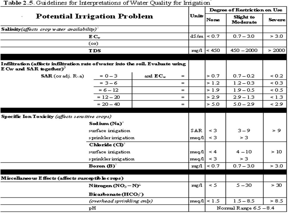
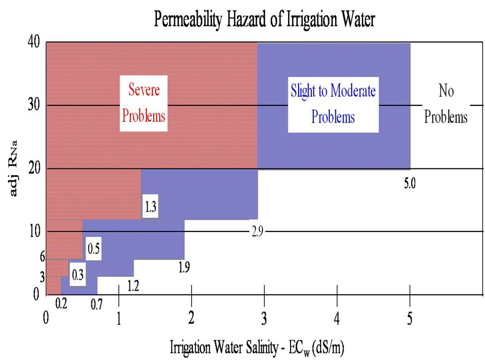
Salinity Hazard Salinity C-1, Low Salinity Water can be used for irrigation with most crops on most soils with little likelihood that soil salinity will develop. Some leaching is required, but this occurs under normal irrigation practices, except in soils of slow and very slow permeability. C-2, Medium Salinity Water can be used if a moderate amount of leaching occurs. Plants with moderate salt tolerance can be grown in most cases without special practices for salinity control. C-3, High Salinity Water cannot be used on soils with moderately slow to very slow permeability. Even with adequate permeability, special management for salinity control may be required and plants with good salt tolerance should be selected. C-4, Very High Salinity Water is not suitable for irrigation under ordinary conditions, but may be used occasionally under very special circumstances. The soils must have rapid permeability, drainage must be adequate, irrigation water must be applied in excess to provide considerable leaching, and very salt-tolerant crops should be selected. Sodicity S-1, Low Sodium Water can be used for irrigation on almost all soils with little danger of the development of harmful levels of exchangeable sodium. S-2, Medium Sodium Water will present an appreciable sodium hazard in fine-textured soils, especially under low leaching conditions. This water may be used on coarse textured soils with moderately rapid to very rapid permeability. S-3, High Sodium Water will produce harmful levels of exchangeable sodium in most soils and requires special soil management, good drainage, high leaching, and high organic matter additions. S-4, Very High Sodium Water is generally unsatisfactory for irrigation purposes except at low and perhaps medium salinity.

28
Identify the Power Source

29
Fuel Type of fuel Location –Of power source –Distance to pivot

30
Correct Phase

32
Practice Session for Design Project

33
Design Project Select Layout Determine irrigated area Select management soil

Similar presentations