Download presentation
Presentation is loading. Please wait.

1
South America Remote Sensing Data Integration
Based in Web GIS for Environmental Applications and Severe Storm Warning Luiz Augusto Toledo Machado Carlos Frederico Angelis Sérgio Pereira Fabiano Morelli Instituto Nacional de Pesquisas Espaciais Centro de Previsão de Tempo e Estudos Climático

2
Outcome The importance of Environmental Information for South America
The INPE/CPTEC Weather and Environmental Satellite Products Data Integration : The weather radar example The Geographical Information System for Environmental Applications The Virtual Lab for Training The RARS (Regional ATOVS Retransmission System) The GEONETCast applications for and by Developing Countries
 The GEONETCast applications for and by Developing Countries.")
3
South America: region of physical and social contrasts
Industrial area Agriculture Rain Forest Semi arid Fire Flood Drought Landslide Storms Lightning Severe wind Hail etc.

5
Examples of Images Infravermelho Vapor d´água Visível
Infravermelho com reace de nuvens frias Composta RGB Infravermelho e Visível

6
Real Time Precipitation Estimation Using GOES 10

7
Number of Days Without Rain Accumulated rainfall in the last 30 Days

8
UV INDEX

9
Fire Detection Using NOAA,MODIS,MSG,GOES-10

10
Fire Risk for South America

11
GOES-10 Satellite Winds – Images and Bufr format

12
Lightning – Information on Line

14
WEATHER RADAR DATA INTEGRATION

15
DATA AVAILABLE ON LINE

16
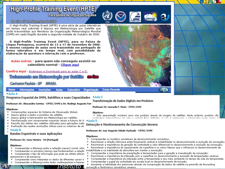
What is necessary to the information be useful and reach the stakeholders and end - users
Data Integration - same format and measurements procedures Have information with quality, without latency and a reliable flux of data (operational) Software based in GIS – friendly use and open source Training, Data Utilization and Support – low cost – Teletraining
 Software based in GIS – friendly use and open source. Training, Data Utilization and Support – low cost – Teletraining.")
17
Centro de Previsão de Tempo e Estudos Climáticos Weather Forecast and Climate Studies Centre CPTEC
The amount of daily data produced, together with environmental, social, economical and other information require advanced techniques to manipulate and make them available to users. A web based GIS is the ideal tool to facilitate handling information by users

18
SIGMA: GIS for Environmental Applications

19
SIGMA: GIS for Environmental Applications
Radar data

20
SOS: Severe Weather Observation System
The use of nowcasting together with SIGMA allows the monitoring of severe weather conditions and emission of alerts when a critical situation is detected.

24
R A R S – South America . Regional ATOVS Retransmission System
Main Goal – Decrease latency time for data assimilation in numerical weather prediction models Data Integration - Effort .

25
Regional Requests Run the simplified AAPP SOFTWARE at each site for each NOAA satellite passage Prepare the NOAA ATOVS 1C data and send to regional center Regional Center make available in near real time the ATOVS level 1C in BuFr format to all user by DVB, Internet or GTS

26
NOAA Reception Station
Fortaleza (Funceme) Natal (Marinha /UFRN) Cachoeira Paulista (INPE) Rio de Janeiro (Marinha, COPPE) Brasília (INMET) Cuiaba (INPE) Manaus (SIVAM) CHILE: Santiago Punto Arenas Antártida ARGENTINA: Villa Ortuzar (Buenos Aires) CONAE (Córdoba) Marambio (Antártida) Two Pilots Projects in Brazil (4 Satellite Stations) In Argentina (3 Satellite Stations)
 Natal (Marinha /UFRN) Cachoeira Paulista (INPE) Rio de Janeiro (Marinha, COPPE) Brasília (INMET) Cuiaba (INPE) Manaus (SIVAM) CHILE: Santiago. Punto Arenas. Antártida. ARGENTINA: Villa Ortuzar (Buenos Aires) CONAE (Córdoba) Marambio (Antártida) Two Pilots Projects. in Brazil (4 Satellite Stations) In Argentina (3 Satellite Stations)")
27
Project Proposal - DevCoCast GEONETCast applications for and by Developing Countries.
The proposed DevCoCast project will test the GEONETCast concept by Broadcast South-American local data to other regions in South-America. -SAMERICast Broadcast African local data to other regions in Africa - AFRICast Broadcasting the VGT4AFRICA data to South America - VGT4SAMERICA Broadcasting the YEOS data to ASIA - YEOSCast Broadcasting the AFRICA-GOOS data to Africa - ChloroCast Geert Borstlap VITO - Flemish Institute for Technological Research TAP - Centre for Remote Sensing and Atmospheric Processes

28
INPE DATA DISSEMINATION

29
Conclusion There is a broad range of societal benefits by using Environmental Information The information is available to be used. There is capacity building structure available to help improving the societal benefits Is very difficult to integrate the information available inside the same country or between different countries The users don't know how to use the information. The data dissemination system need to be improve and broadly used. The ambition is to embed the enviromental data in systematic local and national planning and decision making processes

Similar presentations


 INPE/INMET Brazilian Institute for Space Research National Institute of Meteorology Sérgio de.>")


 Instituto Nacional de Pesquisas Espaciais (INPE) 1 st EUROBRISA.>")


 December 2013, GEONETCast Virtual.>")


 of Belize is a small department within the Government of Belize that.>")