Download presentation
Presentation is loading. Please wait.

1
Responsible Use of Resources

2
Downtown Oak Hill

3
TxDOTs Proposed Super Highway

5
TxDOTs Vision for Oak Hill

6
Oak Hill

7
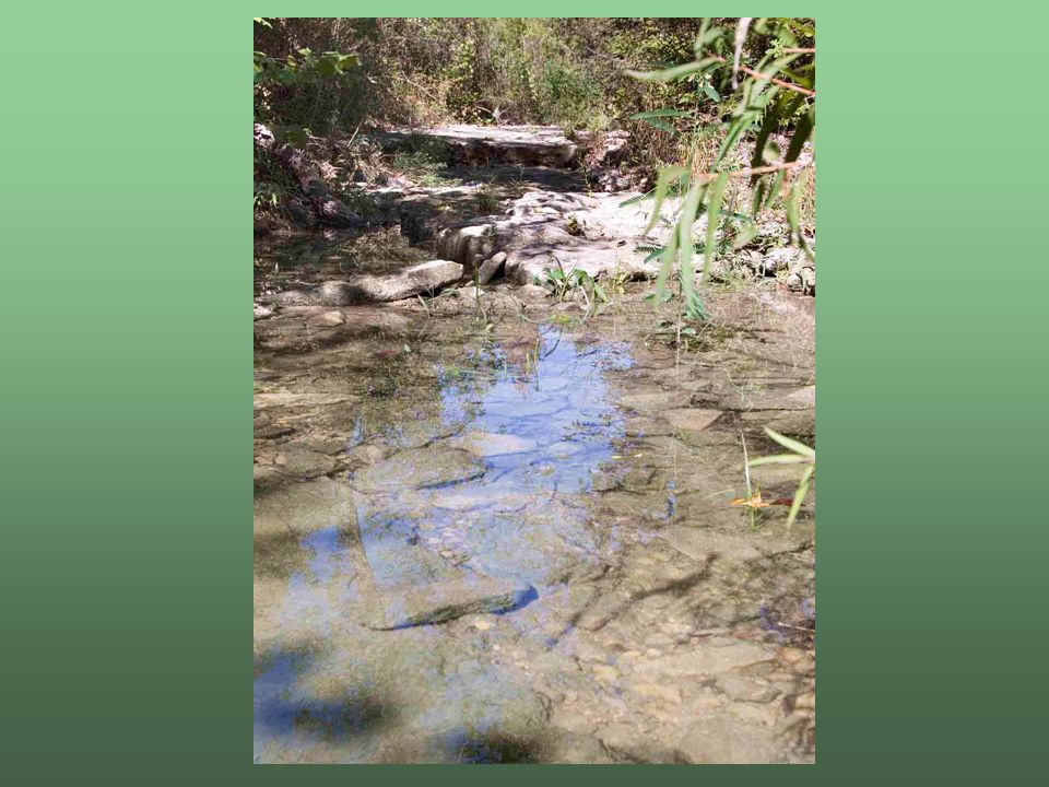
Williamson Creek

8
Fix290 Concept

9
Independent Consultant Smart Mobility, Inc. 18 States 4 MPOs Focused on developing alternatives that meet both transportation needs and community goals

10
Fix290 Meets CAMPO 2030 CAMPO is Capital Area Metropolitan Planning Organization and they are responsible for telling TxDOT what to do. The CAMPO 2030 plan is the transportation planning document that looks into the future (to the year 2030) to determine how our transportation systems should be built. The SMI report Quotes: Using guidelines in the Highway Capacity Manual, and accepted traffic engineering practices for determining conceptual design, the proposed 8 lane parkway can provide sufficient capacity for the projected year 2030 traffic volumes in the CAMPO model for 290 to operate at Level of Service D/E.
 to determine how our transportation systems should be built. The SMI report Quotes: Using guidelines in the Highway Capacity Manual, and accepted traffic engineering practices for determining conceptual design, the proposed 8 lane parkway can provide sufficient capacity for the projected year 2030 traffic volumes in the CAMPO model for 290 to operate at Level of Service D/E..")
11
TxDOT Level of Service C?

12
If any part of the system fails, the whole system fails.

13
TxDOT Causes Local Congestion (From the SMI report) The proposed TXDOT toll plan will bring high levels of congestion to both local residents making short trips on the frontage roads, and to commuters wishing to avoid tolls. Facilities with express toll lanes that are paralleled by free facilities (in this case the Frontage Roads) can lead to severe congestion on the free facilities, as many people will seek to avoid paying tolls and instead tolerate the congestion. Tolled facilities that are immediately paralleled by free facilities are generally used very lightly through most of the day, and only see heavy use during peak hours, when the free lanes will be severely congested. …Finally, it also means that the frontage roads will become significantly congested with traffic using them to avoid paying tolls, which will affect all local traffic as well. It is very possible that the express toll lanes, while providing a congestion-free route for those willing to pay, will create high levels of congestion on the frontage roads. Unless street connectivity in the Oak Hill area is improved, most local trips will also require use of the congested frontage roads, and most local traffic will be burdened by this increased congestion.
 can lead to severe congestion on the free facilities, as many people will seek to avoid paying tolls and instead tolerate the congestion. Tolled facilities that are immediately paralleled by free facilities are generally used very lightly through most of the day, and only see heavy use during peak hours, when the free lanes will be severely congested. …Finally, it also means that the frontage roads will become significantly congested with traffic using them to avoid paying tolls, which will affect all local traffic as well. It is very possible that the express toll lanes, while providing a congestion-free route for those willing to pay, will create high levels of congestion on the frontage roads. Unless street connectivity in the Oak Hill area is improved, most local trips will also require use of the congested frontage roads, and most local traffic will be burdened by this increased congestion..")
14
Fix290 Concept Meets CAMPO Traffic Projections Provides a better solution to the needs of Oak Hill No visual and physical barrier Easier community access, same through traffic flow Less noise and light pollution Supported by over 2100 petition signers Mayor Wynn, Council Persons Kim and Dunkerely sponsored a study of Fix290s Concept that passed unanimously at CAMPO

15
Fix290 proposes 85% less impervious cover than TxDOT TxDOTs Biologic Assessment stormwater pollution calculations show an underestimate of 45% in calculating existing impervious cover, and stormwater quality treatment volume is under designed by another 45% Total pollutant loading may be as much as 80% underestimated Responsible Use of Resources

16
The Elimination of Williamson Creek

17
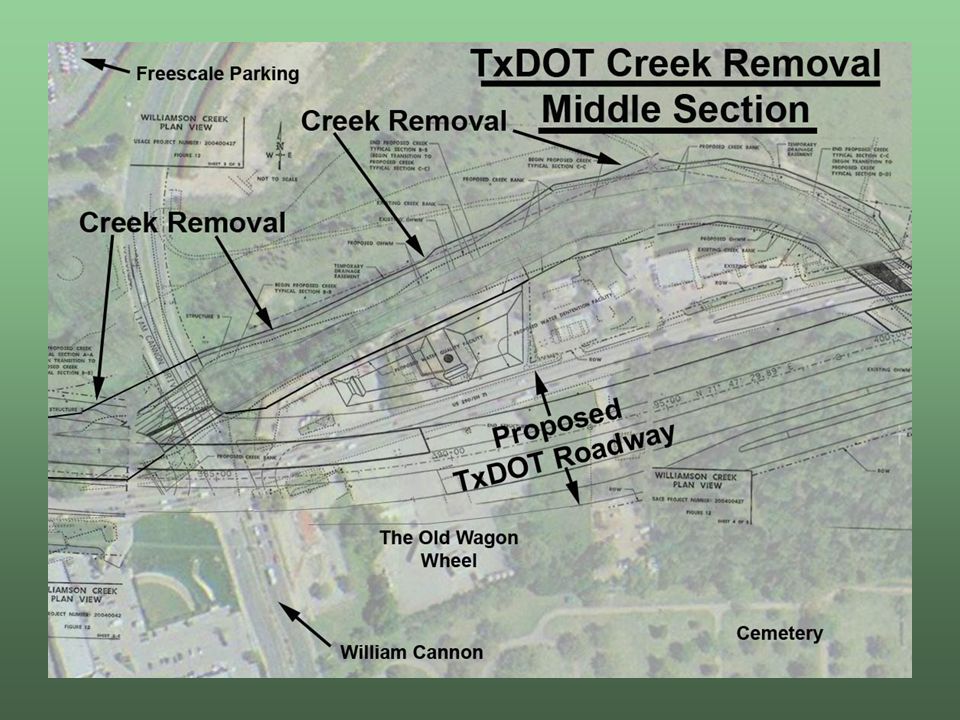
Major Channelization TxDOTs most recent proposal completely eliminated almost 6,000 feet of Williamson Creek From Old Bee Caves Road to the 290 crossing near the old Patton Building TxDOT proposed a 100 foot wide drainage ditch to hold the excess stormwater runoff to prevent flooding downstream This section of creek is perennially spring fed and would be completely removed under TxDOTs plan

25
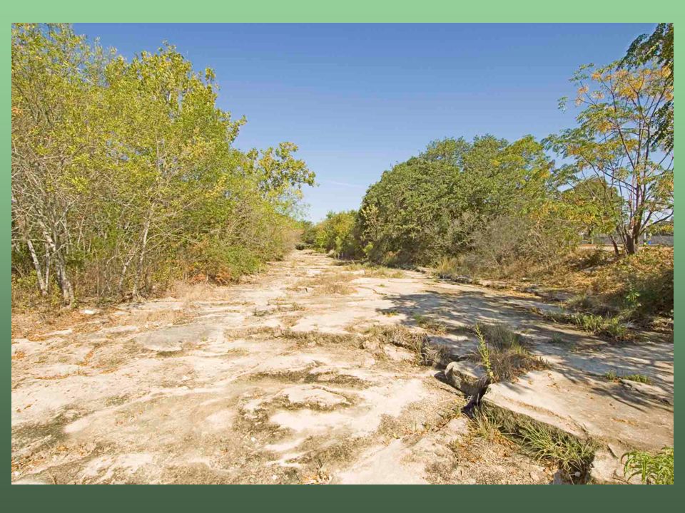
6,000 feet of creek

28
Edwards Aquifer Recharge Zone

29
Artificial Recharge Structure TxDOTs proposal is 90 wide and1800 long totaling almost 4 acres

30
4 acres of Gabion Lined Channel over the Recharge Zone

31
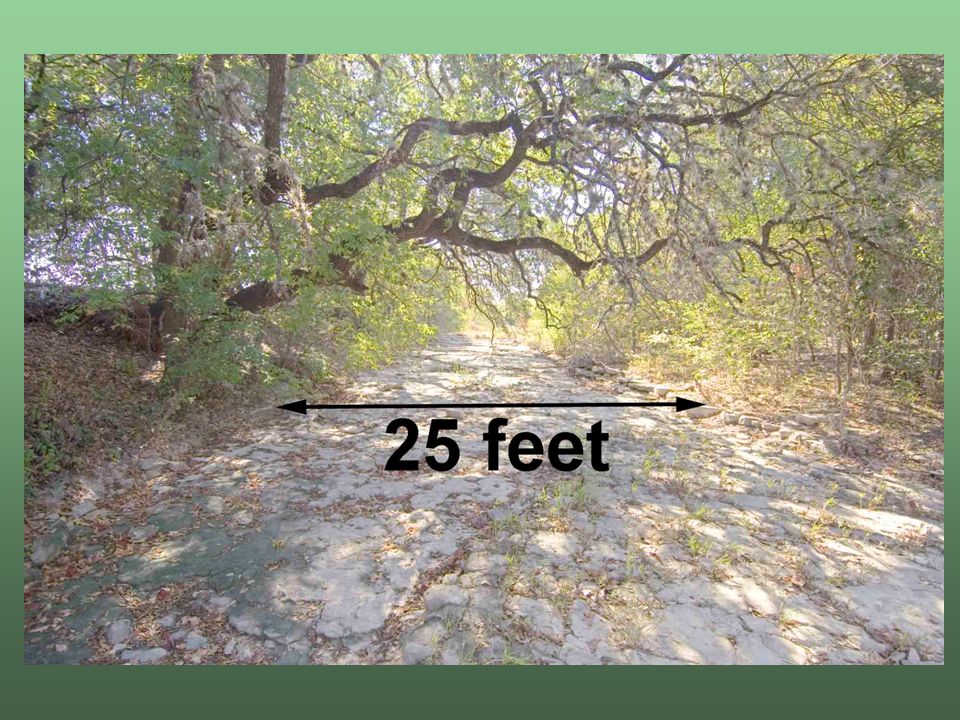
US 290 is about 60 feet wide – TxDOTs channel proposal is 90 feet wide and extends from the 290 crossing to the end of the ball fields

36
Artificial Recharge Structure TxDOTs proposal is 90 wide and1800 long totaling almost 4 acres

37
TxDOT Delays Project TxDOT's January 2005 Nationwide Permit application for construction in waters of the United States was rejected in October 2006 by the Army Corps of Engineers. Reason for the rejection: complete removal and elimination of over a mile of Williamson Creek. The Corps says that TxDOT must apply for an individual Section 404 permit to build the project as proposed, or reduce the scope of the project. An individual 404 permit is a Clean Water Act permit that is almost as cumbersome and time intensive as a new Environmental Impact Statement. A nationwide permit is a general permit allowed for activities such as bridge, dock or breakwater construction. The 404 individual permit implies significantly more delay than a Nationwide Permit. TxDOT failed to inform U.S. Fish and Wildlife Service (USFW) of its plans to modify Williamson Creek in its Biological Assessment of the project, under Section 7 of the Endangered Species Act, submitted in March 2005. The impacts to the endangered Barton Creek Salamander were the focus of the Biological Assessment. This salamander lives in the Edwards Aquifer. The recharge zone of the aquifer extends underneath 1,800 feet of what TxDOT was proposing for creek modifications and stormwater comes from both the recharge zone and its upstream contributing zone. The USFW will not officially comment on this project until new construction plans, which include modifications to the creek, are submitted. TxDOT failed to inform the Texas Commission on Environmental Quality (TCEQ) of the proposed creek modifications in its Water Pollution Abatement Plan (WPAP) application dated March 10, 2005 and approved May 16, 2005. TCEQ confronted TxDOT about the proposed construction within the contributing and recharge zones of the Edwards Aquifer and is now awaiting revisions to the WPAP application to acknowledge a project design change or modifications to Williamson Creek. The Federal Highway Administration Environmental Impact Statement (EIS) rules require that an Environmental Impact Statement (EIS) be reviewed, revised and or supplemented if a project is not built within two years (the EIS was initially approved in 1988). TxDOT started their review of the EIS in the Summer of 2006 and said that they would be completed in the fall of 2006. In October 2006 TxDOT delayed the completion of the EIS Review until September 2007. Upon completion of this review, design modifications will have to take place which will take considerable addition time.
 of its plans to modify Williamson Creek in its Biological Assessment of the project, under Section 7 of the Endangered Species Act, submitted in March The impacts to the endangered Barton Creek Salamander were the focus of the Biological Assessment. This salamander lives in the Edwards Aquifer. The recharge zone of the aquifer extends underneath 1,800 feet of what TxDOT was proposing for creek modifications and stormwater comes from both the recharge zone and its upstream contributing zone. The USFW will not officially comment on this project until new construction plans, which include modifications to the creek, are submitted. TxDOT failed to inform the Texas Commission on Environmental Quality (TCEQ) of the proposed creek modifications in its Water Pollution Abatement Plan (WPAP) application dated March 10, 2005 and approved May 16, TCEQ confronted TxDOT about the proposed construction within the contributing and recharge zones of the Edwards Aquifer and is now awaiting revisions to the WPAP application to acknowledge a project design change or modifications to Williamson Creek. The Federal Highway Administration Environmental Impact Statement (EIS) rules require that an Environmental Impact Statement (EIS) be reviewed, revised and or supplemented if a project is not built within two years (the EIS was initially approved in 1988). TxDOT started their review of the EIS in the Summer of 2006 and said that they would be completed in the fall of In October 2006 TxDOT delayed the completion of the EIS Review until September Upon completion of this review, design modifications will have to take place which will take considerable addition time..")
38
Review The only way that TxDOT can meet environmental permitting laws requires a significant reduction in proposed impervious cover. There is not enough room on the project site to do the pollution control required to accommodate this project. Through incompetence or intentionally, TxDOT has failed to include critical environmental information in permit applications or endangered species assessments to the TCEQ, USFW and Army Corp of Engineers. All three permits have been either denied or are awaiting further information from TxDOT. TxDOT has been redesigning this project since November 2006 and has repeatedly refused to share any information about the redesign with Fix290, The City of Austin, TCEQ, USFW and the Army Corp of Engineers.

39
TxDOTs Alternative TxDOT has only one real alternative based on the TIP at the January CAMPO meeting where 290/71 is a tolled roadway. This is alternative 1B from the 1996 HWY 290 Task Force. TxDOT declared that the entire 1996 Task Force recommendations were not feasible. In addition, Alternative 1B will now require 4 frontage road lanes in each direction because in a tolling situation, the frontage roads have a failing level of service with only 3 lanes. This will total 14 lanes.

41
What This All Means? The parkway alternative is the only viable alternative for TxDOTs project in Oak Hill. It has the limited impervious cover that will allow the environmental regulations of the Texas Commission on Environmental Quality, The US Fish and Wildlife Service and the Army Corp of Engineers to issue their permits.

42
What YOU can do to help Vote your support and call: Kirk Watson, Mike Krusee, Will Wynn, Lloyd Doggett, Bob Daigh, Mike Aulick MOST IMPORTANTLY: Lobby your neighborhood association, the Oak Hill Association of Neighborhoods and the Oak Hill Business and Professional Association

43
Data Source: TxDOT 5 County Annual Average Daily Traffic Counts (Excel – 02/27/07). 2006 counts will be released in the Fall of 2007

Similar presentations


 )Project Community Advisory Committee July 11, 2007 Meeting.>")


 Kelly Dunlap.>")


