Download presentation
Presentation is loading. Please wait.

1
UNITED NATIONS/AFRICAN UNION CIVILIAN POLICE COURSE LAND NAVIGATION BY WARRANT OFFICER ONE FREDRICK MAINA 5 TH JUNE 2013

2
INTRODUCTION Map Reading is a life skill. Improper use of map or lack of knowledge of map reading can result in casualties in a combat area. Working in unfamiliar environments like in UN and AU missions calls upon the participants to have some basic map reading skills. How would the Knowledge got in map reading assist you in your mission?

3
Locate own position Locate positions of other mission colleagues Judge distance Judge speed Tell direction Move from one point to another easily. The following are examples of conditions that you may find yourself in during your mission;

9
OBJECTIVE At the end of the lesson, the participants should be able to set maps, use Grid Reference in giving locations and explain the land navigation procedure correctly.

10
SCOPE Introduction Basic definitions Marginal Information on a map Points of a compass Grid System and Grid Reference Map setting Conclusion Q & A

11
DEFINITIONS Map Is a graphic representation of a piece of ground drawn to scale. Navigation Is defined as a method of maintaining direction both during the day and night. Scale Is defined as the ratio of the distance on a map to the actual distance on the ground.

12
Map Title Map Scale Key to the Map Index to adjoining sheets Marginal Information

13
POINTS OF A COMPASS A compass has four main points, called cardinal points. These are North, South, East and West.

14
The points half way between the cardinal points are called intercardinal points. The intercardinal points are NE, SE, SW and NW

15
There are eight more points on the compass. They lie half way between the cardinal points and the intercardinal. They are called secondary intercardinal points.

17
NORTH POINTS True North – Is the direction of the North Pole from the observer. Grid North – Is the direction in which the perpendicular grid lines point towards the top of the map. Magnetic North – Is the direction in which the needle of a compass points.

18
INSTRUMENTS OF NAVIGATION Instruments of Navigation include; Compasses Global Positioning System Maps

19
GRID SYSTEM Is a network of parallel lines drawn on maps, so that they intersect at right angles. 65 67 68 69 70 66 71 65 67 68 69 70 66 71 404142454344 404142454344 EASTINGS NORTHINGS Four-Figure Grid Reference 4368

20
GRID REFERENCE Is defined as a method of locating a position on a gridded map In locating a feature using the grid reference, Easting is given first followed by the Northing. There are a number of grid references e.g. four-figure, six-figure etc The following figures indicate a four and six-figure grid references respectively.

21
A B C D E 1181 10 1112 1314

22
11 12 12 11 81 82 A B C D E F 1 23456789 1 2345678 9 1 2 8 9 7 6 5 4 3 1 2 8 9 7 6 5 4 3

23
GIVING A GRID REFERENCE REMEMBER TO FIRST MUST GIVE THE EASTINGS FOLLOWED BY THE NORTHINGS 332 613

24
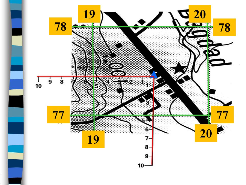
USE OF ROAMERS IN GIVING GRID REFERENCES A roamer scale is a simple device used for accurately measuring the position of a point within a grid square instead of estimating the tenths.

25
78 77 19 20
26
QUIZ WHAT IS THE SIX-FIGURE GRID REFERENCE OF THE AGRICULTURAL DEPARTMENT EXPERIMENTAL STATION?

28
ANSWER 751381

29
QUIZ WHAT IS THE FEATURE FOUND AT GRID REFERENCE 668366 TO THE NORTH-EAST OF KITENKELA SWAMP?

31
ANSWER WATER HOLE

32
COMPASS A compass is a simple precision instrument that is used for finding direction, location and navigation. There are many compasses available in the market but most fall into one of two categories, the 'Prismatic' type and the plain 'Silva' type.

33
MAP SETTING This is placing the map on the ground positionally, so that it can correspond to the area it represents. A COMPASS CAN BE USED TO FIND THE MAGNETIC NORTH WHILE SETTING THE MAP

34
ACTUAL NAVIGATION To be conversant with navigation, one has to have adequate knowledge in; Use of maps Use of compasses/protractors Global Positioning System Taking/measuring/conversion of bearing Measuring/judging distance

35
ACTUAL NAVIGATION CONTINUED Before you leave your current location to the next; Identify the GR of your current position Take the GR of your next destination Estimate the distance between the two Grid References

36
ACTUAL NAVIGATION CONTINUED Appreciate the ground between the two Grid References Then match off to your destination using the compass or the GPS. Repeat the above steps to proceed to subsequent waypoints

37
CONCLUSION If you feel that you are lost during navigation; Don’t panic!! Stop, note the time and confirm if you are really lost. If you are lost, retrace your steps by heading towards a known feature. On arriving at a known feature re-plot your route and start fresh navigation.

38
ANY QUESTIONS

Similar presentations


>")


, east (E), south (S)>")


