Download presentation
Presentation is loading. Please wait.

1
North Saskatchewan River Planning Area Hydrology Bart Oegema, MASc, PEng Senior Hydrologist, SWA November 24-25, 2004

2
Hydrology Outline Climate Runoff Streamflows Lake levels

3
Climate Mean annual precipitation varies from 360 mm/yr at Unity to 470 mm/yr at Waskesiu. Temperatures warmest in southwest, cooler in north and northeast. Average evaporation from lakes varies from 925 mm/yr in southwest to 750 mm/yr in northeast. Climate generally reflected in Ecoregions

5
Climate Precipitation varies year to year, 208 mm to 528 mm at Battlefords. And seasonally, maximum in July, minimum in February. What is “normal”? Now 373 mm at North Battleford. Long term average is 350 mm.

8
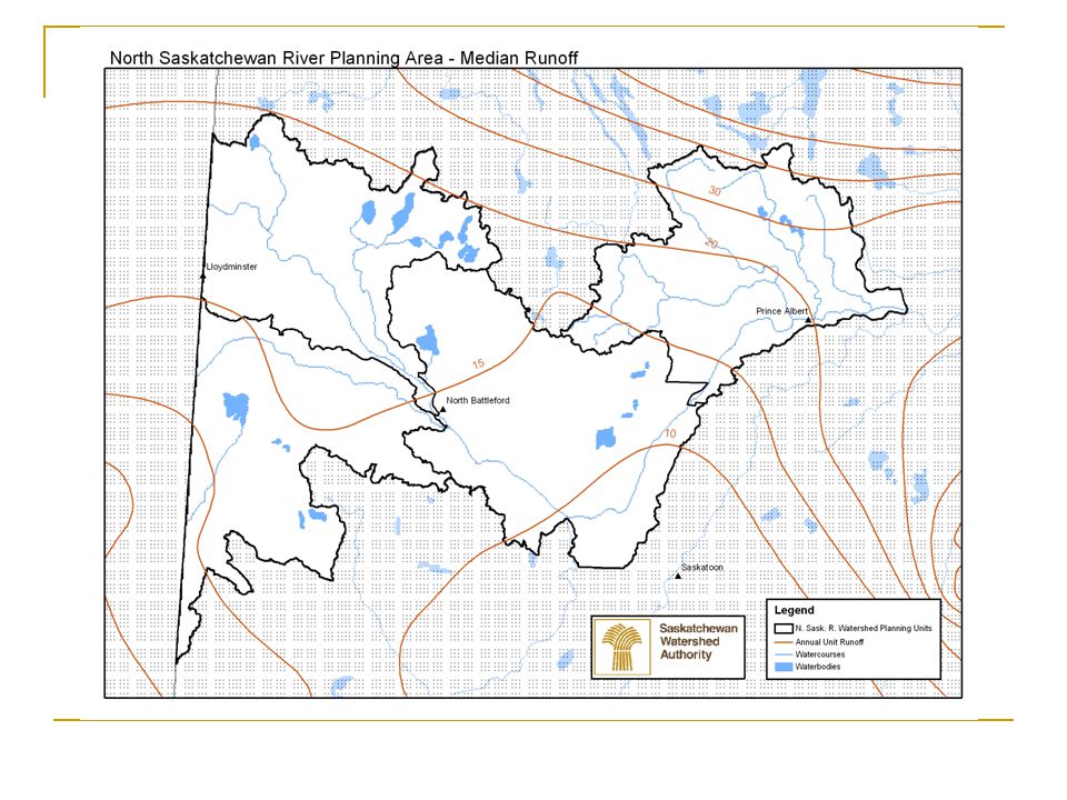
Runoff Runoff = surface water flow from landscape into wetlands, lakes or streams. Only happens when rainfall or snowmelt is in excess of soil infiltration and surface detention capacity, including vegetative canopy storage. Median runoff varies from less than 10 mm to over 250 mm across the province Median runoff varies from less than 10 mm to over 30 mm across planning area.

11
Runoff Prairie hydrology is dominated by precipitation, soil moisture storage, transpiration, wetland storage, and evaporation. Runoff is what is left over, generally less than 10% of annual precipitation.

12
Streamflow Streamflow = that portion of runoff which makes it into a stream network, may include a groundwater contribution. Two types of streamflow in Planning Area; North Saskatchewan River itself – dominated by mountain/foothill hydrology, All other streams – prairie hydrology.

13
North Saskatchewan River Streamflow Peak flows generally in June or July with mountain snowmelt and foothills rainfall. Most (almost 90 %) of the annual flow is generated upstream of Edmonton (212 m 3 /s vs 238 m 3 /s at PA). Two hydro-electric reservoirs upstream of Edmonton; Brazeau, and Bighorn.
 of the annual flow is generated upstream of Edmonton (212 m 3 /s vs 238 m 3 /s at PA). Two hydro-electric reservoirs upstream of Edmonton; Brazeau, and Bighorn..")
15
North Saskatchewan River Streamflow Average annual streamflows vary from 140 m 3 /s to 363 m 3 /s. Range is about 110 % of median average flow. Alberta Environment has detected a downward trend in recorded annual flows at Edmonton. Upstream use was not factored into analysis.

17
North Saskatchewan River Streamflow Annual flow volumes at the Saskatchewan – Alberta boundary are very close to natural.

19
Streamflows – Prairie Hydrology Streamflow peaks usually in April or May due to snowmelt. Declining flows through remainder of the year. Smaller streams may go to zero flow after spring runoff in most years (ephemeral). High variability between years. Battle River is the largest tributary in Saskatchewan.
. High variability between years. Battle River is the largest tributary in Saskatchewan..")
22
Lake Levels Lake levels reflect the dynamic balance between inflow, outflow, and evaporation. Most lakes have an outlet stream. “Terminal” lakes have streams flowing in but no stream flowing out, hence they are the end point or terminal for that stream system.

30
Questions

Similar presentations


>")


>")


