Download presentation
Presentation is loading. Please wait.

1
New Tools for Disseminating Weather and Climate Products and Services Byong-Lyol LEE National Center for AgroMeteorology Seoul National University CALS Republic of Korea International Workshop of CAgM XV, 12~14 July, 2010, Belo Horizonte, Brazil Products/Applications Monitoring Communications User Interface

2
Contents I.Introduction II.Issues & Targets III.WMO Requirements IV.Implementation Plan V.Summary

3
I. Introduction

4
4 Farm management system Resource Management Productivity, stability, quality, sustainability soil, water, biome, infrastructure, human resource, etc. Emergence response system Risk Management Early-warning, advisory, forecast, outlook, prediction, prognosis, projection natural hazards, human-induced risks, etc. Weather : Resources or Hazards ? Up to Us ! Weather : Resources or Hazards ? Up to Us ! AgroMeteorology = [Sun + Wind + Rainfall] +Plants => Products Green Technology => Green Technology using weather resources => Green Growth : 2 nd Green Revolution ?

5
II. Issues & Targets Implementation Targets Global : mitigation - healthy Earth Regional : disasters - early warning National : adaptation - sustainability Rural : emergence response - safety & stability Farming : practices - productivity & economy Global Issues Climate change Economic Crisis WTO/FTA Climate Change Issues Climate Change Issues Uncertainty in prediction Intrinsic Variability Two sides of Coins 2 FEW Resources 2 FEW Resources (too few) F ood, F orest, E nergy W ater
 F ood, F orest, E nergy W ater.")
6
Implementation Stages Short-term : ~ 2 years Emergence responses - Farming level Mid-term : ~10 years Adaptation schemes - National level Long-term : ~30 years Mitigation implementations - Global level Information Requirements Legacy climate data Real time observation NWP-based Forecasts short-, medium-, long-range Climate change projection

7
End-Users/Stakeholders End-Users/Stakeholders Publics Police maker Researcher Extension service Farmer’s cooperation Industries associated Rural residents Farmers Farmer’s Requirements - Accurate information - Site-specific information - Timely information delivery - Easy access to information - Understandable by farmers - Systematic service provision - On-site consulting - Capacity-building

8
Information Tools AWSs Internet/Web TCP/IP WiFi/WiMax Mobile/Smart phone DBMS NWPs AgModels GIS/RS Media - Radio, TV Bulletins Legacy & Novel technologies Information Framework Instrumentation Monitoring Communication Networks Archiving Data Management Processing Analysis/Prognosis Disseminating Communication Interface Feedbacks User-oriented service Service Infrastructure

9
Crucial Bottleneck at levels Global : S & T Enhancement - resource mobilization Regional : Collaboration - trans-boundary activity National : Infrastructure - joint organization Rural : Expertise - capacity building Farming : Accessibility - diverse dissemination Implementation Strategy Global Fund raising, Restructuring Regional RA-specific AgMet program National Resource sharing system Rural Diverse E/T programs Farming Feasible communications

10
1.Improving Service Quality/Delivery ① EC for High Quality resources to meet user requirements ② EC for Risk Management against natural hazards 2.Advancing Science & Technology with Implementing Applications ③ EC for better meteorological information under climate change/variability ④ EC for earth system monitoring relevant to meteorological information 3.Strengthening Capacity-building ⑥ EC to fulfill mandates in emerging members 4.Establishing Closer Collaborations ⑦ Better partnership and cooperation at national & global levels 5.Strengthening Good Governance ⑧ Effective and efficient Organization ⑤ EC for active participation in global S & T development in meteorology III. WMO Requirements http://www.wmo.int/pages/about/spla_en.html ER : Expected Results ST : Strategic Thrusts EC : Enhanced Capabilities

11
Products/Applications Monitoring Communications User Interface ① High Quality resources to meet user requirements 1.Improving Service Quality/Delivery

12
① High Quality resources to meet user requirements 1.Improving Service Quality/Delivery

13
① High Quality resources to meet user requirements 1.Improving Service Quality/Delivery

14
Real Time data & NWP outputs Near real-time operation Rice blast forecast model Web/Mobile-based information delivery ② Risk Management against natural hazards 1.Improving Service Quality/Delivery

16
② Risk Management against natural hazards 1.Improving Service Quality/Delivery http://dmss.ksc.re.kr/dmss.html

17
② Risk Management against natural hazards 1.Improving Service Quality/Delivery

18
③ Better met. information under climate change/variability 2.Advancing S&T with Implementing Applications

19
④ Earth System monitoring relevant to met. information 2.Advancing S&T with Implementing Applications

20
⑤ Active in global S & T development in meteorology 2.Advancing S&T with Implementing Applications

21
⑤ Active in global S & T development in meteorology 2.Advancing S&T with Implementing Applications

22
⑤ Active in global S & T development in meteorology 2.Advancing S&T with Implementing Applications

23
23 uMeteo-K testbed KISTI Cluster KT Cluster KOREN TEIN KISTI Cluster KT Cluster KISTI Cluster ⑤ Active in global S & T development in meteorology 2.Advancing S&T with Implementing Applications

24
⑥ Fulfill mandates in CB for emerging members 3.Strengthening Capacity-building

25
⑥ Fulfill mandates in CB for emerging members 3.Strengthening Capacity-building

26
⑦ Better partnership at national & global levels 4.Establishing Closer Collaborations

27
⑦ Better partnership at national & global levels 4.Establishing Closer Collaborations Collaboration with Universities To Strengthen Expertise and to bring up Scientist to meet future requirements Integration of research groups on CC Science Expanding existing projects Links to GAIA Project & APCC Outcomes expected Research Hub for CC Science Expanding Brain Pool Leading roles in CC Science Outreach and Strategy program International Hub for Earth System

28
Launch of National Center for AgroMeteorolgy as a framework Four institutions (KMA, RDA, KFS, SNU) made MoU for collaborations in AgMet ⑧ Effective and efficient Organization 5.Strengthening Good Governance
 made MoU for collaborations in AgMet ⑧ Effective and efficient Organization 5.Strengthening Good Governance")
29
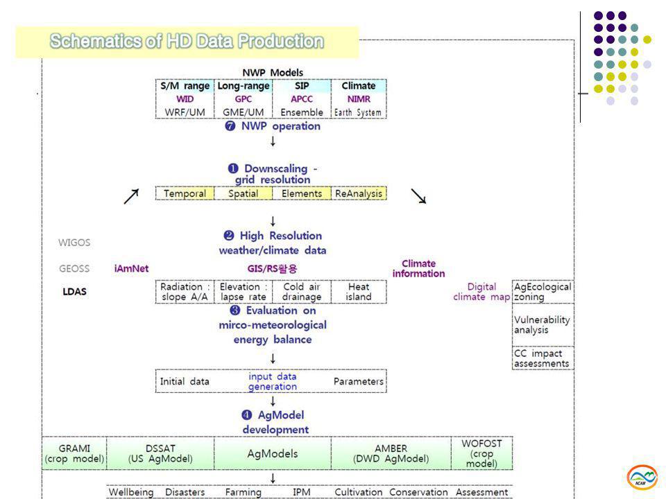
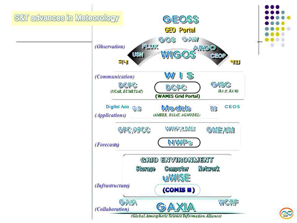
Submission of WIS-DCPC dedicated to WAMIS/CAgM Collaborations with associated institutions in implementations Restoration of WAMIS mirror server at KMA with advanced network (Giga bit) Development of prototype user interface for Grid Portal Case study on linkage between NWP output and Applications Downscaling of NWP output to meet requirements from AgModels Securing ICT resources to support WAMIS Grid Portal for resource sharing Agreement on ICT resource support by KISTI for CAgM KREONET (Giga LAN) was linked without any charge to NCAM Linux Clusters and other computer resources will be arranged when needed High volume of information storage will be provided with DBMS Plan to make MoU among CAgM/KISTI/NCAM IV. Implementation Plan

30
30 Mobilizing Agricultural tools available for CAgM activities DWD & KMA have a bilateral agreement on AMBER Prof. Hoogenbum agreed on joint development of DSSAT as an open source NARC/Japan is willing to provide JAVA based AgModels Joint IT training program in AgroMeteorology for capacity building KOICA is going to support for the expanded AgMet ICT training course RTC-Nanjing made MoU on future joint training programs in AgMet Seoul National University will provide training experts and facilities relevant KMA is going to offer hosting of international training center for ICT training MoU for Joint projects in AgroMeteorology with CAgM NCAM/SNU & ESTC/Goerge-Mason made MoU on collaborations in AgMet IV. Implementation Plan

31
Web Portal information sharing XML-based service : standard schema development Machine translation : multi-lingual interfaces Operational applications based on Web service architecture Tutorial interfaces for real practices GRID Portal Resource sharing Forecast-based AgMet Services for researcher / extension Benchmarking on AMBER (DWD), expanding with DSAT NCAR (GDAS, MM5), DWD (GME, LM) as NWPs Super ensemble of Seasonal Forecasts (APCC / KMA, etc.) GISC / DCPC dedicated to WAMIS will be established (NCAR, DWD) LIS (NASA) as a framework for LSM (GDS / LAS + GRID) IV. Implementation Plan

32
Thank You! Pre-WS of CAgM XV, 12~14 July, Belo Horizonte, Brazil

33
V. Summary Advanced ICTs such as information networks, databases, simulation models, tools for GIS, RS for agrometeorology are an imperative in strengthening national agrometeorological services, particularly in light of climate change and variability. Sharing of resources including IT and human resources available among countries is a promising solution to impending food and water security problems that confront member countries, where limited IT resources present the most critical barrier in improving operational AgroMeteorology services. In addition, the increasing importance of agrometeorological data, such as surface vegetation and soil moisture status from agronomy sectors, is receiving more public recognition than ever before. There is a growing interest in understanding the predictability of weather and climate forecasts using NWP models because it feeds back into the weather and climate systems through atmosphere-biosphere interactions. Agrometeorological information sharing among member countries thus emerges as one of the most vital and dynamic ingredients for strengthening national weather services not only for sustainable Agriculture, but also for enhanced accuracy of weather/climate forecasts in the future.

34
The provision of both data/information and computer resources for models, tools, and products for operational services, specialized or dedicated resource frameworks has great potential for facilitating resource sharing among CAgM member countries, which should then be able to make better use of remotely located resources for agrometeorological services at the national/regional level, especially when providing interactive forecast-based agrometeorological services simply using the Internet or mobile phones. Given an advanced resource sharing environment together with legacy technology for high-performance computing, large-scale diverse data and analysis servers, it will be very useful to have an IT framework for end-users that allows for interactive remote operation of their service development and deployment based on NWP forecasts. Specific interfaces will enable interactive operation for region-specific applications that require and provide The ideal system would consist of 1) servers for simulation models, databases, and system analysis, 2) a high-speed network frame, 3) web service interfaces for simulation models with near-real-time DB access, 4) multi-tiered interface architecture in a distributed computing environment, 5) wireless communications including mobile phones and the media. V. Summary
 servers for simulation models, databases, and system analysis, 2) a high-speed network frame, 3) web service interfaces for simulation models with near-real-time DB access, 4) multi-tiered interface architecture in a distributed computing environment, 5) wireless communications including mobile phones and the media. V. Summary.")
35
The system should be capable of handling diverse data sources, formats, contents from synoptic data, forecasts(S,M,L), prognosis, adaptation data, simulation models for crops, resource management, and farm management among others. It must also accommodate derived products such as detailed climate change scenarios and regional food demand/production predictions. It has been noted that WAMIS needs highly elaborated data handling and distribution mechanisms, including metadata, because it comprises a wide variety of contents in different formats depending on the provider or data manipulation process. While WIS evolves to provide a single entry point for any data request, CAgM is trying to extend its service to member countries under the WIS umbrella by implementing WAMIS into a Grid portal to facilitate the sharing of computer resources for the improvement of members’ operational agrometeorology services. Since operational agrometeorology requires diverse data and information from different disciplines for better services, future information systems for agrometeorology should consider accommodating diverse communications technologies for information and resource dissemination as well. V. Summary

36
KMA has been providing active support for East African member countries through its cooperation with WMO and KOICA. A variety of projects are currently under way. These WMO-KOICA joint programs have been of invaluable help in facilitating KMA's own assistance projects for developing Members. Information and Communication Technologies for Meteorological Service (since 2006) Advanced Analysis of COMS (Communication, Ocean, and Meteorological Satellite) Data (since 2007) Improvement of Meteorological Disaster Responsiveness for African Countries (since 2009) Contribution from Korea
 Advanced Analysis of COMS (Communication, Ocean, and Meteorological Satellite) Data (since 2007) Improvement of Meteorological Disaster Responsiveness for African Countries (since 2009) Contribution from Korea.")
37
KMA-KOICA-WMO joint project on meteorological support for climate change adaptation and public health in East Africa (July 2009) Development of a climate early warning system for 10 East African countries (2009-2010; USD 400,000) Meteorological support for public health to prevent climate change associated spread of diseases such as malaria in Ethiopia and adjoining countries (2009-2010; USD 200,000) Signing of MOU between the Korea Meteorological Administration (KMA) and the Intergovernmental Authority on Development's Climate Prediction and Applications Centre (ICPAC) and the National Meteorological and Hydrological Services (NMHSs) of the 10 ICPAC member countries (April 2010). Contribution from Korea

39
RAII - WIGOS/WIS Standardization In-situ WIGOS WMO Integrated GOS GEONETCast Global Earth Observation System of Systems WIS National level Weather Observation Network : e.g. WWW/GOS, AMDAR, ASAP Atmospheric composition observing network : e.g. GAW etc. Radiation observing networks : e.g. BSRN Marine meteorological networks and arrays : e.g. VOS, ARGO, etc. Hydrological observing networks : e.g. components of WHYCOS Climate components of atmos-, oceano-, terres- observing systems : Flux Integration Remote sensing Regional level

41
(V) GISC SIMDAT GISC UNIDAT Data Broker GDS LAS GTS/WIS APCC GEOSS DataArchitectureNetwork OBSProcess Earth System User Interface DCPC NCARNCDCTIGGE WAMIS Climate Projection SIP GDAPS / GME RDAPS / GME : WRF Mesoscale model Nowcasting Historical (Legacy) data Non-Meteorological Data Surface Flux Vegetation Soil Profile GRID Computing Data Access Computation Research KMA/KISTI WAMIS Grid Portal AMBERDSSAT GIS RS User Interface GridSphere END- USERS K*GRIDeScience LDAS/LIS Flux, GHG FeedBackDecision-Making Impact Assessment Data Grid MME AppliedMeteorology Pilot Projects SIMDATWAMISUNIDAT.... WIS- WAMIS WAMIS Grid Portal ES 2 Earth System eScience Korea WIGOS WMO Integrated GOS WMO Information System

Similar presentations


 Expected Result: 11 EFFECTIVE AND EFFICIENT MANAGEMENT PERFORMANCE AND OVERSIGHT OF THE ORGANIZATION Strategic Plan for the Enhancement.>")


 RA I Sub-Regional Workshops for WIGOS and WIS for West / North Africa Nov 2013 Dr I. Zahumensky, WIGOS-PO.>")


