Download presentation
Presentation is loading. Please wait.

1
General view of Kentisbeare Village

2
The Village Pub

3
St Mary’s

4
The parish Church of St. Mary, Kentisbeare, Devon dates from December 9, 1259 and replaces an earlier Saxon Church. In the churchyard is a yew tree believed to be over 1,000 years old and therefore pre-dating the present church. It is quite likely that our Domesday ancestors stood by this tree and the Saxon church. Yew trees are poisonous to animals and were planted in churchyards primarily to discourage owners from allowing their larger livestock to graze there. The church has many impressive features but of most importance to the Butsons is the Anstice Gallery, named after its benefactor Mrs Anstice Wescombe who provided for it’s construction in 1632. On the front of the gallery is the following poem: Anstice late wife of Robert Wescombe here Built this loft in the church of Kentisbeer For the convenient hearing of the word And praising of the true and living lord She also gave proffit of the same Unto the poor in memory of her name The donors are deceased and all we Who now survive them their good acts do see Wich if they should be quickly out of mind Discourage ‘twill the piously inclined The reason why these lines are set to view It is because the poor shall have their due

5
Anstice Gallery Tablets

6
A Table containing y e Names of such Persons who have been Benefactors, to y e poor of y e Parish of Kentisbeer as followeth. Robert Wescombe gave one Hundred Pounds to be laid out in Land; and for y e better improvement thereof Anstice his wife did freely contribute fourteen Pound and with y e same did purchase Six Pounds p ann for ever to be paid out of two fields called Berry Parks being part of Pool Farm to be distributed by y e approbation of y e church wardens for y e time being, & y e heir of Bradfield for ever Anstice Wescombe did also Erect y e Loft in y e Parish Church of Kentisbeer and gave y e Profit of y e same to y e Poor of y e said Parish for ever. Edmond Cross gave one Hundred Pounds y e interest thereof to remain to y e use of y e Poor of this Parish for ever to be distributed yearly by y e approbation of y e Executor and Trustees of his last will and testament or five of y e most sufficient inhabitants of y e said Parish to such Poor as have no Monthly pay. John Sanders of this Parish gave Three Pounds to be paid every year to y e Poor to be distributed Yearly upon Christmas day y e money to be paid out of and Estate called Sheppards Valey lying in y e Parish of Dunkeswell. A Table containing y e Names of such persons who have been benefactors to y e Poor of y e Parish of Kentisbeer as followeth; Anstice Wescombe gave y e Sum of Thirty Pounds y e Interest thereof to remain to y e use of y e poor of y e Said Parish forever Osmond Butson gave y e Sum of Ten Pounds Oliver Butson his Son gave Ten Pounds John Berry gave Ten Pounds John ? gave Ten Pounds William Walrond gave six Pounds fifteen Shillings Ann Hake gave forty Shillings One Willy of Willand gave 6 Pound John Bale gave Twenty Pounds Agnes Heffield gave Fifty Pounds Thomas Butson gave Forty Pounds Henry Butson gave Ten Pounds William Eveleigh gave Ten Pounds William Eveleigh Jun r gave 4 Pounds Robert Merson gave Five Pounds John Westlake gave Ten Pounds There is Six Pounds and Ten Shillings more given for y e use of y e Poor by whom y e same was given cannot be remembered The Sum Total given is £454-3s-4d y e Interest thereof is to be distributed by y e Church Wardens and Overseers for y e Poor of y e said Parish to such Poor as have no Monthly pay Three Pounds of y e said Interest is to be given in Bread yearly

7
I believe that the Thomas Butson named as donating £40 was the Thomas christened at Uffculme on Jan 9, 1584. son of Henry c. Dec, 1549 – Uffculme and Emote Whyet, (married Jun 13, 1580 – Uffculme). The donation following his, from Henry, may be his father son or brother. Thomas was a man of substance in his community, aged 48 in 1632. Possibly the same Thomas who signed the protestation to King Charles at St. Merryn in Cornwall 10 years later in 1642. Uffculme is some 3 miles to the north of Kentisbeare and for anyone who was in the farming community between Kentisbeare and Uffculme, would be a reasonable choice for baptism. The Thomas Butson who lived at St Merryn was also a leading member of the community During the English Civil War (1642-1651) Kentisbeare was for Cromwell and Parliament and St Merryn was for King Charles
. The donation following his, from Henry, may be his father son or brother. Thomas was a man of substance in his community, aged 48 in Possibly the same Thomas who signed the protestation to King Charles at St. Merryn in Cornwall 10 years later in Uffculme is some 3 miles to the north of Kentisbeare and for anyone who was in the farming community between Kentisbeare and Uffculme, would be a reasonable choice for baptism. The Thomas Butson who lived at St Merryn was also a leading member of the community During the English Civil War ( ) Kentisbeare was for Cromwell and Parliament and St Merryn was for King Charles.")
8
Butson’s Farm

9
Butson’s Farm is far more ancient than it appears from this photograph Helen Barrett in her book “Our Heritage” says Butson’s Farm otherwise Botuston(c.1200), Botyston juxta Kentelesbere (1339), Butson (1610). It was held c. 1200 by Radulf Boty who is mentioned under Blackborough 1624 Agnes, Edward, George, Henerie, James and Margerie Butson paid subsidies on land in Kentesbeare 1797 James Hellings paid rates for Butson’s Farm. In 1841 the owner was mentioned in the Tithe Apportionments as the Earl of Egremont,and Henry Cook, tenant When The Wyndham Estate was sold in 1915 part of Butson’s was bought by Samuel Morish and part by C Derham

11
Today, the farmyard, stables and other outbuildings have been turned into houses and the whole entity is known as Butson’s Court We found references to the Butson name and also to the Brooke name (a medieval Butson Alias). The inscribed tap is connected to the water course that runs through the back of the farm On the following map, Butson’s Farm can be seen close to the village centre

12
Butson’s Farm St Mary’s Church

13
The water courses feeding the Butson farm and others around the village are very ancient. A deed dated 1339 confirms that as well as serving Kentesbeare, the water has been channelled all the way to Cullompton some 3 miles distant having already travelled some 2 ½ miles from its spring source just below Blackborough A mill existed at Goodiford and is mentioned in Domesday. Mills need water and as no rivers flow through the area, artificial courses in the form of leats would have had to have been created The reference to the River Ken is a fairly recent invention which belies the effort put in by our ancestors to undertake such a large project. The next picture show part of the water course at Stoford where as well as modern culvert pipes we can see some old stonework creating banks The lack of water flow is due to an unseasonal lack of rainfall in the month preceding the taking of this photo

16
Blackborough is where Radulf Buty lived and I believe he is descended from the Domesday land holder Ralf Botin (also referred to as Botu) Before the Norman Conquest of Britain, people did not have hereditary surnames: they were known just by a personal name or nickname. Many individuals and families have changed their names or adopted an alias at some time in the past When communities were small each person was identifiable by a single name, but as the population increased, it gradually became necessary to identify people further - leading to names such as John the butcher, William the short, Henry from Sutton, Mary of the wood, Roger son of Richard. Over time many names became corrupted and their original meaning is now not easily seen. After 1066, the Norman barons introduced surnames into England, and the practice gradually spread. Initially, the identifying names were changed or dropped at will, but eventually they began to stick and to get passed on. So trades, nicknames, places of origin, and fathers' names became fixed surnames There has also been an unfortunate habit amongst the English to corrupt, shorten and use diminutive forms of a name The connection between Botin(or Botu) and Boty (or Buty) is that in 1086 Botin (or Botu) holds Blackberge and in 1200 Boty (or Buty) held Blackborough Boty (and Ponchy Down). These are one and the same place so I conclude that the names are also one and the same
 and Boty (or Buty) is that in 1086 Botin (or Botu) holds Blackberge and in 1200 Boty (or Buty) held Blackborough Boty (and Ponchy Down). These are one and the same place so I conclude that the names are also one and the same.")
17
This photograph was taken on the northern side of Blackborough Common and shows an early (possibly Iron Age) fortification of ditch and bank which continues for a few hundred yards around the base of the hill. Most of the area is now heavily forested with Scots Pines and managed by the Forestry Commission The earth is noticeably dark almost black and fits well with the description “The black hill owned by Boty” which is the translation of the early name (Blakesbeares Boty) for Blackborough
 for Blackborough.")
19
An aerial view of Blackborough Common looking South The flat top to Blackborough Common would have been ideal for grazing animals and setting up an enclosure with houses. The Western bank is naturally steep and the Northern bank is where we found the ditch and bank fortifications S N W E To Kentisbeare (2 miles)
.")
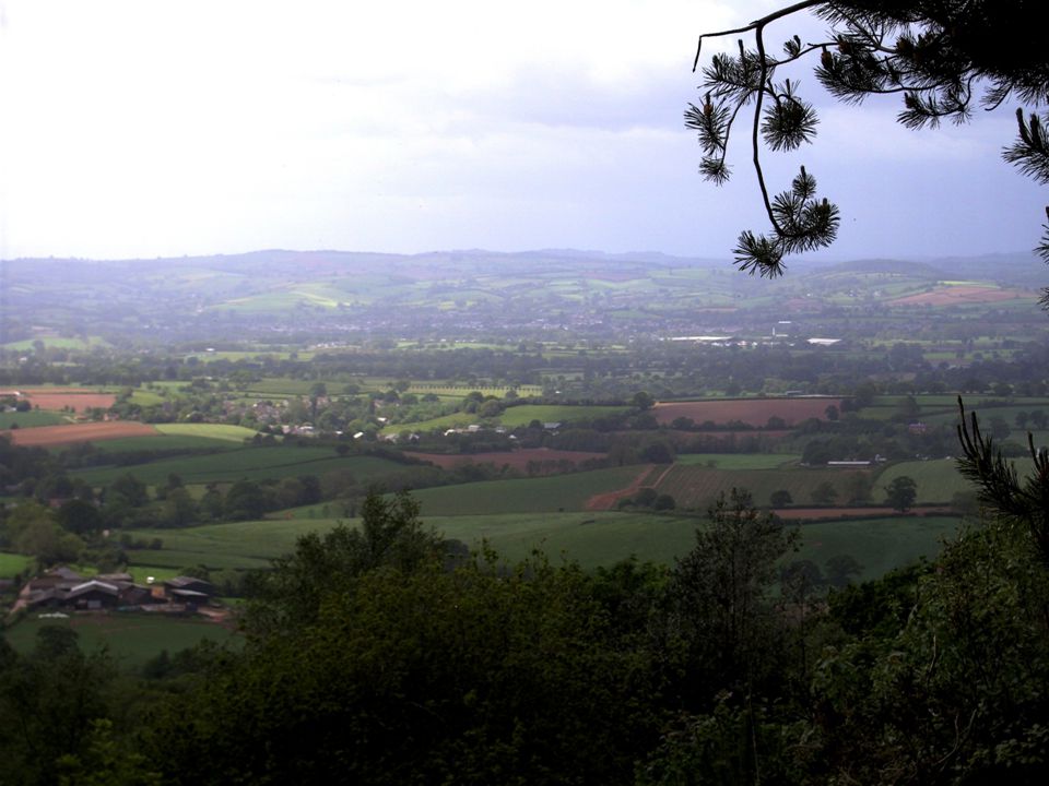
20
The view from the top of Blackborough Common which is just short of 300 Metres above sea level. The top is heavily forested today and some 20 Metres lower than it would have been in Ralf Botins time due to extensive mining for whetstone. Much of this took place in the 18 th and 19 th centuries and caused the collapse of the hilltop. The area which is flat at the top of Blackborough Common would be around 100 Acres (700 Yards by 700 Yards) which ties in with the Domesday records of Ralf’s holdings. Also the present day name Common suggests that at some time this could have been grazing land Ponchydown is just below and adjacent to Blackborough Common Everything we have seen and described seems to add weight to the theory that Ralf Botin is the first Butson and that the name descended through to Radulf Buty who owned Buty’s Tun (an enclosed area of land). Buty's Tun changed into Butson and still exists today through Butson’s Farm in Kentesbeare We will never know for certain but please cousins have faith John Butson
 which ties in with the Domesday records of Ralf’s holdings. Also the present day name Common suggests that at some time this could have been grazing land Ponchydown is just below and adjacent to Blackborough Common Everything we have seen and described seems to add weight to the theory that Ralf Botin is the first Butson and that the name descended through to Radulf Buty who owned Buty’s Tun (an enclosed area of land). Buty s Tun changed into Butson and still exists today through Butson’s Farm in Kentesbeare We will never know for certain but please cousins have faith John Butson.")
Similar presentations


.>")


