Download presentation
Presentation is loading. Please wait.

1
Airborne Doppler lidar surface returns: data products other than tropospheric winds
G. D. Emmitt and C. O’Handley Simpson Weather Associates Charlottesville, VA. Hangzhou, China October, 2002

2
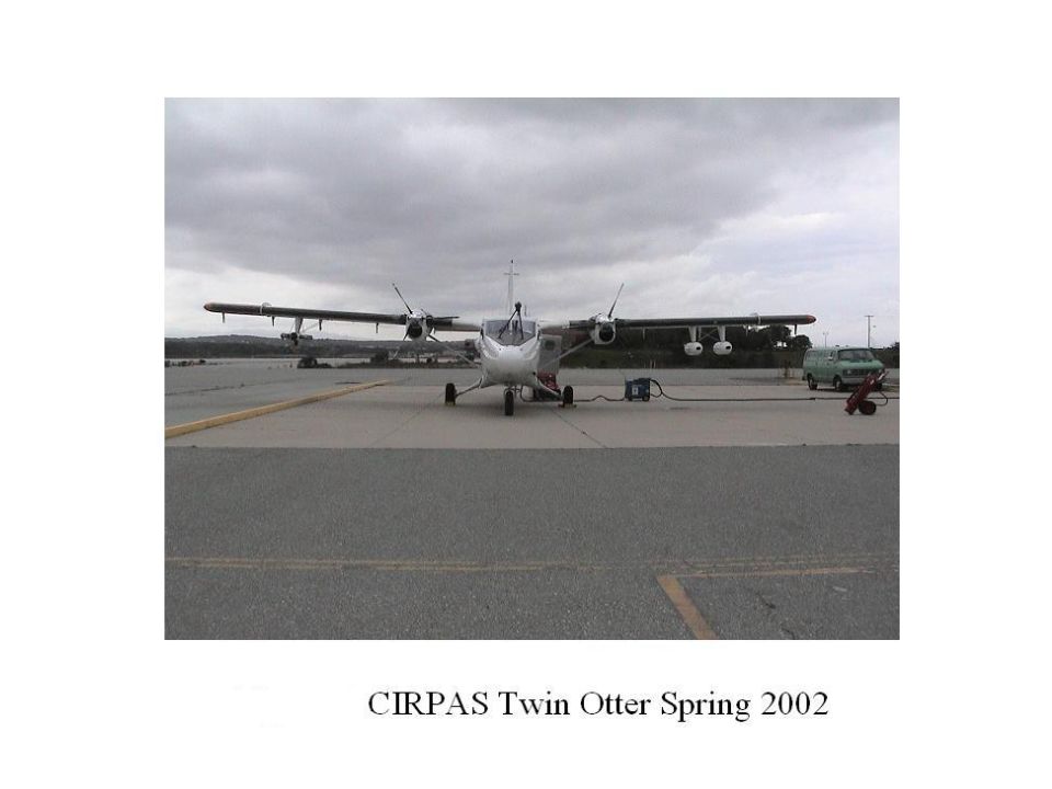
TODWL: the program (Twin Otter Doppler Wind Lidar)
SPAWAR and ONR 35/SBIR Program provided the lidar and supported its integration into the CIRPAS Twin Otter IPO has co-funded the lidar adaptation to the Twin Otter. IPO has solely funded the mission planning, flight hours, data collection and the post flight installation of the lidar in a trailer for inter-flight research.

3
TODWL : the aircraft Navy Twin Otter operated by CIRPAS out of Marina, CA Unpressurized (~ 10 ft normal operations) Cruise speeds kts Equiped with: GPS/INS Dropsonde aerosol probes temperature, water vapor, turbulence sensors

5
TODWL : the instrument 2µm coherent detection 4-6 mJ (330 nsec pulse)
80 Hz water cooled ~7-10% total system efficiency 10 cm two axis scanner, side door mounted GUI with realtime instrument control and data display Weight: 250lb Power: 1.5 KW

6
TODWL 2-axis scanner

7
The Experiments Airborne missions over various water bodies (open ocean, surf zone, large rivers, lakes and wetlands) in the vicinity of Monterey, CA Laboratory studies using a water slide to simulate observations at differing incidence angles

8
Objectives Check out the operations of an airborne 2µm coherent, semi-hemispherical scanned DWL Investigate the utility of water surface returns at 2µm for space-based and airborne DWLs (ocean, lake, river, & wetlands) Compare DWL wind soundings with RAOBs, microwave sounders, met towers, ground-based DWLs and assorted surface observations Investigate the use of an airborne DWL to provide cal/val data for scatterometers and RadarSat Demonstrate the application of LAHDSSA for future space-based DWL missions. Collect aerosol data along with lidar data to assist in the interpretation of signals from the LAS
 Compare DWL wind soundings with RAOBs, microwave sounders, met towers, ground-based DWLs and assorted surface observations. Investigate the use of an airborne DWL to provide cal/val data for scatterometers and RadarSat. Demonstrate the application of LAHDSSA for future space-based DWL missions. Collect aerosol data along with lidar data to assist in the interpretation of signals from the LAS.")
9
0030 UTC March 2002 TODWL sounding looking up (20seconds)
Aircraft flight level Microwave sounding Ft Ord (30 minutes) TODWL sounding looking down (20 seconds)
 TODWL sounding. looking down (20 seconds)")
10
Water surface returns as a function of incidence angle at 2µm with a coherent Doppler lidar

11
Modeled reflectance from ocean surface
along wind direction Cross wind direction Modeled reflectance from ocean surface for a wind speed of 7.5m/s (Tratt, 2002)
")
12
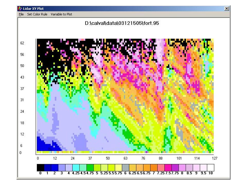
TODWL returns collected over Monterey Bay, 12 March 2002
1600 Water surface returns 1400 LAS returns 1200 Range from aircraft (meters) 1000 800 600 400 200 Nadir angle Relative spectral amplitude (range corrected) using 400 shot integration
 Nadir angle. Relative spectral amplitude (range corrected) using 400 shot integration.")
13
Single shot data used to obtain 400 shot average
Water surface Single shot data used to obtain 400 shot average at ~3 degrees off nadir

14
Single shot data used to obtain 400 shot average
Water surface Single shot data used to obtain 400 shot average at ~33 degrees off nadir

15
TODWL signal as a function of nadir angle

16
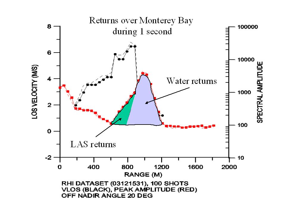
LAS Water Spectrum for range gate 20 associated with the data shown in previous slide. The data has not been fully corrected for the aircraft forward motion

17
Observing ocean wave motion and the atmospheric
Layer Adjacent to the Surface (LAS)
")
18
Monterey Bay 12 March 2002

22
Organized Large Eddies within the Marine Atmospheric Boundary Layer
Investigation of Organized Large Eddies within the Marine Atmospheric Boundary Layer

28
Summary In addition to horizontal and vertical winds, an airborne
Doppler lidar can be used to study water surface motions and their correlations with aerosols. These correlations have significance in the interpretation of data obtained with space based lidars and also the parameterization of fluxes over water surfaces at wind speeds above those that produce whitecaps. The investigation of Organized Large Eddies will be among the objectives of future TODWL flights

29
Acknowledgements This work was funded by the Office of Naval Research through the Center for Interdisciplinary Remotely-piloted Aircraft Studies and by the Integrated Program Office of NPOESS

30
TODWL Twin Otter Doppler Wind Lidar First Flight Series
Navy Twin Otter Operated by CIRPAS Equipped for aerosol sampling First Flight Series 11-15 Feb. 2002 PIs: Emmitt and Bluth 2 m lidar 10 cm scanner (1st of its kind) Signals 5 km ahead of aircraft for backscatter calibration using particle probes VADS to measure LOS component of aircraft TAS Funded by USN and IPO
 Signals 5 km ahead. of aircraft for backscatter. calibration using particle. probes. VADS to measure. LOS component of. aircraft TAS. Funded by USN and IPO.")
31
CTI TODWL obtaining a wind profile above the aircraft

32
Particle Probe Cluster

33
Cloud Streets over Monterey Bay, February, 2002

34
TODWL: participants Simpson Weather Associates (SWA) G. D. Emmitt Science lead C. O’Handley Data processing and advanced algorithm development S. Greco Ancillary data from sounders, buoys, numerical models and other data sources for comparison
 G. D. Emmitt Science lead C. O’Handley Data processing and advanced algorithm development S. Greco Ancillary data from sounders, buoys, numerical models and other data sources for comparison.")
35
Center for Interdisciplinary Remotely Piloted Aircraft Studies (CIRPAS)
R. Bluth Platform lead Nava Roy Software support Haf Jonsson Aerosol probe data responsibility Mike Duncan Project oversight Roy Woods Pilot and aircraft systems engineer Mike Hubbell Chief pilot

36
Coherent Technologies Incorporated (CTI) Steve Shertz (steves@ctilidar
Coherent Technologies Incorporated (CTI) Steve Shertz TODWL would not have happened without his technical support Phil Gatt Project responsibility within CTI. Also provided experience based input to the operations of the TODWL lidar Rod Munson Software support University of Alabama at Huntsville (UAH) David Bowdle Aerosol/Lidar backscatter
 Steve Shertz TODWL would not have happened without his technical support Phil Gatt Project responsibility within CTI. Also provided experience based input to the operations of the TODWL lidar Rod Munson Software support. University of Alabama at Huntsville (UAH) David Bowdle Aerosol/Lidar backscatter.")
37
University of Washington (UW) Ralph Foster (ralph@apl. washington
University of Washington (UW) Ralph Foster Arranged for RADARSAT data collection over the Monterey Bay during TODWL flights Robert Brown Involved in the interpretation of QuikScat and RADARSAT data taken during TODWL under-flights United States Geological Survey (USGS) John Costa Arranged for surface flow velocity observations on the San Joaquin River during TODWL overflights. NOAA Environmental Technology Laboratory (ETL) M. Hardesty Helped arrange for lidar operations during TODWL over flights A. Brewer Operated NOAA’s lidars during the overflights
 Ralph Foster Arranged for RADARSAT data collection over the Monterey Bay during TODWL flights. Robert Brown Involved in the interpretation of QuikScat and RADARSAT data taken during TODWL under-flights United States Geological Survey (USGS) John Costa Arranged for surface flow velocity observations on the San Joaquin River during TODWL overflights. NOAA Environmental Technology Laboratory (ETL) M. Hardesty Helped arrange for lidar operations during TODWL over flights A. Brewer Operated NOAA’s lidars during the overflights.")
Similar presentations


>")
 Products and Measurements Presented by Patrick Selmer Goddard advisor: Dr. Matthew McGill Assisted.>")


 Ship Field Duration – 30 days Time Window.>")


 Wind Profiling from the Howard University Beltsville Research.>")


