Download presentation
Presentation is loading. Please wait.

1
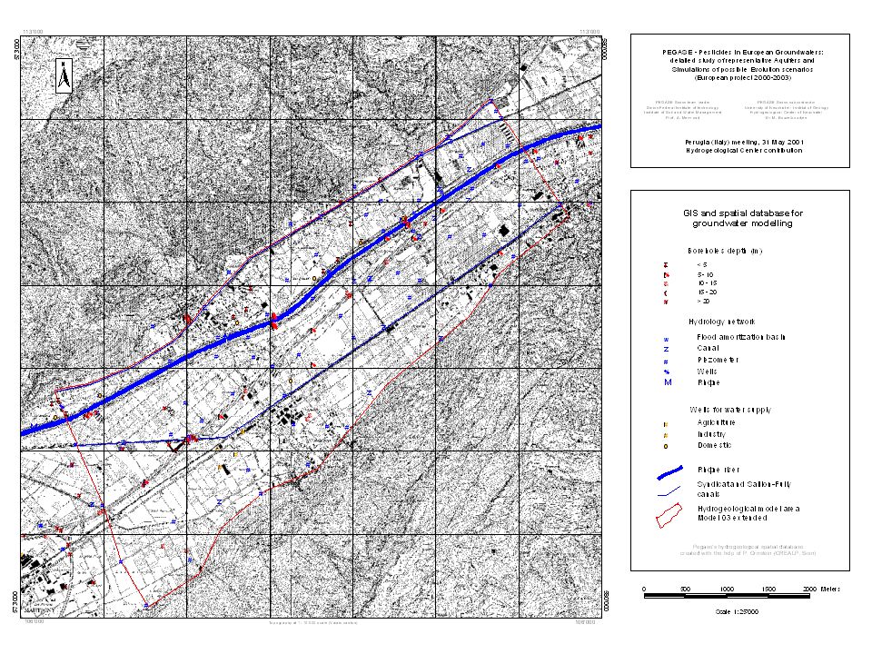
PEGASES meeting, DTU Lingby 24-26 March 2003 PEGASE – Pesticides in European Groundwaters : detailled study of representative Aquifers and Simulations of possible Evolution scenarios (European project 2000-2003) Martigny Site (Switzerland) : Hydrogeological Contribution Mahmoud Bouzelboudjen, Eric Di Gioia University of Neuchâtel, Switzerland In collaboration with Kirsten Meiwirth & Marc Soutter Swiss Federal Institute of Technology and Pascal Ornstein & Jean-Daniel Rouiller Centre de Recherche Alpin, Sion, Switzerland Prof. André Mermoud, PEGASE Swiss Team Leader, Swiss Federal Institute of Technology, Lausanne

2
CONTENTS Situation and data Water table behavior 3D Groundwater modelling with Marthe Dataset provided

3
PEGASE Project (Martigny, Switzerland)
")
5
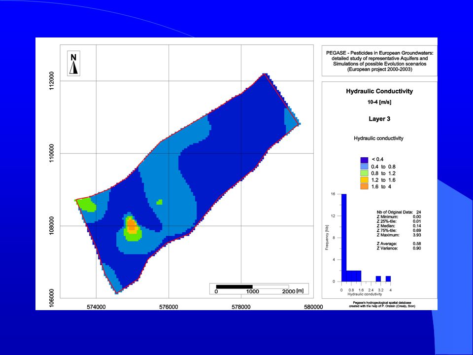
3D Groundwater Model : Thickness [m]Permeability 10 -4 [m/s] Upper Silt (86 boreholes) Upper Silt (86 boreholes) 3.50.5 Upper Gravel (35 boreholes) Upper Gravel (35 boreholes) 8.56.5 Middle Silt (24 boreholes) Middle Silt (24 boreholes) 6.00.6 Lower Gravel (24 boreholes) Lower Gravel (24 boreholes) 8.0 (cst)7.0 Thickness (M) of Upper Silt (Layer 1) and Upper gravel (Layer 2)
![3D Groundwater Model : Thickness [m]Permeability [m/s] Upper Silt (86 boreholes) Upper Silt (86 boreholes) Upper Gravel (35 boreholes) Upper Gravel (35 boreholes) Middle Silt (24 boreholes) Middle Silt (24 boreholes) Lower Gravel (24 boreholes) Lower Gravel (24 boreholes) 8.0 (cst)7.0 Thickness (M) of Upper Silt (Layer 1) and Upper gravel (Layer 2)](http://images.slideplayer.com/7/1715322/slides/slide_5.jpg "3D Groundwater Model : Thickness [m]Permeability [m/s] Upper Silt (86 boreholes) Upper Silt (86 boreholes) Upper Gravel (35 boreholes) Upper Gravel (35 boreholes) Middle Silt (24 boreholes) Middle Silt (24 boreholes) Lower Gravel (24 boreholes) Lower Gravel (24 boreholes) 8.0 (cst)7.0 Thickness (M) of Upper Silt (Layer 1) and Upper gravel (Layer 2)")
6
4.1 Aquifer system structure

7
Hydraulic Potential (m), High Water, July 1999
, High Water, July 1999")
8
Hydraulic Potential (m), Low Water, Mach 1999
, Low Water, Mach 1999")
9
FullyD FullyG MAR Rhône river and aquifer relations : examples

10
Legend : Precipitations (in black) Rhône river (in blue) Piezometers (in red) Rhône river and aquifer relations
 Rhône river (in blue) Piezometers (in red) Rhône river and aquifer relations")
11
Legend : Precipitations (in black) Rhône river (in blue) Piezometers (in red) Rhône river and aquifer relations
 Rhône river (in blue) Piezometers (in red) Rhône river and aquifer relations")
12
Results of piezometric campaigns 1994 -2001 Results of piezometric campaigns 1994 -2001

13
Boundary conditions for 3D groundwater modelling (explanations in) : http://www.brgm.fr/pegase/compte%20rendus/martigny.ppt et ftp://sitelftp.unine.ch/Bouzelboudjen/Pegase_EU_Project_2002/ http://www.brgm.fr/pegase/compte%20rendus/martigny.ppt ftp://sitelftp.unine.ch/Bouzelboudjen/Pegase_EU_Project_2002/
 : et ftp://sitelftp.unine.ch/Bouzelboudjen/Pegase_EU_Project_2002/ ftp://sitelftp.unine.ch/Bouzelboudjen/Pegase_EU_Project_2002/")
15
Martigny 3D Model (with Marthe Code) : Hydraulic Conductivity for upper gravel formation and for Rhône river Cell Size 50mx50m
 : Hydraulic Conductivity for upper gravel formation and for Rhône river Cell Size 50mx50m")
18
Bleu : Rhône et Canal du syndicat Rouge : zone d étude de l infiltration des pesticides Coupe N - S Coupe W - E

19
Martigny groundwater 3D Model (with Marthe code) : Simulated versus observed hydraulic potential - steady state, july 1999)
 : Simulated versus observed hydraulic potential - steady state, july 1999)")
20
Martigny groundwater 3D Model (with Marthe code) : Simulated versus observed hydraulic potential – transient state, 1994-2001)
 : Simulated versus observed hydraulic potential – transient state, )")
21
Martigny groundwater 3D Model (with Marthe code) : Simulated versus observed hydraulic potential – transient state, feb. 2001)
.")
22
Martigny groundwater 3D Model (with Marthe code) : Particle tracking calculated from hydrodynamic model results (transient state, jul. 2001)
.")
23
Pegase area (4 km2) : Piezometry and electric conductivity (May and July 2001), source : K. Meiwirth

24
Pegase area (4 km2) : Electric Conductivity observed (May and July 2001), source : K. Meiwirth
 : Electric Conductivity observed (May and July 2001), source : K. Meiwirth")
Similar presentations


 Institut Pierre-Simon Laplace (IPSL) CNRS, Université Pierre et Marie Curie (UPMC) 4, Place Jussieu,>")
, E. Martin (1), J.-F. Mahfouf (1), B. Bouriquet (2), S. Massart (2), J. Noilhan.>")


 In 1980, Arizona overdraft: 2.5 million acre feet year (afy) groundwater deficit due to.>")


 z x z x h = c x + z o Profile Models.>")

 Package The BCF package is the central package for all solutions Specify the way each.>")