Download presentation
Presentation is loading. Please wait.

1
Using Trimble 4D Control for High Wall Monitoring at Round Mountain Gold Corporation
Prepared by Richard Musselman Operations Support Engineer Round Mountain Gold Corporation 1

2
Kinross Gold Discussion points:
Dvoinoye, Russia Kupol, Russia Fort Knox Fairbanks, AK, USA Kettle River – Buckhorn Republic, WA, USA K Corporate Offices Toronto, ON, Canada Round Mountain, NV, USA Tasiast, Mauritania Chirano, Ghana Fruta del Norte, Ecuador Discussion points: Kinross Gold, based in Toronto Canada, & has portfolio of nine mines located in four key regions: South America, North America, West Africa and Russia. In 2012, Kinross produced approximately 2.65M gold-equivalent ounces Kinross employs approximately 9,000 worldwide. Paracatu, Brazil Lobo-Marte, Chile La Coipa, Chile Maricunga, Chile

3
Round Mountain Gold Corporation
Joint Venture with Barrick Gold Corporation (50:50) Conventional Open Pit Mining Located in Nye County, approximately 400 Kilometers North West of Las Vegas Nevada Employs approximately 900 people 3
 Conventional Open Pit Mining. Located in Nye County, approximately 400 Kilometers North West of Las Vegas Nevada. Employs approximately 900 people. 3.")
4
Purpose of Slope Monitoring

5
NE Highwall–T1/T2 Failure
Looking Northeast “Slip Face” Round Mtn Prior to Pit Expansion Mining

6
South Ramp Failure Looking Southeast South Haul Road Alluvial Failure
Back Break Structure Alluvial Failure Rock Failure Toe Heave Looking Southeast

7
Damage to South Haul Road
Looking Southeast

8
Solution 2 - Trimble S8 1” Robotic, DR HP, Long Range Instruments
6 – Trimble NetR9 Ti-1 Reference Stations 1 –Trimble 4D Control Software v3.0 with various licenses (Upgraded to v4.1 in March 2013)
")
9
Monitoring Strategy Customized Access to Database Tables
Trimble Data Storage Server Trimble SQL Server Database Customized Access to Database Tables Wireless Mine Network Post Processing Trimble 4D Control Server Post Processing RTK Terrestrial Control Application Reports Web Based Reports Report Generator Application Threshold Alerts

10
Mobile Slope Monitoring Station

11
Monitoring Strategy–Field Configuration

12
Terrestrial Displacement Chart
Trimble 4D Control Software GNSS Scatter Plot Terrestrial Displacement Chart

13
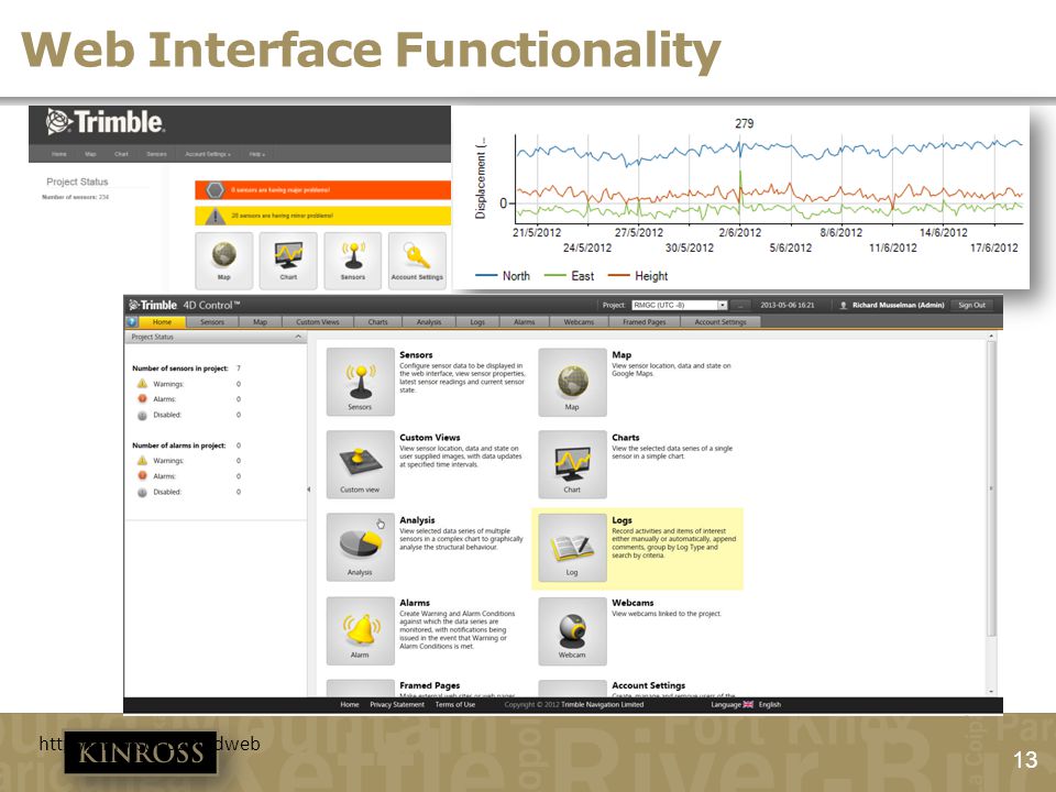
Web Interface Functionality
14
Historical Data Integration
Before After Average Amplitude 0.70 ft 0.13 ft Measurements/day/prism 4 11

15
Why is slope monitoring valuable?

16
Protect Property? 3 electric shovels 14 haul trucks

17
Maintain Production?

18
Putting People First Rigorous Financial Discipline
High Performance Culture Outstanding Corporate Responsibility

Similar presentations


