Download presentation
Presentation is loading. Please wait.

1
Mesoscale Banded Precipitation EAX Winter Weather Workshop 28 October 2008 EAX Winter Weather Workshop 28 October 2008

2
Norwegian Cycle Model

3
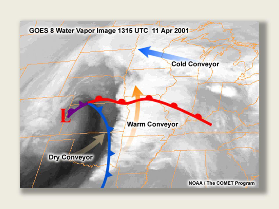
Relatively narrow ribbons of air flowing along sloping isentropic surfaces Represent air trajectories Produce clouds and precipitation Three conveyor belts or airstreams: Warm – transports warm air poleward - lifts warm/moist air over warm front Cold – runs parallel to the warm front on the cold side Dry – descending air stream on the southwest or backside of system Conveyor Belt - Overview

5
WCB – locate ribbon of strongest winds starting in the warm sector near highest RH and extend parallel along θe lines until they reach RH max.

6
CCB begins where easterly flow becomes sufficiently deep…..note the slope

7
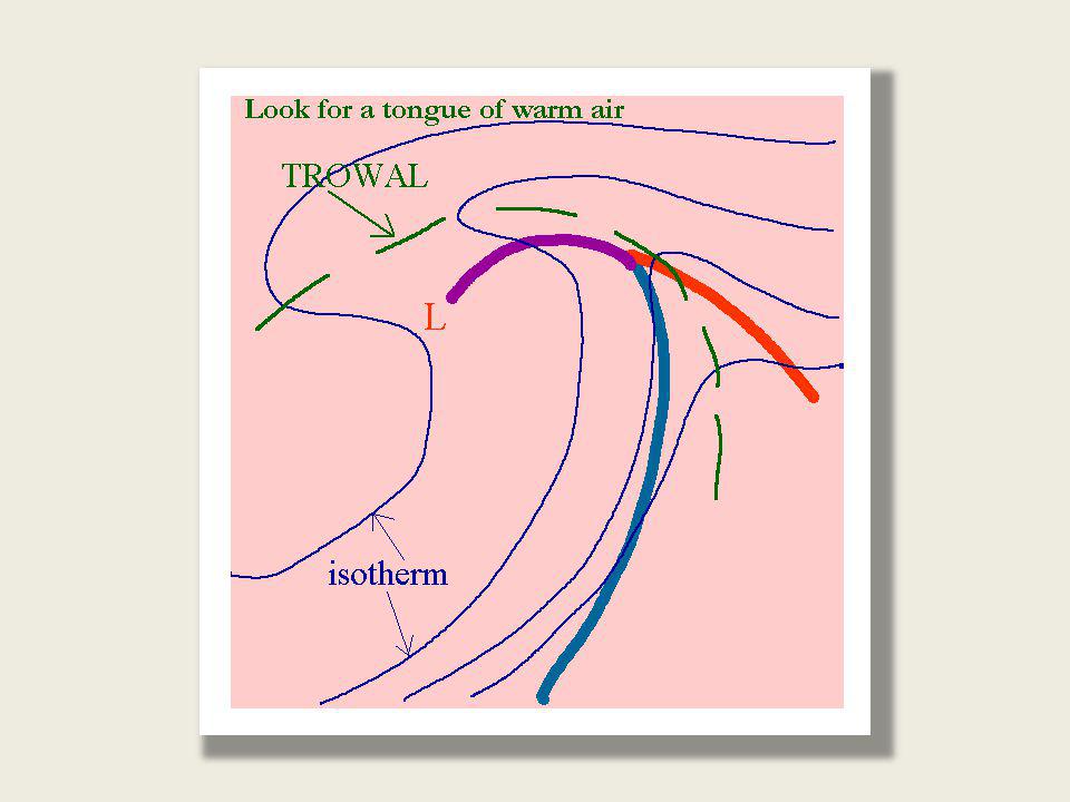
TROWAL (Warm Conveyor Belt) – Mature Cyclone Portion of WCB turns cyclonically and is pulled into the circulation Creates a trough of warm air aloft (TROWAL) Narrow and focused – gives rise to banded precipitation
 – Mature Cyclone Portion of WCB turns cyclonically and is pulled into the circulation Creates a trough of warm air aloft (TROWAL) Narrow and focused – gives rise to banded precipitation")
10
TROWAL is a sloping canyon Best seen on mid-level θe surfaces (800-600mb) Ascending warm air Feature of occluded systems Strong frontogenesis Wrap-around part of cyclone Enhances precipitation associated with comma head
 Ascending warm air Feature of occluded systems Strong frontogenesis Wrap-around part of cyclone Enhances precipitation associated with comma head")
12
Dont underestimate……… Warm Air Advection!! (shameless plug)
")
13
5 year cold season climatology Axes of snowbands relative to cyclone Heavy precipitation bands: Occluded wrap around portion of cyclone Far from warm and cold fronts

15
Midlevel Theta-e

16
How to find a TROWAL with a X-Section

17
Wheres the TROWAL?

18
November 29-30, 2006 Snow/Ice Storm Clinton, MO - 18" Butler, MO - 18" Blairstown, MO - 18" Sedalia, MO - 16" Moberly, MO - 15" Boonville, MO - 15 MCI – dusting Southern Johnson/Jackson – 10

21
Horizontal Divergence Divergence (Convergence) acts frontolytically (frontogenetically), always, irrespective of isotherm orientation. F<0F>0

22
What is Deformation? Process by which an air stream tends to stretch or alter the distribution of a tracer such as moisture. Monitor for banded precipitation Can result in frontogenesis…..this can force precipitation into narrow bands One method is two opposing air streams at mid or upper levels are directed towards each other. As they approach they split and fan out in a different pattern.

27
Sloped Continuity of Frontogenesis (F) 6hr ETA forecast valid 18z 15 OCT 01 Presence of parallel axes of positive frontogenesis sloping upward toward colder air is a common aspect of heavy banded precipitation areas. 600mb 700mb 850mb

28
Sloped Continuity of Frontogenesis Forcing (cont.) Several Important Implications: 1)Do NOT rely on any single level of frontogenesis to forecast an area of expected banded snow. 2)Several levels should be assessed for spatial continuity and orientation of F, to see if banding is likely to occur at a given time. 3)The sloped continuity tells us something about the structure of the wind field we can use to infer frontogenesis from single sounding (observed or model derived), VAD, or wind profiler data, and large- scale flow fields.
Several levels should be assessed for spatial continuity and orientation of F, to see if banding is likely to occur at a given time. 3)The sloped continuity tells us something about the structure of the wind field we can use to infer frontogenesis from single sounding (observed or model derived), VAD, or wind profiler data, and large- scale flow fields..")
29
Role of Deep-Layer Shear Profile Nature of environmental wind profile may be conducive to seeder-feeder mechanism and rapid precipitation generation / elongation of bands during initial development phase.

32
Cooling Induce Downdrafts Evaporation and melting induced circulations act to force precipitation into mesoscale bands. Atmosphere cools/moistens from top downward. Near the surface, frozen precipitation melts/ evaporates in the dry layer. After saturation layer can still cool via melting which robs the atmosphere of heat energy. Continuous precipitation within a synoptic setting results in a continuous downdraft.

33
Cooling-Induced Frontogenesis Cooling the air increases the temp gradient. Resulting frontogenesis strengthens vertical motions. Melting and evaporation lead to convergence at the surface. Warm air up & over cold air creates mesoscale version of cold front resulting in banded precipitation. Begins as rain Changes to snow Heaviest pcpn along frontal zone near the 0°C surface wet bulb isotherm.

34
Locate the Deformation axis…… Frontogenesis

35
Answer

36
Precipitation Aligns with Axis of Dilation

39
When applied within the context of ingredients based forecasting, frontogenesis (F) is useful for assessing potential for banded winter precipitation. Doesnt require a strong cyclone, only a strong baroclinic zone, often developed through horizontal deformation and associated largely with unidirectional vertical shear in the low to mid levels. Sloped continuity in time and space of F leads most directly to strong banded precipitation. Best practice: interrogate 50mb layers of F starting with 800-850mb. AWIPS 4-panel procedure has been created under user ID winter. Look for unidirectional deep layer shear under 700mb as an indication that F may be significant……evaluate VWP, wind profilers, progged soundings. When frontogenesis is acting, precipitation will be aligned with the deep layer shear vector. Look for a TROWAL (warm conveyor belt) and locate its presence in the nw quadrant of the upper system lying within the deformation zone. Summary
 and locate its presence in the nw quadrant of the upper system lying within the deformation zone. Summary.")
41
November 29-30, 2006 Snow/Ice Storm Clinton, MO - 18" Butler, MO - 18" Blairstown, MO - 18" Sedalia, MO - 16" Moberly, MO - 15" Boonville, MO - 15 MCI – dusting Southern Johnson/Jackson – 10

Similar presentations


 abrupt cooling as it passes Warm Front:warm air behind front (often to S) more gradual warming.>")


