Download presentation
Presentation is loading. Please wait.

1
Long-term monitoring of large, remote areas with minimal funding: hope and encouragement for natural area managers Steven Fancy National Monitoring Program Leader National Park Service

2
State of the Parks Report (circa 2000) 80 (1/3) of the natural resource parks had no professional natural resource manager Another 84 parks had only 1 or 2 natural resource professionals. Almost all projects/studies were short-term; staff mostly deals with the crisis of the day. Sampling designs mostly done by expert opinion representative sites or convenience. No TimeNo Money No Clue

3
NPS Natural Resource Challenge Accelerate Inventories Design/Implement Vital Signs Monitoring Collaboration with scientists and others Improve Resource Planning Enhance Parks for Science Assure Fully Professional Staff Control Non-native Species Protect Native and Endangered Species Enhance Environmental Stewardship Expand Air Quality efforts Protect and restore Water Resources Establish Research Learning Centers Revitalize and expand the natural resource program within the NPS & improve park management through greater reliance on scientific knowledge

4
Economics 101 Without integration and cost-sharing, parks can only monitor a few things; too few to adequately track condition of resources; Park buy-in and cost-leveraging through partnerships are critical; must be relevant to park managers and flexible to allow integration and partnerships; Establish 32 monitoring networks that share funding and staffing among parks to gain efficiencies and consistency. Funding level (avg. $100,000 per park) would allow each park to hire one professional position (GS-9 or 11) plus about $30-40 K operating $$ Conclusions/Strategy:
 would allow each park to hire one professional position (GS-9 or 11) plus about $30-40 K operating $$ Conclusions/Strategy:.")
5
The Wedding Cake An alternative to One Size Fits All National Park Servicewide Core Variables Network/Ecosystem Core Variables Network/Ecosystem Primary use of data is at local level for park management Indicators and protocols most relevant to each system are very different; e.g., Northwest Forests vs. South Florida vs. Colorado Plateau Cost-leveraging through Opportunity very important for early success and efficiency

6
Spatial Sampling Designs Why do we Need Them? We can only sample a very small proportion (often <1%) of most natural areas; but, Our job is to protect, restore, understand, and inform others about the entire area, not just some convenient portion of it. Need to make scientifically-defensible inferences to areas beyond the actual areas we sample. Statistical, design based inferences can only be made to areas that have a chance of being included in the sample. Especially important because we are designing LONG-TERM MONITORING
 of most natural areas; but, Our job is to protect, restore, understand, and inform others about the entire area, not just some convenient portion of it. Need to make scientifically-defensible inferences to areas beyond the actual areas we sample. Statistical, design based inferences can only be made to areas that have a chance of being included in the sample. Especially important because we are designing LONG-TERM MONITORING.")
7
Reality Check: Sometimes you just cant get there

8
Take Home Messages A few Lessons Learned about Sampling Design for Long-term Monitoring Design should allow inferences to entire park, not just some accessible portion of it Some sort of probability sample should always be taken, even if you can only start with very small sample sizes Judgement sampling, using representative sites selected by experts, should be avoided Do not stratify on biological criteria (e.g., vegetation maps). Use stratification sparingly, if at all Permanent plots that are revisited over time are recommended to increase precision It is not necessary to visit plots every year - rotating panels increase sample size Co-locate sample sites for various components of the monitoring program

9
Three Examples: 2-stage mini-grid design for Central Alaska Network – 3 parks >21 Million acres (size of Indiana) GRTS design – large river parks in Missouri and Arkansas Unequal probability sampling of upland sites in Northern Colorado Plateau parks (site selection based on accessibility, climate, geology and soils)
 GRTS design – large river parks in Missouri and Arkansas Unequal probability sampling of upland sites in Northern Colorado Plateau parks (site selection based on accessibility, climate, geology and soils)")
10
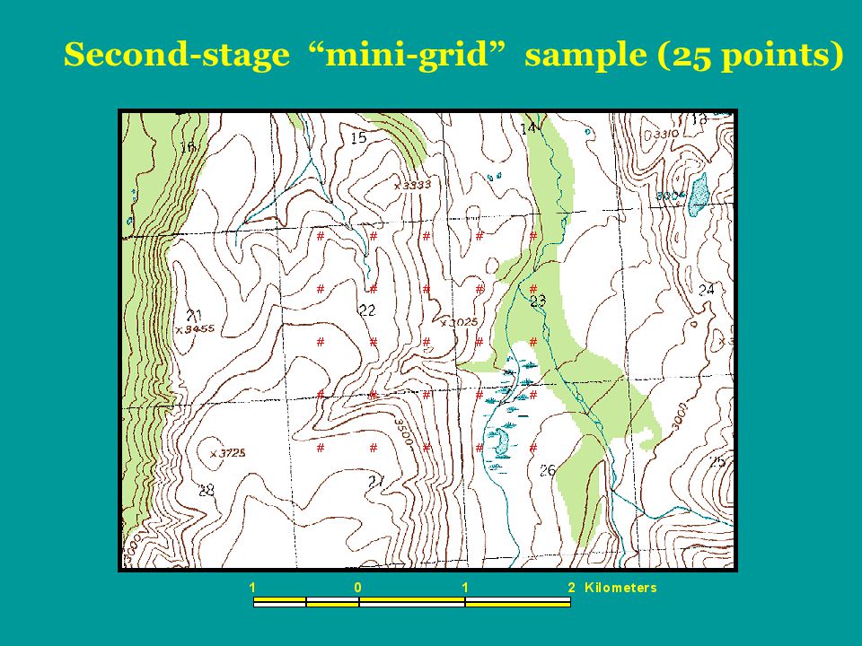
First-stage systematic grid with 20 km spacing

13
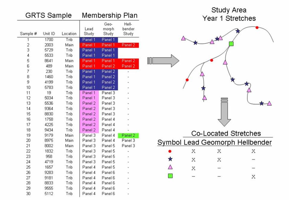
Buffalo River Streams: 100 sites Geomorphology Aquatic Macroinvertebrates Fish Communities Ozark Hellbender (giant salamander, T&E) Mercury Lead Sampling of stream segments with co-location and co- visitation among monitoring indicators:
 Mercury Lead Sampling of stream segments with co-location and co- visitation among monitoring indicators:")
16
Northern Colorado Plateau Network (NCPN) Sampling Design
 Sampling Design")
17
Collocated Vital Signs – vegetative structure, composition, condition of focal communities; soil/site stability; upland-hydrologic function; soil-crust structure; nutrient cycling Integrated Upland Sampling Design - NCPN Systematic grid of points (50-m spacing) overlaid on park used to define anchor points of sampling plots Unequal probability of selection of sampling plots provides ability to add sites in the future (if needed) probability defined by accessibility (high, low) probability defined by climate, soils, and geology (rel. static surrogate for vegetative communities)
.")
18
A split-panel design will be employed that features spatial interpenetration the ability to evaluate inter-annual variability a balance between trend and status assessments And that meets Vital Sign sampling objectives Integrated Upland Sampling Design – NCPN Temporal Design

19
Split panel [(2-7) 9, (1-8) 9 ] X 9 X 8 X 7 X 6 X 5 X 4 X 3 X 2 XX 1 XXX 9 X X 8 X X 7 X X 6 X X 5 X X 4 X X 3 X X 2 X X X 1 10…987654321Year/ Panel X = 10 plots; 30 plots per year spatially distributed ca. equally among 4 Ecosites
![Split panel [(2-7) 9, (1-8) 9 ] X 9 X 8 X 7 X 6 X 5 X 4 X 3 X 2 XX 1 XXX 9 X X 8 X X 7 X X 6 X X 5 X X 4 X X 3 X X 2 X X X 1 10… Year/ Panel X = 10 plots; 30 plots per year spatially distributed ca.](http://images.slideplayer.com/5/1561118/slides/slide_19.jpg "equally among 4 Ecosites.")
20
Weight of Evidence

21
http://science.nature.nps.gov/im/monitor

23
Take Home Messages A few Lessons Learned about Sampling Design for Long-term Monitoring Design should allow inferences to entire park, not just some accessible portion of it Some sort of probability sample should always be taken, even if you can only start with very small sample sizes Judgement sampling, using representative sites selected by experts, should be avoided Do not stratify on biological criteria (e.g., vegetation maps). Use stratification sparingly, if at all Permanent plots that are revisited over time are recommended to increase precision It is not necessary to visit plots every year - rotating panels increase sample size Co-locate sample sites for various components of the monitoring program A scientifically-defensible sampling design can be done, and it should be done. Assistance and examples are available from others.

Similar presentations