Download presentation
Presentation is loading. Please wait.

3
Lowermost Pajaro left-bank bench vegetation just downstream from Thurwatcher Bridge

7
Corralitos Creek above Salsipuedes ~ 1910?

8
Salsipuedes & Corralitos Junction

12
Murphys Crossing: view downriver

13
View upstream – big bend just west of Aromas Important flood storage area

14
Probably near Aromas ~1915 view upstream

15
View downstream at Aromas - quarry product spills from railroad r-o-w?

16
View Downstream over Chittenden - Soda Lake Meander Scars

17
Future site of Graniterock Wilson Quarry (left) - view downstream
 - view downstream")
18
Railroad Bridge at Chittenden with 1906 faulting repairs USGS photo

20
Upper Pajaro River joining lower San Benito River - view east

21
Upper Pajaro River (right) joining San Benito River (foreground) View west (downstream)
 joining San Benito River (foreground) View west (downstream)")
22
July 1952

24
Lower San Benito - pre-mining June, 1939

26
Hillsdale sand and gravel. View upriver

27
Bench height 142; river bed 132; berm height 157-170 December 2000

28
View upstream Hillsdale quarry. February, 2004

29
View downstream Hillsdale Quarry

30
Crossing berm was 13+ ft high in December, 2000

31
Haul Road berm ~4-10 feet high - view south to San Juan Bautista

33
Channel isolated in old spoils disposal and mining area

34
Overview Dec 2000 (A = Abandoned flood plain segments) Hillsdale Quarry site - San Benito River
 Hillsdale Quarry site - San Benito River")
35
Gravel skimming and stream-bed mining - view south

36
Past stream-bed mining site, and present mountain-top removal site for Hillsdale plant. View northwest. Banks 10ft and stable.

37
View southwest (downstream) moving up into bank cutting areas
 moving up into bank cutting areas")
38
Lower Lucy Brown Lane reach. Bed of river here mined about 10-15 ft below grade. Left bank erodes in floods (~15 ft high)
.")
39
Lucy Brown lower reach view of right bank 15-40 ft high

40
Lower Lucy Brown reach - left bank active bank cutting 20 ft high

41
Bank cutting and slumping just downstream from Lucy Brown Ln - View downstream

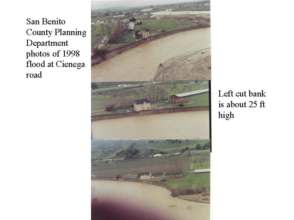
42
Bank cutting and slumping just downstream from Lucy Brown

43
Slump along right bank - lower Lucy Brown stream bed mining reach

44
Upper Lucy Brown Ln reach - operator shut down in 2002 View southwest of left bank 25 ft high

45
Narrowest point on lower San Benito River - excavated channel

47
Low berms do not protect closed plant site

49
Sod Farm site - view west. Floodplains being abandoned but carried floodwater in 1995 and 1998

50
Small berm protects sod farm from 1-10 yr events - view west

51
Mitchell Road 1 km wide reach - flow to left

54
View upstream (south). Hwy 156 bypass; and Hwy 156 commercial (background) with two sewage pond sites in historic floodplain.
 with two sewage pond sites in historic floodplain..")
55
New Highway 156 bridge near Mitchell Road reach and lower pond complex protected by berms in floodplain. View north.

56
USGS gauging site (rt bank) along old Hwy 156, Hollister
 along old Hwy 156, Hollister")
57
Upper Hollister sewage ponds stable channel

59
Same site of destroyed bridge

60
Same site in summer when a temporary crossing is built View upstream

61
Heavy vehicle use in channel - view downstream to Hollister

62
Union Rd. bridge, view north downstream. Cienega Rd, Hollister

63
Union Rd. bridge - view upstream. Banks 20-25 ft high, actively cut.

64
Ditto - view downstream

65
Site of Cienega Road house site where 40+ feet of bank 25 ft high was lost in 1998. View upstream to Hospital Road seasonal crossing.

66
Cienega Road house site with two cutting left bank levels

68
Right bank material may be mining spoils - about 20 ft high

70
Basal left and right bank alluvium

71
Old quarry site with berms in the channel just above Hospital Road Seasonal crossing site. Gravel processing site was upper left

73
Failing banks at site of past river bed mining just downstream from Tres Pinos Creek tributary. View of right bank ~ 20 ft high.

74
Natural slump (reactivated in 1995) near Tres Pinos Creek - View South
 near Tres Pinos Creek - View South")
75
Ditto - this is a source of gravel-sized materials - Left Bank

76
Tres Pinos Quarry, Tres Pinos Ck. Right bank terrace mining; floodplain disposal

77
Tres Pinos Creek, view upstream - disposal in floodplain of fine spoils

Similar presentations