Download presentation
Presentation is loading. Please wait.

1
GROUND BASED AUGMENTATION SYSTEM System Overview Christophe DEHAYNAIN Direction Générale de l’Aviation Civile FRANCE

2
GROUND BASED AUGMENTATION SYSTEM Presentation Overview
Why do we need an augmentation to GNSS ? Local Area Differential GNSS Principle GBAS Ground Segment GBAS Airborne Segment Conclusions

3
GBAS Concept System Overview
ICAO Name : GBAS for Ground Based Augmentation System Operational Coverage : minimum : same as ILS recommended : Omni directional (radius 23 NM) up to FL 100 and down to 12 ft Data-Link Frequency range : MHz (25 kHz spacing) Operational objective : minimum : Category 1 approach optional : 2 D navigation (Positioning Service) Localisation : Airport
 up to FL 100 and down to 12 ft. Data-Link Frequency range : MHz (25 kHz spacing) Operational objective : minimum : Category 1 approach. optional : 2 D navigation (Positioning Service) Localisation : Airport.")
4
GBAS Overview Do not mistake GBAS for :
DGPS, LADGPS : initial US generic names for GBAS concept SCAT1 or Special Category 1 : US RTCA standard defining a non-interoperable system for private use LAAS : Local Area Augmentation System : present US name for GBAS

5
WHY GNSS NEEDS AN AUGMENTATION ?
GPS Only Civil Aviation PERFORMANCE CATEGORY I Requirements H. 13 m V. 23 m ACCURACY (95%) H 16.0 m V 4.0 m 99% (RAIM) AVAILABILITY 99.75 % 3,5.10-7/ approach Time to alarm 6 s ? INTEGRITY ? CONTINUITY OF SERVICE 10-4 / approach (10-5 / 15 s)
 H 16.0 m. V 4.0 m. 99% (RAIM) AVAILABILITY % 3,5.10-7/ approach. Time to alarm 6 s. INTEGRITY. CONTINUITY OF SERVICE / approach. (10-5 / 15 s)")
6
LOCAL AREA DIFFERENTIAL PRINCIPLE I - Basic Principle
Measurements made by two receivers are affected by the same errors as long as these two receivers are not too far from each other RX2 RX1

7
LOCAL AREA DIFFERENTIAL PRINCIPLE II - Differential Correction Calculation
Broadcast SV Position Actual SV Position Measured Pseudoranges Calculated Range REF USER Corrections Calculation Differential Message Broadcast Known Reference Location The first receiver in a reference station can calculate these errors knowing its exact location (corrections calculated by the GBAS ground station) The second receiver (the user) will use these corrections to correct its own measurements and increase the accuracy of these measurements Calcul simplifié pour la démonstration Modèles atmosphériques non appliqués
 The second receiver (the user) will use these corrections to correct its own measurements and increase the accuracy of these measurements. Calcul simplifié pour la démonstration. Modèles atmosphériques non appliqués.")
8
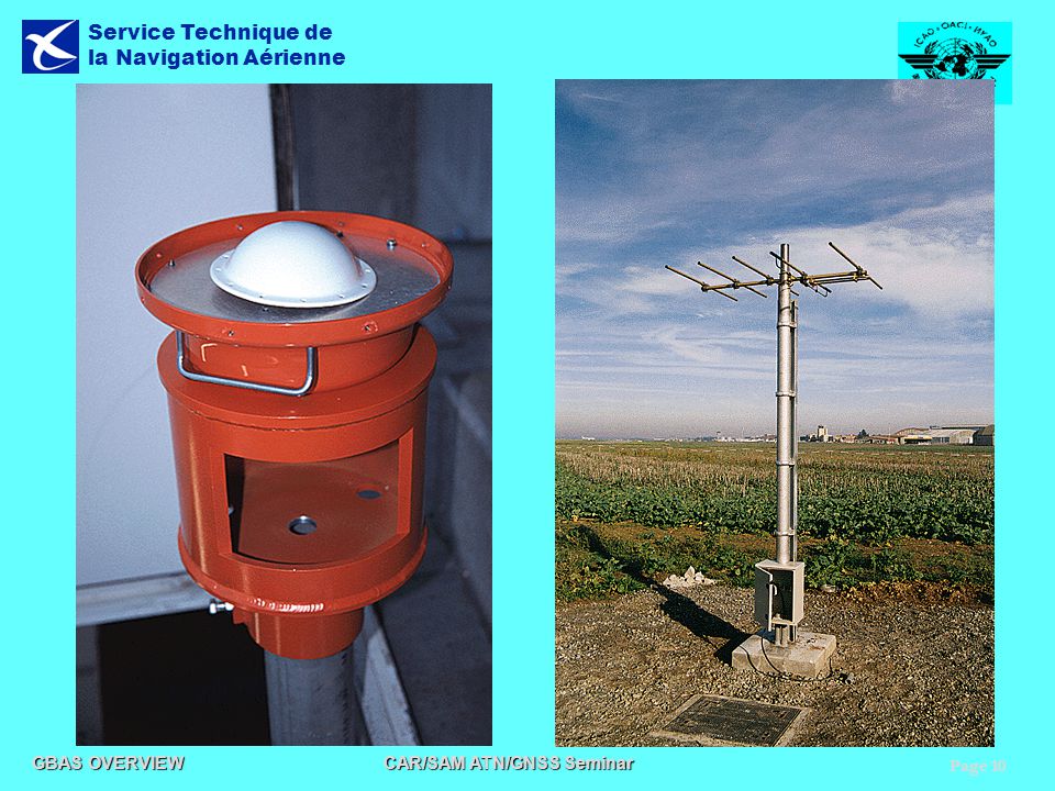
GBAS ground segment I - Basic architecture of a reference station
GPS/GLONASS Antennas Differential Message Broadcast Antenna Receiving Unit (up to 4 Reference Receivers) Data Broadcast Unit Data processing for broadcast Raw Data PR, ephem.,time Unités rassemblées dans le même ensemble ou éclatées sur le terrain Data Processing Unit Differential Corrections Calculation Integrity Monitoring Functions GBAS Messages Elaboration
 Data Broadcast Unit. Data processing for broadcast. Raw Data. PR, ephem.,time. Unités rassemblées dans le même ensemble ou éclatées sur le terrain. Data Processing Unit. Differential Corrections Calculation. Integrity Monitoring Functions. GBAS Messages Elaboration.")
11
GBAS ground segment II - VHF Data Broadcast (VDB)
GBAS VDB characteristics : VHF NAV band ( MHz), channel spacing 25 kHz D8PSK (Differential 8 States Phase Shift Keying) modulation 2 Hz update rate (Pseudorange Corrections) 8 slots Time Division Multiple Access technique (16 per second) Horizontal Polarisation or Elliptical Polarisation (Recommendation) 50W ground transmitter power (Typically power for HPOL) Omni-directional antenna Coverage: 23 NM radius
, channel spacing 25 kHz. D8PSK (Differential 8 States Phase Shift Keying) modulation. 2 Hz update rate (Pseudorange Corrections) 8 slots Time Division Multiple Access technique (16 per second) Horizontal Polarisation or Elliptical Polarisation (Recommendation) 50W ground transmitter power (Typically power for HPOL) Omni-directional antenna. Coverage: 23 NM radius.")
12
GBAS ground segment III - VDB message content
The current SARPS require the transmission of three message types : Differential Code Corrections and integrity Data Reference Point and GBAS Data Final Approach Path description

13
GBAS ground segment IV - GBAS Ground System Classification
The global performances of Ground System are linked to : the Number of installed GNSS receivers (2 to 4) The quality of the GNSS signal reception A Ground Accuracy Designator (GAD) will qualified the ground segment
 The quality of the GNSS signal reception. A Ground Accuracy Designator (GAD) will qualified the ground segment.")
15
GBAS User segment I-Basic operations
GBAS will be basically used as an ILS (ILS Look-alike concept) RNAV 2D operations may be developed if the Ground System support the Positioning Service
 RNAV 2D operations may be developed if the Ground System support the Positioning Service.")
16
GBAS User segment II-Airborne Equipment
Multi-mode Receivers (MMR) and their associated GPS and VHF antennas will be used for GBAS approaches No hardware update is foreseen (Software only)
 and their associated GPS and VHF antennas will be used for GBAS approaches. No hardware update is foreseen (Software only)")
17
Conclusions The GBAS system as standardised in ICAO Annex 10 is able to serve Cat-I operations. Advanced operations such as Cat-II/III or A-SMGCS are under consideration by ICAO GNSS Panel GBAS ground stations are being built, are considered in several implementation programmes in the World GBAS airborne equipment are being developed within Multi-Mode Receiver are considered in several aircraft manufacturer programmes Standards Status ICAO Standards (SARPS) are available Other Standards (Doc 4444, Doc 8071, PANS OPS) are being finalised Industry Standards (MOPS) are being developed and will be soon available
 are available. Other Standards (Doc 4444, Doc 8071, PANS OPS) are being finalised. Industry Standards (MOPS) are being developed and will be soon available.")
Similar presentations


 International Civil Aviation Organization Spectrum Seminar Nairobi, Kenya February 17-19,>")

>")


