Download presentation
Presentation is loading. Please wait.

1
Utah’s landforms

2
Mountain A landform that rises very tall above its surrounding landscape and is higher than a hill. Mountains have steep slopes and a peak. A mountain range is a group of mountains that were formed in the same way at the same time.

3
Valley ©wikipedia A large area of low-lying land found in between hills or mountains and usually having a river or stream flowing along its bottom.

4
Utah Valley

5
Canyon ©Dr. Cagan Sekercioglu A canyon is a narrow, deep, rocky, and steep-walled valley carved by a swift-moving river. Most canyons were formed by a process of long-time erosion from a plateau level.

6
Plateau A flat, large area of land that rises some 1,500 feet or more
©Dr. Cagan Sekercioglu A flat, large area of land that rises some 1,500 feet or more above its surroundings and has at least one steep side.

7
Mesa & Butte Mesa—A large, table-like landform .
I’m a mesa I’m a butte ©chrishphoto Mesa—A large, table-like landform . Butte—A table-like landform like a mesa, but smaller in size. Both are the result of plateau erosion.

8
River ©Dr. Cagan Sekercioglu A natural stream of water, flowing toward the ocean, a lake, or another stream. In some cases a river flows into the ground or dries up completely before reaching any other water body.

9
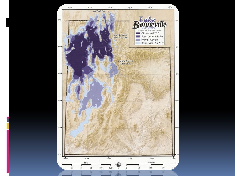
Lake A body of water surrounded by land. Salt Lake is what’s left of the massive Ancient Lake Bonneville. The lake is now landlocked and its waters are salty. It is the largest lake between the Great Lakes and the Pacific Ocean, and is the largest saltwater lake in the Western Hemisphere.

10
Peninsula Land surrounded by water on three sides.

11
Salt Flat Dried up lake bed from a salty lake named Lake Bonneville.
©wikipedia Dried up lake bed from a salty lake named Lake Bonneville. The Bonneville Salt Flats and the Great Salt Lake are remnants of ancient Lake Bonneville. Wind and water combine to create the flat surface of salt. Each winter, a shallow layer of standing water floods the surface of the salt flats. During spring and summer, the water slowly evaporates while winds smooth the surface into a vast, nearly perfect flat plain.

12
Island An island is a piece of land that is surrounded by water.

13
Sand dune Wind-blown piles of sand that can reach
Wind-blown piles of sand that can reach heights of up to 1,640 feet.

14
Basin A bowl-like area of land usually surrounded by Mountains
A bowl-like area of land usually surrounded by Mountains with no outlet for water.

15
Volcano ©wikipedia An opening in the earth’s crust through which molten lava, ash, and gasses are ejected.

18
©greatsaltlakephotos.com

Similar presentations