Download presentation
Presentation is loading. Please wait.

1
Vehicle Tracking Remote Control & Monitoring System

2
System Components Vehicle Tracking Unit Vehicle Tracking Unit Receiver Software Application (on our server) Receiver Software Application (on our server) Google Earth (free version) Google Earth (free version) Locator Web-Application Locator Web-Application Report Generator Report Generator Geofencing Geofencing Alert Notification Alert Notification
 Receiver Software Application (on our server) Google Earth (free version) Google Earth (free version) Locator Web-Application Locator Web-Application Report Generator Report Generator Geofencing Geofencing Alert Notification Alert Notification")
3
Vehicle Tracking Unit GPS Module with High sensitive GPS builtin Antenna GPS Module with High sensitive GPS builtin Antenna GSM 850/900/1800/1900 Quad Band builtin Antenna GSM 850/900/1800/1900 Quad Band builtin Antenna Compact and waterproof design Compact and waterproof design Microcontroller and Memory Microcontroller and Memory Power Supply wide foltage input range Power Supply wide foltage input range Built-in vibration senser, theftproof. Ignition detection. Built-in vibration senser, theftproof. Ignition detection. Tele-cutoff (petrol / electricity) function Tele-cutoff (petrol / electricity) function SOS alarm and burglar alarm SOS alarm and burglar alarm Voicemonitor function Voicemonitor function Power off alarm with Backup battery Power off alarm with Backup battery Compatible with eternal connection through serial port Compatible with eternal connection through serial port
 function Tele-cutoff (petrol / electricity) function SOS alarm and burglar alarm SOS alarm and burglar alarm Voicemonitor function Voicemonitor function Power off alarm with Backup battery Power off alarm with Backup battery Compatible with eternal connection through serial port Compatible with eternal connection through serial port.")
4
GPS (Global Positioning System) Free satellite-based navigation system Free satellite-based navigation system GPS works in any weather conditions GPS works in any weather conditions GPS works anywhere in the world GPS works anywhere in the world GPS 24 hours a day GPS 24 hours a day The satellites emit encoded navigational information (exact positioning and exact time) The satellites emit encoded navigational information (exact positioning and exact time) the receiver calculates its own longitude, latitude, acceleration, velocity and even altitude to within a few meters the receiver calculates its own longitude, latitude, acceleration, velocity and even altitude to within a few meters
 Free satellite-based navigation system Free satellite-based navigation system GPS works in any weather conditions GPS works in any weather conditions GPS works anywhere in the world GPS works anywhere in the world GPS 24 hours a day GPS 24 hours a day The satellites emit encoded navigational information (exact positioning and exact time) The satellites emit encoded navigational information (exact positioning and exact time) the receiver calculates its own longitude, latitude, acceleration, velocity and even altitude to within a few meters the receiver calculates its own longitude, latitude, acceleration, velocity and even altitude to within a few meters")
5
GPRS Modem Service available through mobile networks Service available through mobile networks Data compressed to minimize communication cost Data compressed to minimize communication cost Monthly fee not to exceed 10 SR per vehicle (subject to the local tariff) Monthly fee not to exceed 10 SR per vehicle (subject to the local tariff) Builtin antenna Builtin antenna
 Monthly fee not to exceed 10 SR per vehicle (subject to the local tariff) Builtin antenna Builtin antenna")
6
Microcontroller and Memory Microcontroller controls the unit functionality Microcontroller controls the unit functionality Functionality easy to be modified or upgraded by altering the internal program Functionality easy to be modified or upgraded by altering the internal program Microcontroller easy to be reprogrammed wirelessly using Over The Air Upgrade feature Microcontroller easy to be reprogrammed wirelessly using Over The Air Upgrade feature

7
Memory All readings are saved in the internal memory prior to be sent All readings are saved in the internal memory prior to be sent Guarantee not to lose any information in case of GSM signal loss Guarantee not to lose any information in case of GSM signal loss Enough memory to save the readings of 2 regular working days Enough memory to save the readings of 2 regular working days

8
I/O Interface (optional feature) Can read data from inside the vehicle like: Can read data from inside the vehicle like: - Fuel level - Fuel consumption - Temperature - Seat belt status - Door status - Compressor status
 Can read data from inside the vehicle like: Can read data from inside the vehicle like: - Fuel level - Fuel consumption - Temperature - Seat belt status - Door status - Compressor status")
9
I/O Interface (continued) - Humidity - Pressure - Weight - Torque - Object Movement (linear displacement/rotation) - 2D/1D inclination - Air/Liquid Flow - Biometric (fingerprint) - Access Control - RFID - Etc …
 - Humidity - Pressure - Weight - Torque - Object Movement (linear displacement/rotation) - 2D/1D inclination - Air/Liquid Flow - Biometric (fingerprint) - Access Control - RFID - Etc …")
10
Serial Port (RS 232) Easy connection to any PC for reprogramming and data retrieval Easy connection to any PC for reprogramming and data retrieval Internet access through the GPRS modem (optional feature) Internet access through the GPRS modem (optional feature) Connection to satellite modem for areas not covered with GSM network (optional feature) Connection to satellite modem for areas not covered with GSM network (optional feature)
 Easy connection to any PC for reprogramming and data retrieval Easy connection to any PC for reprogramming and data retrieval Internet access through the GPRS modem (optional feature) Internet access through the GPRS modem (optional feature) Connection to satellite modem for areas not covered with GSM network (optional feature) Connection to satellite modem for areas not covered with GSM network (optional feature)")
11
Serial Port (RS 232) (continued) Connection to Vehicle Bus thru external interfaces: Connection to Vehicle Bus thru external interfaces: - CAN Bus - SAE J1708 - Etc …
 (continued) Connection to Vehicle Bus thru external interfaces: Connection to Vehicle Bus thru external interfaces: - CAN Bus - SAE J Etc …")
12
Receiver Software Application Runs on a dedicated server Runs on a dedicated server Uncompress the readings received from the units Uncompress the readings received from the units Data is saved on MS SQL database Data is saved on MS SQL database Possibility to archive old data Possibility to archive old data User definition and access right User definition and access right Adding new units to the system Adding new units to the system

13
Google Earth (free version) Available for free Available for free Detailed maps are available to all the areas worldwide Detailed maps are available to all the areas worldwide Maps are renewed and updated periodically for free Maps are renewed and updated periodically for free Possibility to save the clients locations and locations of interest on the map using the multi- layer feature of Google Earth Possibility to save the clients locations and locations of interest on the map using the multi- layer feature of Google Earth Import/Export the saved locations Import/Export the saved locations Link the location saved with any type of files (memo, image, salesperson, etc … ) Link the location saved with any type of files (memo, image, salesperson, etc … )
 Available for free Available for free Detailed maps are available to all the areas worldwide Detailed maps are available to all the areas worldwide Maps are renewed and updated periodically for free Maps are renewed and updated periodically for free Possibility to save the clients locations and locations of interest on the map using the multi- layer feature of Google Earth Possibility to save the clients locations and locations of interest on the map using the multi- layer feature of Google Earth Import/Export the saved locations Import/Export the saved locations Link the location saved with any type of files (memo, image, salesperson, etc … ) Link the location saved with any type of files (memo, image, salesperson, etc … )")
14
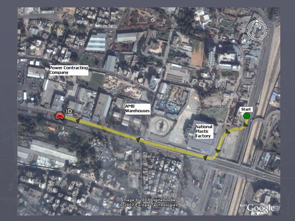
Locator Web-Application Works with Google Earth or any other digital map application Works with Google Earth or any other digital map application Locates the position of one or more vehicles on the map Locates the position of one or more vehicles on the map Tracks the movement of the vehicle on-line Tracks the movement of the vehicle on-line Draws the path of the vehicle on-line Draws the path of the vehicle on-line Draws the path of the vehicle for any specific period of time Draws the path of the vehicle for any specific period of time

16
Locator Web-Application (continued) Shows the readings received from the unit on-line Shows the readings received from the unit on-line Shows the vehicle stops and the duration and timing of each stop Shows the vehicle stops and the duration and timing of each stop Displays the average speed, maximum speed and the location where the maximum speed occurred within the drawn track Displays the average speed, maximum speed and the location where the maximum speed occurred within the drawn track Calculates the traveled distance for a specific track Calculates the traveled distance for a specific track
 Shows the readings received from the unit on-line Shows the readings received from the unit on-line Shows the vehicle stops and the duration and timing of each stop Shows the vehicle stops and the duration and timing of each stop Displays the average speed, maximum speed and the location where the maximum speed occurred within the drawn track Displays the average speed, maximum speed and the location where the maximum speed occurred within the drawn track Calculates the traveled distance for a specific track Calculates the traveled distance for a specific track")
17
Reports Various standard reports available: Various standard reports available: - Speed - Stops - Distance traveled - Summary Daily Activities - Fuel level and consumption - Visits to clients and saved locations - Summary driver performance

19
Reports (continued) Adding new customized reports (optional feature) Adding new customized reports (optional feature) Report for one or more vehicle Report for one or more vehicle Export to Excel Export to Excel Viewing in tabular or graphical format Viewing in tabular or graphical format
 Adding new customized reports (optional feature) Adding new customized reports (optional feature) Report for one or more vehicle Report for one or more vehicle Export to Excel Export to Excel Viewing in tabular or graphical format Viewing in tabular or graphical format")
20
Geofencing (optional feature) Virtual geographical boundary Virtual geographical boundary Easily configured Easily configured For one vehicle or a group of vehicles For one vehicle or a group of vehicles Reverse Geofence Reverse Geofence
 Virtual geographical boundary Virtual geographical boundary Easily configured Easily configured For one vehicle or a group of vehicles For one vehicle or a group of vehicles Reverse Geofence Reverse Geofence")
22
Alert Notification (optional feature) Configurable Alert Notification Configurable Alert Notification - Speed Violation - Special Engine condition - Geofence crossing - Etc … Notification thru SMS Notification thru SMS Notification thru Email Notification thru Email
 Configurable Alert Notification Configurable Alert Notification - Speed Violation - Special Engine condition - Geofence crossing - Etc … Notification thru SMS Notification thru SMS Notification thru Notification thru")
Similar presentations


, -743136, WB, India.>")
 KONDAPUR, HYDERBAD -500084, AP, INDIA WWW. TRACEMYVEHICLE. COM.>")


 Smart Position updates feature: Accurate, “on the road” positions.>")