Download presentation
Presentation is loading. Please wait.

1
NOAAs National Weather Service 2012-2013 Winter Season Outlook 2012 NCEMA Fall Conference Nick Petro, WCM NWS Raleigh, NC Tony Sturey, WCM NWS Greer, SC Phil Hysell, WCM NWS Blacksburg, VA NOAAs National Weather Service

2
Presentation Outline Introduction (Tony) Introduction (Tony) Climatology and geographic influences (Nick) Climatology and geographic influences (Nick) Winter season products and services (Phil) Winter season products and services (Phil) Outlook for this upcoming winter season (Tony) Outlook for this upcoming winter season (Tony)
 Introduction (Tony) Climatology and geographic influences (Nick) Climatology and geographic influences (Nick) Winter season products and services (Phil) Winter season products and services (Phil) Outlook for this upcoming winter season (Tony) Outlook for this upcoming winter season (Tony)")
3
Presentation Outline Introduction (Tony) Introduction (Tony) Climatology and geographic influences (Nick) Climatology and geographic influences (Nick) Winter season products and services (Phil) Winter season products and services (Phil) Outlook for this upcoming winter season (Tony) Outlook for this upcoming winter season (Tony)
 Introduction (Tony) Climatology and geographic influences (Nick) Climatology and geographic influences (Nick) Winter season products and services (Phil) Winter season products and services (Phil) Outlook for this upcoming winter season (Tony) Outlook for this upcoming winter season (Tony)")
4
** Winter Storm Prediction: Challenges Nick Tony Phil

6
Climate Prediction Center http://www.cpc.ncep.noaa.gov

7
Presentation Outline Introduction (Tony) Introduction (Tony) Climatology and geographic influences (Nick) Climatology and geographic influences (Nick) Winter season products and services (Phil) Winter season products and services (Phil) Outlook for this upcoming winter season (Tony) Outlook for this upcoming winter season (Tony)
 Introduction (Tony) Climatology and geographic influences (Nick) Climatology and geographic influences (Nick) Winter season products and services (Phil) Winter season products and services (Phil) Outlook for this upcoming winter season (Tony) Outlook for this upcoming winter season (Tony)")
8
Geographic Influences Due to NCs proximity to the Appalachian Mountains, Atlantic Ocean, Gulf Stream, and Gulf of Mexico, various weather patterns can result in winter weather across the state.

9
Geographical Features Gulf Stream Highest Mtns in Eastern US Labrador Current H

10
The Primary Challenge: Depth of Cold Air 3 typical scenarios

11
One Organized Low

12
Offshore Track

13
Inland Track

14
Complex PatternMultiple Lows Separated by CAD Jan 7, 1996 Corridors of Predominant P-Type

15
Winter Weather Climatology National Weather Service Winter weather season typically runs between December and March. Winter weather season typically runs between December and March. Predominate snow events are most common over the northwest, with least occurrences along the coast. Predominate snow events are most common over the northwest, with least occurrences along the coast. Freezing rain is most often predominate over the Northern Piedmont Damming Region (due to CAD). Freezing rain is most often predominate over the Northern Piedmont Damming Region (due to CAD). Sleet is rarely the predominate winter storm precipitation type (it is typically found with transition zones of precipitation). Sleet is rarely the predominate winter storm precipitation type (it is typically found with transition zones of precipitation).
. Freezing rain is most often predominate over the Northern Piedmont Damming Region (due to CAD). Sleet is rarely the predominate winter storm precipitation type (it is typically found with transition zones of precipitation). Sleet is rarely the predominate winter storm precipitation type (it is typically found with transition zones of precipitation)..")
16
North Carolinas Annual Average Snowfall National Weather Service

17
North Carolinas Number of Days with Snow and Sleet Accumulation National Weather Service

18
North Carolinas Number of Events per Year with Sleet and Freezing Rain National Weather Service

19
A Typical Strong Winter Storm with Cold Air Damming National Weather Service

20
Presentation Outline Introduction (Tony) Introduction (Tony) Climatology and geographic influences (Nick) Climatology and geographic influences (Nick) Winter season products and services (Phil) Winter season products and services (Phil) Outlook for this upcoming winter season (Tony) Outlook for this upcoming winter season (Tony)
 Introduction (Tony) Climatology and geographic influences (Nick) Climatology and geographic influences (Nick) Winter season products and services (Phil) Winter season products and services (Phil) Outlook for this upcoming winter season (Tony) Outlook for this upcoming winter season (Tony)")
21
Winter Weather Resources

22
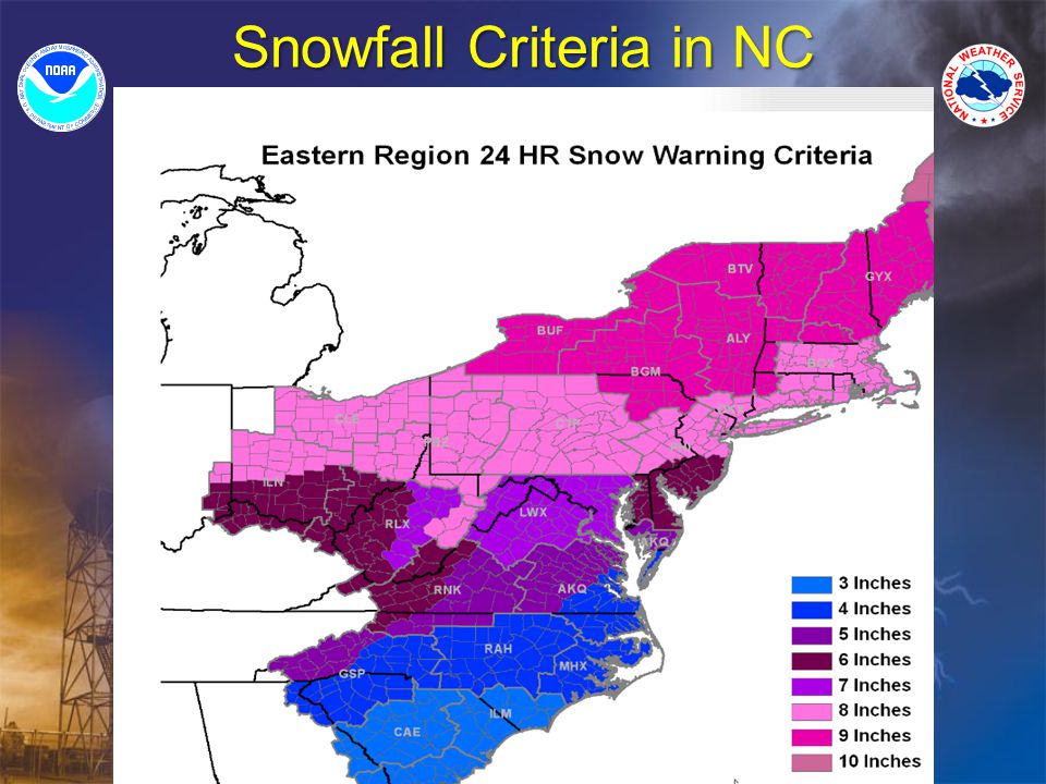
Snowfall Criteria in NC

26
www.weather.gov
27
weather.gov

28
weather.gov

29
weather.gov

30
weather.gov/blacksburg

31
weather.gov How can I determine the forecasters confidence?

32
weather.gov Jan 16, 2008 Forecast Discussion

33
Winter Storm Example 3-7 Days in Advance of The Event

34
Winter Storm Example 3-7 Days in Advance of The Event

35
www.hpc.ncep.noaa.gov

36
www.hpc.ncep.noaa.gov
37
www.hpc.ncep.noaa.gov

38
www.hpc.ncep.noaa.gov

39
www.hpc.ncep.noaa.gov

40
Winter Storm Example Winter Storm Arrives http://www.srh.noaa.gov/ridge2/ridgenew2 /

41
Winter Storm Example Snowfall/Ice Reports

43
Winter Storm Example http://srh.noaa.gov/ridge2/snow/

44
NWSChat https://nwschat.weather.gov Provides EM, media, SKYWARN and other partners to exchange information with NWS forecasters anytime.Provides EM, media, SKYWARN and other partners to exchange information with NWS forecasters anytime. Already integrated within NWS operations.Already integrated within NWS operations. Can run on any PC as well mobile devices such as a Blackberry or Droid.Can run on any PC as well mobile devices such as a Blackberry or Droid.

46
Links provided to all products seconds within issuance including warnings

47
Weather on the Go! NC-First mobile app http://mobile.weather.gov/ https://inws.wrh.noaa.gov

48
https://inws.wrh.noaa.gov
49
NOAA Weather Radio Why Not Have A Tornado Siren In Your Home, Work, or Car? Receive weather information 24 hours a day.Receive weather information 24 hours a day. Radio will sound a tone to alert you when a watch/warning has been issued.Radio will sound a tone to alert you when a watch/warning has been issued. Countless times, lives have been saved by NOAA All- Hazards Weather RadioCountless times, lives have been saved by NOAA All- Hazards Weather Radio NOAAs National Weather Service

50
Thank You!

51
Presentation Outline Introduction (Tony) Introduction (Tony) Climatology and geographic influences (Nick) Climatology and geographic influences (Nick) Winter season products and services (Phil) Winter season products and services (Phil) Outlook for this upcoming winter season (Tony) Outlook for this upcoming winter season (Tony)
 Introduction (Tony) Climatology and geographic influences (Nick) Climatology and geographic influences (Nick) Winter season products and services (Phil) Winter season products and services (Phil) Outlook for this upcoming winter season (Tony) Outlook for this upcoming winter season (Tony)")
64
Outlook for 2012-13 Winter The National Weather Service uses the latest technology and does exhaustive research to determine long-range forecast conditions

67
Whats a few inches of snow to you?

68
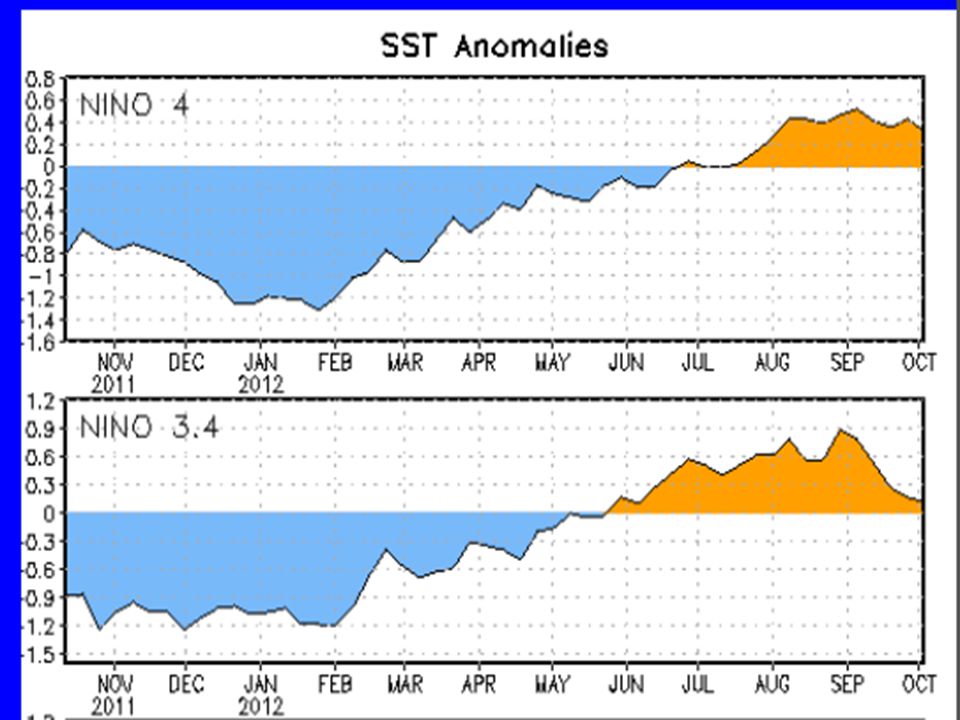
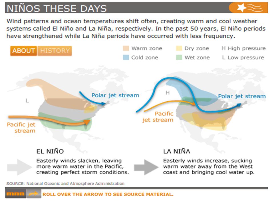
Changes in the Wintertime Atmospheric Flow Related to El Nino More west-to-east flow of jet stream winds than normal across the United StatesMore west-to-east flow of jet stream winds than normal across the United States An eastward extension of the jet stream winds from the International Date Line to the southwest United StatesAn eastward extension of the jet stream winds from the International Date Line to the southwest United States A southward shift of the storm track from the northern to the southern part of the United StatesA southward shift of the storm track from the northern to the southern part of the United States This shift results in an exceptionally stormy winter and increased precipitation across California and the southern U.S. and less stormy conditions across the northern part of the country.This shift results in an exceptionally stormy winter and increased precipitation across California and the southern U.S. and less stormy conditions across the northern part of the country.

69
The Upshot Overall a greater number of opportunities for low pressure systems tracking nearby (Southeast Conus) compared to last winter.Overall a greater number of opportunities for low pressure systems tracking nearby (Southeast Conus) compared to last winter. Will we cash in? The amount of precipitation we receive will be modulated by whether the southern low pressure systems move across the deep south and out to sea, or make a turn up the East Coast or through the Carolinas!Will we cash in? The amount of precipitation we receive will be modulated by whether the southern low pressure systems move across the deep south and out to sea, or make a turn up the East Coast or through the Carolinas! If we cash in, what will be the outcome? Temperatures are the wildcard in this pattern! Usually cold air is locked north because of the jet stream configuration. Therefore our analysis would be for a greater potential for messy mixtures, based on the long range temperature probabilities. However weather history has shown us that the entire spectrum of precipitation types are in play during El Nino Episodes: 1969-70; 1976-77; 2004-2005.If we cash in, what will be the outcome? Temperatures are the wildcard in this pattern! Usually cold air is locked north because of the jet stream configuration. Therefore our analysis would be for a greater potential for messy mixtures, based on the long range temperature probabilities. However weather history has shown us that the entire spectrum of precipitation types are in play during El Nino Episodes: 1969-70; 1976-77; 2004-2005. Note, it is not uncommon to jump temporarily out of these types of regimes for a week or two, and then revert back into the overall El Nino Episode.Note, it is not uncommon to jump temporarily out of these types of regimes for a week or two, and then revert back into the overall El Nino Episode.

70
Questions? Contact information: Nick Petro, WCM Raleigh Nick Petro, WCM Raleigh Nicholas.Petro@noaa.gov Nicholas.Petro@noaa.gov Phil Hysell, WCM Blacksburg Phil Hysell, WCM Blacksburg Phil.Hysell@noaa.gov Phil.Hysell@noaa.gov Tony Sturey, WCM Greenville/Spartanburg Tony Sturey, WCM Greenville/Spartanburg Anthony.Sturey@noaa.gov Anthony.Sturey@noaa.gov

Similar presentations