Download presentation
Presentation is loading. Please wait.

1
Applying Management Frameworks: Experiences from CONSCIENCE sites across Europe Prof A. Sánchez-Arcilla, Prof. J.A. Jiménez, & the CONSCIENCE WP6 team

2
To test the applicability of the management concepts and models developed within the project (the CONSCIENCE approach). The field sites are selected to represent the most common European coastal types: sand and gravel/shingle coasts; high-energy open coasts (Atlantic coasts), medium-energy coasts (North Sea coasts, English Channel coasts) and low-energy coasts (Mediterranean, Baltic Sea and Black Sea) OBJECTIVES
, medium-energy coasts (North Sea coasts, English Channel coasts) and low-energy coasts (Mediterranean, Baltic Sea and Black Sea) OBJECTIVES.")
3
CONSCIENCE Coastal Sites (6) 1. Dutch coast, NL (North Sea). 2. Hel Peninsula, PO (Baltic Sea). 3. Danube delta stretch, RO (Black Sea). 4. Costa Brava Bays, ES (Mediterranean Sea). 5. Pevensey Bay, UK (English Channel). 6. Inch Beach, IR (Atlantic Ocean).
. 3. Danube delta stretch, RO (Black Sea). 4. Costa Brava Bays, ES (Mediterranean Sea). 5. Pevensey Bay, UK (English Channel). 6. Inch Beach, IR (Atlantic Ocean)..")
5
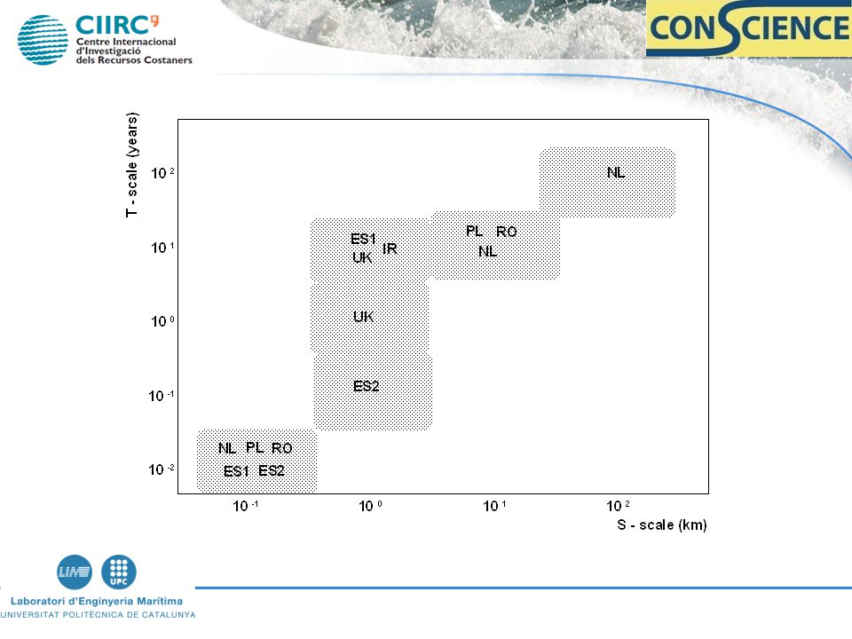
Pentagonal Approach Specific – Site – dependent Measurable – Based on data Applicable – Local stake- holders Realistic – Available Info Means/Tools, Laws, Adm. Time – dependent (t/scales) A SMART FRAME OF REFERENCE
 A SMART FRAME OF REFERENCE.")
6
Pentagonal Approach Sediment Cell Favourable Sediment Status : - No deficit - Natural deficit Resilience - Restore Sed. Balance (Artificial Nourishment) - Reduce intesity of drivers (Coastal Works) - Space for coastal processes (Re-alignement) Strategic sediment Reservoirs Selecting t/s scales Based on 5 concepts
 - Reduce intesity of drivers (Coastal Works) - Space for coastal processes (Re-alignement) Strategic sediment Reservoirs Selecting t/s scales Based on 5 concepts.")
7
Frame of Reference What is the problem Objective How big is it: C.S Indicators (from Reference State Desired State) When action is needed Thresholds What action Catalogue + Concepts How does it work Monitoring Based on 5 questions
 When action is needed Thresholds What action Catalogue + Concepts How does it work Monitoring Based on 5 questions")
9
Location, scale The Dutch coast and its three regions.

10
Long.term resilience coastal foundation 3 sub cells of coastal foundation Netherlands CZ Country Safety

11
3 different scales in coastal management in the Netherlands. Each scale associated with a specific coastal cell and benchmarking of a specific tactical objective: Temporal scale:Spatial scale: - Residual strength days meters - Basal Coast Line (BCL)years kilometers - Coastal foundationdecades / centuries 10s / 100s kilometers
years kilometers - Coastal foundationdecades / centuries 10s / 100s kilometers.")
12
Frame-of-Reference for coastal erosion management in the Netherlands. Question marks indicate issues that are still open for decision making.

13
Danube Delta in Black Sea. The dotted rectangle indicates the coastal cell (CONSCIENCE Pilot Site). Location, scale

14
Sediment transport paths with CERC and wave conditions from SWAN and wind fields

15
Proposal for strategic sediment reservoirs: 1)sediments blocked by the jetties in the Musura Bay and 2)sediments dredged from the channel and discharged off the littoral system
sediments blocked by the jetties in the Musura Bay and 2)sediments dredged from the channel and discharged off the littoral system")
16
Lloret de Mar SAbanell Location, scale

17
0 ~ 30,000 m 3 /y

18
Problem: Damage of Infrastructures Objective: Enhance safety of infrastructures

19
Problem: Affectation of beach use Objective: Maintain recreational carrying capacity

20
FAVOURABLE SEDIMENT STATUS WINTER (stormy period) – Protecting infrastructures: Volume of sediment required to generate a beach wider than the one to be eroded by storms (Tr to be selected ). SUMMER (calm period) – Recreational carrying capacity: Volume of sediment required to generate a beach wide enough to accomodate users (~ 30 m ).
 – Recreational carrying capacity: Volume of sediment required to generate a beach wide enough to accomodate users (~ 30 m )..")
21
~ 0

22
Problem: Damage of Infrastructures Objective: Enhance safety of infrastructures

24
FAVOURABLE SEDIMENT STATUS WINTER (stormy period) – Protecting infrastructures: Volume of sediment properly distributed along the beach in such a way that the beach is wider than the reach associated to storm impacts (Tr to be selected ). SUMMER (calm period) – Recreational carrying capacity: Volume of sediment properly distributed along the beach in such a way that the beach is wider than a minimum recreational width (~ 30 m ).
 – Recreational carrying capacity: Volume of sediment properly distributed along the beach in such a way that the beach is wider than a minimum recreational width (~ 30 m )..")
26
Danube Delta (Romania) Hel-Peninsula (Poland) Pevensy (England) NetherlandsLloret-Blanes (Spain) Erosion Rates (~) (m/yr) 1051Artificially Reduced 1 (var.in space) Sed. Deficit (~) (10 6 m 3 /yr) 10.1 – 0.60.026 (90 – 00) 12 (00 – 10) 0 (Ll) 0.03 (Bl) L – scale (km) 5035104002 Favourable Sed. Status Natural Budget Natural Budget Maint. Thresh. (volume, width) only last 1 yr Maintain 90 state Maintain beach width / volume Present Actions Dredging and disposal outside CZ Artificial Nourishment (since 1989) Annual Nourish. Reshaping (plan/profile) Period. Nourishm. Excp. hard works Re-shaping Nourishment Reinf. Seawall S l Transport Rates (x10 3 m 3 /yr) 1.50070 Sl CERC ~ 10xSlKamph (Sl CERC more realistic) 15 – 30 Groyne Reduction 1/5 Formulae Under-predict Based on observed changes 30 Main Processes Breaching Overwash Roll-back FloodingBeach Oscillat. River mth. losses
 (10 6 m 3 /yr) 10.1 – (90 – 00) 12 (00 – 10) 0 (Ll) 0.03 (Bl) L – scale (km) Favourable Sed. Status Natural Budget Natural Budget Maint. Thresh. (volume, width) only last 1 yr Maintain 90 state Maintain beach width / volume Present Actions Dredging and disposal outside CZ Artificial Nourishment (since 1989) Annual Nourish. Reshaping (plan/profile) Period. Nourishm. Excp. hard works Re-shaping Nourishment Reinf. Seawall S l Transport Rates (x10 3 m 3 /yr) Sl CERC ~ 10xSlKamph (Sl CERC more realistic) 15 – 30 Groyne Reduction 1/5 Formulae Under-predict Based on observed changes 30 Main Processes Breaching Overwash Roll-back FloodingBeach Oscillat. River mth. losses.")
27
Danube Dlta (Romania) Hel-Penins. (Poland) Pevensy (England) NetherlandsC. Brava (Spain) Strategic Objective (+ preserving CZ) Sust. Development ResilienceSustainable Risk ( ~ 400 yrs for breach.) Flooding Risk ( up to 4.000 yr) Sustainable functions (protection, recreation) Operational Objective Reduce Erosion Avoid Breach. Maintain Width Hold the lineMaintain 90 shore (Dune) + Coastal Found. (-20m) Maintain Beach width Proposed Solution Nourishment - From River Mouth (1/2 deficit) - No from spit Nourishmt. -Increase width Nourishment -Increase width Reduce Sl with works Nourishment - Increase space - Increasing Vol. with t Nourishment Re-shaping (plan /profile) Reduce Sl at S bound. Strategic Sediment Reservoirs 2 identified - Bay - River Mouth 3 identified - Harbour entrance - Bays - Offshore 2 identified - Licensed offshore areas 1 identified - Dutch Continental Shelf (> - 20m) 1 identified - River Mouth
 Strategic Objective (+ preserving CZ) Sust. Development ResilienceSustainable Risk ( ~ 400 yrs for breach.) Flooding Risk ( up to yr) Sustainable functions (protection, recreation) Operational Objective Reduce Erosion Avoid Breach. Maintain Width Hold the lineMaintain 90 shore (Dune) + Coastal Found. (-20m) Maintain Beach width Proposed Solution Nourishment - From River Mouth (1/2 deficit) - No from spit Nourishmt. -Increase width Nourishment -Increase width Reduce Sl with works Nourishment - Increase space - Increasing Vol. with t Nourishment Re-shaping (plan /profile) Reduce Sl at S bound. Strategic Sediment Reservoirs 2 identified - Bay - River Mouth 3 identified - Harbour entrance - Bays - Offshore 2 identified - Licensed offshore areas 1 identified - Dutch Continental Shelf (> - 20m) 1 identified - River Mouth.")
28
Danube Δ (Romania) Hel-Peninsula (Poland) Pevensy (England) NetherlandsC. Brava (Spain) CSISl Erosion Rates Beach width /height Dune width /height - Beach width/volum - 5m contour position (from 2000) - Dune Vol. - Coastline (from 1990) - Coastal Foundation Volume - Beach width - Berm height Knowl. Required GenericLong-Term data series Uncertainties - Drivers (RSLR now 2.8 mm/yr, 15mm/yr in 2100) - Responses (Sl reduct. groynes) - Integration of episodic, mid and long-term scales - Inner shelf processes (Coastal Foundation) - Cell barriers (total or partial) - Torrential river input (with submarine canyon) - Joint probability of storm impact for a given configuration
 CSISl Erosion Rates Beach width /height Dune width /height - Beach width/volum - 5m contour position (from 2000) - Dune Vol. - Coastline (from 1990) - Coastal Foundation Volume - Beach width - Berm height Knowl. Required GenericLong-Term data series Uncertainties - Drivers (RSLR now 2.8 mm/yr, 15mm/yr in 2100) - Responses (Sl reduct. groynes) - Integration of episodic, mid and long-term scales - Inner shelf processes (Coastal Foundation) - Cell barriers (total or partial) - Torrential river input (with submarine canyon) - Joint probability of storm impact for a given configuration.")
29
CONCLUSIONS The CONSCIENCE approach has been verified at different T- and S- scales and for coasts subjected to different processes and problems. The frame- of- reference is an useful way to approach to managing coastal erosion (provided strategy is defined). It is possible to define the favourable sediment status for any coast once governing processes are known and objectives are defined (e.g. different status depending on the beach function and scales).
. It is possible to define the favourable sediment status for any coast once governing processes are known and objectives are defined (e.g. different status depending on the beach function and scales)..")
30
CONSCIENCE papers to be published as an Special Issue of O & C M Editorial Paper 1. The Conscience framework Paper 2. NL case study Paper 3. PL case study Paper 4. RO case study Paper 5. UK case study Paper 6. IR case study Paper 7. ES case study Paper 8. Set-back lines Paper 9. Erosion science for coastal management Paper 9. Managing erosion. The Conscience approach

Similar presentations


 tectonics active passive sea-level change may vary widely causes global (eustatic) from +6m to -125.>")

>")


