Download presentation
Presentation is loading. Please wait.

1
Five Places in New Yorks Hurricane Alley Association of American Geographers Spatial Thinking and Hurricanes – Module 8

2
Five places near the shore in Staten Island. What do the numbers on the contour lines indicate ?

3
This is the Verrazano Narrows Bridge in New York City.

4
A long beach extends south of the Bridge.

5
The city built this structure. What do you think it is?

6
How would you describe the construction of the boardwalk?

7
Do you know what these tall grass-like plants are?

8
Place A Elevation 7 Feet

9
How would you describe these houses near Place A?

10
What is different about these new houses?

11
Compare and contrast these two buildings.

12
Why would people build a house 12 steps above the ground?

13
Place B Elevation 10 Feet

14
How would you describe this house near Place B?

15
Why would people build a house above its garage?

16
Place C Elevation 15 Feet

17
Place C is just above the storm-surge danger zone.

18
Describe these apartments between Place C and the ocean.

19
What happens to the land northwest of Place C?

20
How is this house different from the ones near Place A?

21
Place D Elevation 20 Feet

22
How would you describe this house near place D?

23
Place E Elevation 40 Feet

24
How would you describe these apartments near Place E?

25
Describe the land and houses north of Place E.

26
Why did they build a fort on the hillside near Place E?

27
Conclusions Do people live close to the ocean near the Verrazano Narrows Bridge? Is this area vulnerable to a hurricane storm surge? What have people in this area done to protect themselves from storm surges?

28
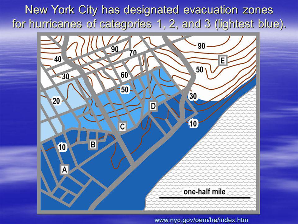
New York City has designated evacuation zones for hurricanes of categories 1, 2, and 3 (lightest blue). www.nyc.gov/oem/he/index.htm
29
Problem: some houses in the storm-surge area are low and vulnerable. What is a fair thing to do about them?

30
Is it fair to require every new house to be built high enough (and strong enough) to be safe from a storm surge?
 to be safe from a storm surge")
31
While we are looking at this house, here is another question – what will a 100-mph wind do to all these overhead wires?

Similar presentations


 Wind: 74-95 miles per hour (mph) Storm Surge: 4-5.>")
![[The Hurricane] Grant Kenney, Jelani P.. Hurricane A Hurricane is a tropical storm that has consistently had speeds over 74mph. The eye of the storm is.](/14/4434350/big_thumb.jpg "[The Hurricane] Grant Kenney, Jelani P.. Hurricane A Hurricane is a tropical storm that has consistently had speeds over 74mph. The eye of the storm is.>")


 sailing Very Dangerous...>")


