Download presentation
Presentation is loading. Please wait.

1
What is topography? the detailed mapping or charting of the features of a relatively small area, district, or locality. the detailed description, especially by means of surveying, of particular localities, as cities, towns, or estates. the relief features or surface configuration of an area. the features, relations, or configuration of a structural entity.

2
Topographical Maps

3
Rules of Contour Lines A contour line represents a single equal elevation: that is, all points on the same contour line have the same elevation. The contour interval is the difference between the values of the two lines.

4
Using Contour Intervals to Construct Maps

8
Rules of Contour Lines Where one closed contour line surrounds another, the inner contour line represents the higher elevation.

11
Rules of Contour Lines The elevation represented by a contour line is always a simple multiple of the contour interval.

12
Rules of Contour Lines A contour line that closes within the limits of the map indicates a hill, ridge or plateau.

13
Rules of Contour Lines Commonly, every fifth contour line (index contour) is darker and its elevation is shown.
 is darker and its elevation is shown.")
14
Rules of Contour Lines On the same map, closely spaced contour lines indicate a relatively steep slope, widely spaced contour lines indicate a relatively gentle slope, and uniformly spaced contour lines indicate a uniform slope.

15
Rules of Contour Lines Contour lines do not cross other contour lines. Exception: on a vertical cliff or a nearly vertical cliff, contour lines touch because they are on top of one another

16
The Palisades

17
Niagara Falls

18
Rules of Contour Lines Every contour line eventually closes against itself. However, the map area may not be large enough to show this closure. Therefore, the contours will end at the edge of the map.

19
Rules of Contour Lines Closed depressions are shown by hachured contour lines. The hachures point into the depression. (Hachures = short dashes)
.")
20
Rules of Contour Lines A hachured contour line, lying between two different contour lines, is the same elevation as the lower contour line.

21
Rules of Contour Lines Where two adjacent contours indicate opposite slopes (hachured contour next to plain contour), both are the SAME elevation.
, both are the SAME elevation.")
22
Rules of Contour Lines Where a contour line crosses a stream or valley, the contour bends to form a “V” that points upstream or up the valley.

23
Symbols used in topo maps

24
Gradient The rate of change of a field value (any measurement) is called a gradient. The gradient (slope) is the rate of change of a field quantity between two places:
 is the rate of change of a field quantity between two places:.")
25
Example The elevation of Pine Hill is 1500 feet above sea level. The elevation of Shokan is 700 feet. The trip down the Esopus Creek is 22 miles. Calculate the gradient (in ft/mile) between Pine Hill and Shokan.
 between Pine Hill and Shokan..")
28
Calculate the gradient between points X and Y. Label your answer with the correct units.

29
Campers hiked along the trail from the shoreline of the lake to point D to view the landscape. Determine the average gradient, in meters per kilometer, of the route they took on their hike.

30
Calculate the gradient along the reference line from A to B, in meters per kilometer. Draw the 60 and 70 m contour lines.

31
Calculate the gradient between locations A and B. Finish the 600, 700, and 800 contour lines that are missing.

32
Profiles A topographic map shows the top view of a surface. To visualize an area, you can make a side view – a profile. Take a strip of paper, place it between two points, and mark wherever the paper crosses a contour line.

33
Draw the profile of CB

34
On the grid below, construct a topographic profile of the land surface along the line from point B to point C. Plot the elevation of each contour line that crosses line BC. Connect all nine plots with a line to complete the profile.

35
On the grid below, construct a topographic profile along line BC. Plot the elevation of each contour line that crosses line BC. Connect all seven plots with a line to complete the profile.

36
On the grid below, construct a topographic profile along line CD by plotting the elevation of each contour line that crosses line CD. Connect all the plots with a line to complete the profile.

37
On the grid below, draw a profile of the bottom of western Lake Ontario by plotting the depth of the water along line AB. Plot each point where an isoline showing depth is crossed by line AB. Connect the plots with a line, starting at A and ending at B, to complete the profile.

38
Contour Map Practice What the gradient from the top of Eagle Hill to Lake Muhl? Draw a profile of line AB. What is the flow direction of the two streams?

39
Draw a line between point C and point L. Make a profile.

40
Mt. St. Helens: Before and After

41
Lab 6: Using Topographical Maps

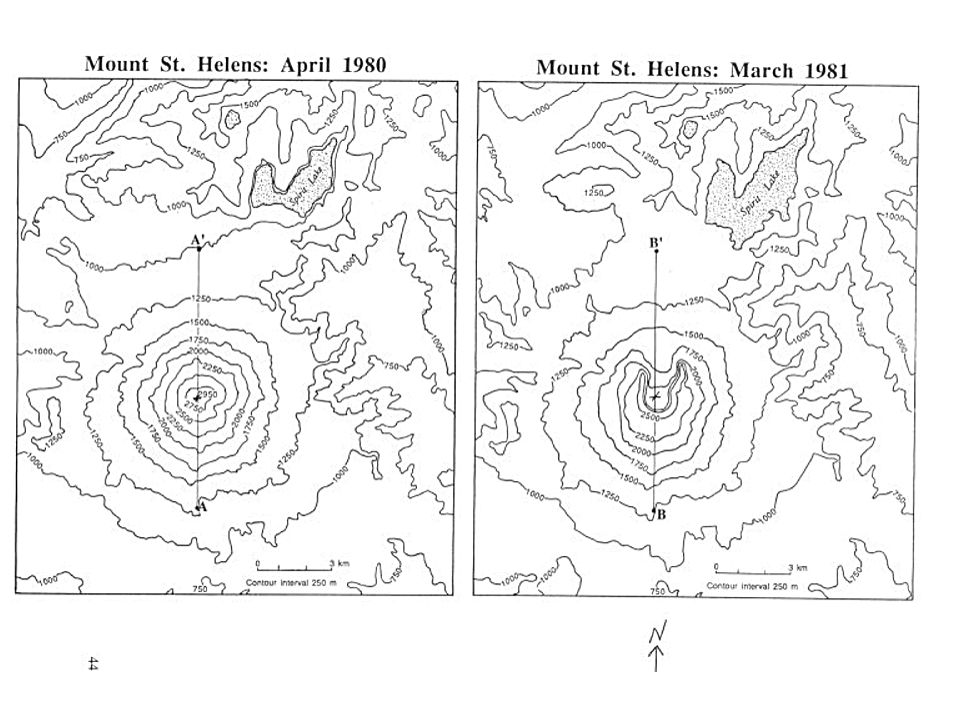
44
Compare these two maps of Mt. St. Helens. Describe four ways they are similar or different from each other. What is the total change in elevation on the “before” map (highest contour-lowest contour)? Now do the same for the “after” map. Calculate the total distance across each map using the scale ____________________
. Now do the same for the after map. Calculate the total distance across each map using the scale ____________________.")
45
Making Profiles of the Volcano Draw a line bisecting the volcano on the bottom map. Try for close to the same location in each. On a separate sheet of graph paper, draw a profile for your line from one end to the other, labeling the features. Do it for both before and after maps.

46
Mt. St. Helens is located at latitude 46.20 N longitude, 122.18 W latitude. It is a stratovolcano, with steep sides. Find the approximate location of the volcano on the map below, and mark it. Find the latitude and longitude of cities listed below.

48
What is the total change in elevation on the “before” map (highest contour-lowest contour)? What is the total change in elevation on the “after” map? Calculate the total distance across the map using the scale. Draw a line bisecting the volcano in both pictures. Try for close to the same location in each. On a separate sheet of graph paper, draw a profile for your line from one end to the other, labeling the features. Do it for both before and after pictures.

49
Part 2 Finding your home on a USGS Map Search for the USGS map that contains your neighborhood. Estimate your longitude and latitude: What is the contour interval of your map? What is the title of your map?

50
What does the numerical scale mean? Draw a line below that represents 1.5 miles on the map. Where is the steepest area on the map? (Give a compass direction from the center of the map). How do you know that this is the steepest area on the map?
. How do you know that this is the steepest area on the map .")
51
Determine the gradient of the steepest hill over a one mile distance. Show your work. What is an indicator on a contour map that allows you to determine the direction of flow of a stream? Using graph paper, create a profile of a 2 mile section that runs through where you live.

52
Bearsville Quadrangle What is the approximate elevation of Cooper Lake? In what direction would you walk from Woodstock to Bearsville? In what direction does the Beaverkill flow in Mink Hollow? What type of road(s) would you travel on to get from School #1 to Silver Hollow? Does the Saw Kill flow into Cooper Lake? How can you tell?
 would you travel on to get from School #1 to Silver Hollow. Does the Saw Kill flow into Cooper Lake. How can you tell .")
53
Bearsville Quadrangle What is the approximate elevation of Mt. Tobais? The quarry near Montoma lies between which two index contours? What is the gradient from the tower on Tonshi Mountain to the house approximately ½ mile north? Show your work below. If you travelled approximately 3500’ along the road from School #4 and turned south, what topographic features would you find? What will the altitude of Polaris be in the hamlet of Woodstock?

54
Woodstock Quadrangle Which side of Plattekill Mountain is the steepest? How do you know? What is the elevation of School #14 near High Woods? In which direction does the Plattekill Creek flow? What is the gradient between the benchmark near Chestnut Hill Cemetery and the top of Overlook Mountain? What is the elevation of “The Green” in Woodstock?

55
Woodstock Quadrangle What is the name and elevation of the highest point on the map? Just south of Highwoods is a swamp with two streams (SE). How do they differ from each other (Check out contour lines) What is the shortest distance driving only on heavy and medium roads between “The Green” and Zena School? What is the gradient between the top of Platekill Mountain and the benchmark just South of West Saugerties? For how many miles would you be ascending (going uphill) if you drove from the Highwoods School towards Kingston Reservoir #1?
. How do they differ from each other (Check out contour lines) What is the shortest distance driving only on heavy and medium roads between The Green and Zena School. What is the gradient between the top of Platekill Mountain and the benchmark just South of West Saugerties. For how many miles would you be ascending (going uphill) if you drove from the Highwoods School towards Kingston Reservoir #1 .")
56
West Shokan Quadrangle What is the elevation of Hanover Mountain? In which direction does the Beaverdam Creek flow? Which side of High Point is the steepest? What is the gradient between the benchmark just NW of Kanape Brook and the top of Little Rocky? What is the distance between Breath Hill and High Point?

57
West Shokan Quadrangle What is the elevation of the last house encountered travelling SW on Peekamoose Road? What is the Name and Elevation of the highest point on the map? What type of stream is South Hallow Brook and how does it differ from other streams? How long is it along High Point Mountain Road from Burgher Road South to the edge of the map? What is the gradient between the intersection of High Point Mountain Road and Broadhead Road and the top of High Point?

58
Phoenicia Quadrangle What is the altitude of Polaris in Mt. Tremper? The Pantherkill flows in what general direction on this quadrangle? What is the gradient of the ski lift west of Phoenicia? Show work. Which is higher in elevation, Cornell or Wittenberg Mountain? What is the elevation of the Onteora Central Campus?

59
Phoenicia Quadrangle How many feet does the Esopus Creek have to rise in order to flood our school? What is the approximate longitude of Woodland Valley? What type of road would you travel to go from Woodland Valley up into Cross Mountain Hollow? The town line between Woodstock and Shandaken runs in what general direction? How many feet in elevation would you have to climb from the campground south of Phoenicia (Uncle Pete’s) to the tower on Tremper Mountain?
 to the tower on Tremper Mountain .")
60
Ashokan Quadrangle What is the elevation of the Ashokan Reservoir? Determine the highest points on both sides of the reservoir. Estimate the latitude and longitude of these locations. Determine the gradient from the highest point on the Shokan side of the reservoir to the intersection of Route 28 and Reservoir Rd.

61
Ashokan Quadrangle Compare the topography of both sides of the reservoir. Explain the direction of streams on the Shokan side of the reservoir in terms of their common topographical features. Why is it more difficult to find these features on the Marbletown side?

62
Ashokan Quadrangle How wide is the reservoir at it’s widest point? At its narrowest? Estimate the area of Kenosia Lake, in square feet. A train passes a benchmark as it passes over reservoir road heading northeast. What is the gradient to the next benchmark?

Similar presentations


 Isolines NEVER touch.>")


 of the Earth’s surface.>")


>")


