Download presentation
Presentation is loading. Please wait.

1
NWCG Geospatial Sub Committee GISS Webinar Tuesday May 3, 2016 3:00 PM Eastern 2:00 PM Central 1:00 PM Mountain 12:00 Noon Pacific 11:00 AM Alaska National Wildfire Coordinating Group (NWCG) Geospatial Subcommittee (GSC) http://www.nwcg.gov/committees/geospatial-subcommittee
 Geospatial Subcommittee (GSC)")
2
Today’s Presenters Emmor Nile, OR (State) Andrew Bailey, DOI WFM-RD&A Sean Triplett, USFS Lorri Peltz-Lewis, USFS Kathie Hansen, NPS Elizabeth Lile, USGS Tom Mellin, USFS
 Andrew Bailey, DOI WFM-RD&A Sean Triplett, USFS Lorri Peltz-Lewis, USFS Kathie Hansen, NPS Elizabeth Lile, USGS Tom Mellin, USFS")
3
Objective: To inform wildland fire incident GIS resource people about the status of topics impacting the 2016 fire season. Overview: Sponsored by Geospatial Sub Committee (GSC) Questions submitted via email or Webinar chat One hour in length Qualified GISS and GISS-T invited Situation unit leaders invited Webinar recording to be posted at gis.nwcg.gov
 Questions submitted via or Webinar chat One hour in length Qualified GISS and GISS-T invited Situation unit leaders invited Webinar recording to be posted at gis.nwcg.gov.")
6
Federal ArcGIS version status 10.X USFS – ArcGIS 10.3.1 NPS – ArcGIS 10.3/10.3.1 FWS – ArcGIS 10.3.1 (mostly) BLM – ArcGIS 10.3.1 Tribes & BIA – ArcGIS 10.3/10.3.1
 BLM – ArcGIS Tribes & BIA – ArcGIS 10.3/10.3.1")
7
States’ ArcGIS Status 10.3.1 – AL, FL, GA, KY, LA, MS, NC, OR, RI, TX, VA, WA 10.2 – AK, AR, AZ, CA, CO, CT, DE, KS, MA, MI, MN, NE, NM, NV, NY, OK, PA, SD, TN 10.1 – ID, MD, ME, MT, NH, OH, SC, UT, WV 10.0 –HI, MO, WI Unknown – IA, IL, IN, ND, VT, WY

8
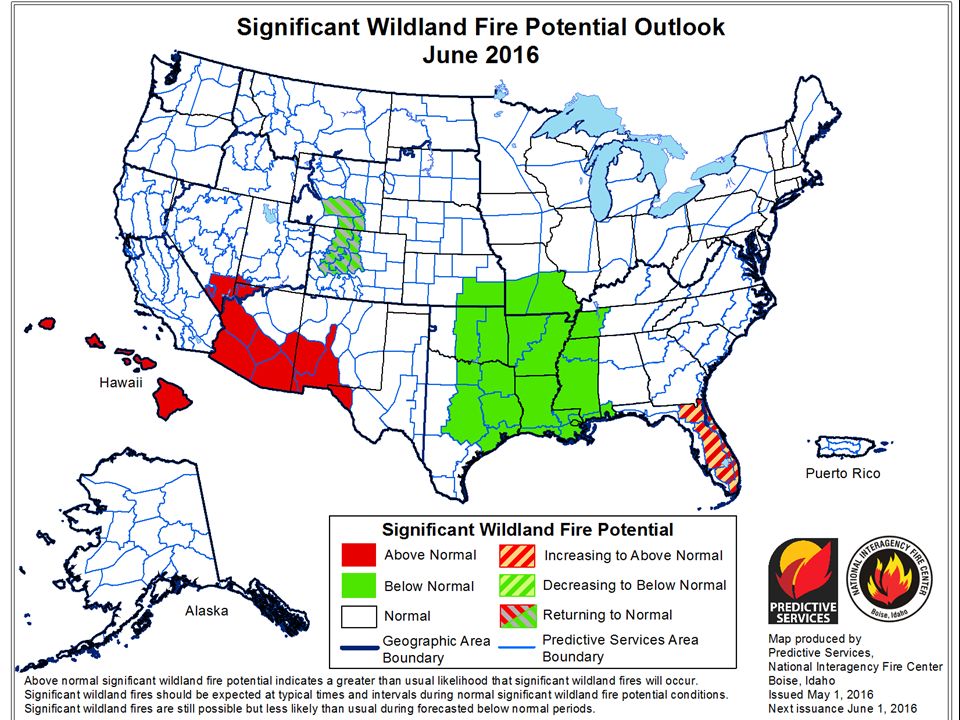
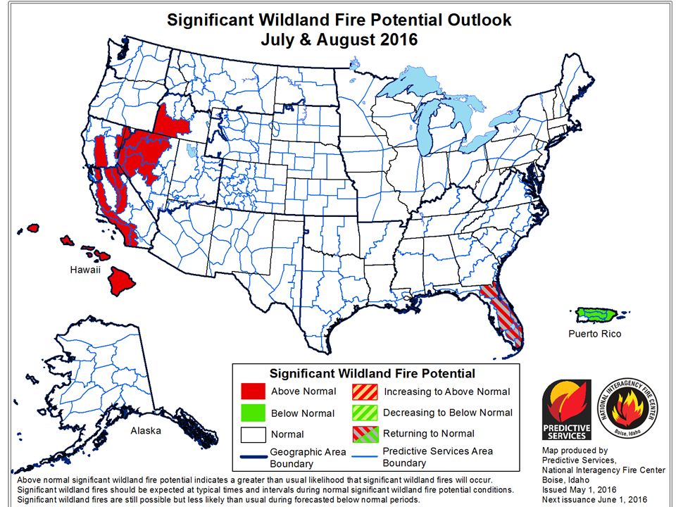
ArcGIS in 2016 Poll

10
Maps and data can be posted and accessed via a QR Code or Avenza

11
http://egp.nwcg.gov NIFC Fire Enterprise Geospatial Portal (EGP) Integration with AGOL and Collector o Desktop/Laptop, Collector, & AGOL GeoPDF Creation & Export BLM Lightning (Past 72 Hours) AFF / ATU Data feeds Progression (Animation) with Perimeters Extract Perimeters based on user inputs Public Version Inciweb Integration New HTML 5 / JAVA Script Interface Resources Available vs Resources Committed ESRI 3D API Globe that replaces Google Earth.
 Integration with AGOL and Collector o Desktop/Laptop, Collector, & AGOL GeoPDF Creation & Export BLM Lightning (Past 72 Hours) AFF / ATU Data feeds Progression (Animation) with Perimeters Extract Perimeters based on user inputs Public Version Inciweb Integration New HTML 5 / JAVA Script Interface Resources Available vs Resources Committed ESRI 3D API Globe that replaces Google Earth.")
12
FGX Limited Release Coming in early summer 2016 Includes: Collector & EGP upload Fire Incident Mapping Tool Version 10.0.11

13
ArcGIS Online (AGOL) & Collector (IMT Pilot) http://nifc.maps.arcgis.com
 & Collector (IMT Pilot)")
14
Upload FIMT GDB View / Manage IMT Pilot Create FIMT GDB http://gis.nwcg.gov/links_tools.html EGP Tools to support FIMT & IMT Pilot

15
S-341 GIS Specialist for Incident Management Courses sponsored by GTU

16
2015 GIS Specialist Summary from ROSS QUALIFIEDTRAINEE 2015 GISS Sum of days by qualification 7,098 2,703 Count # of individuals with assignment 253 132 ROSS available # 465 581 Percentage of individuals54%23%

17
2015 ROSS Status of GIS Specialists DOI & USDA = 4.4% net attrition = +/- 44 new GISS or GISS(T) needed per year
 needed per year")
18
2016 GISS Trainee preparation Availability in ROSS GACC Priority Trainee list Be Proactive, make contacts & network Volunteer locally to get experience Prescribed fire Search & Rescue Other ICS incidents

19
GIS STandard Operating Procedures on Incidents PMS 936, September 2014 publication http://www.nwcg.gov/pms/pubs/gstop.pdf 2016 CHANGE Medivac removed Unimproved Landing Area added

20
GSTOP Key Points! “... met by all NWCG participating agencies.” Ch. 2 (data mgmt.), Ch. 5 (symbology), and Ch. 6 (maps) Ch. 7: fire perimeter and fireline layers shared on a daily basis Post data on a the NIFC ftp site, ftp://ftp.nifc.gov ftp://ftp.nifc.gov Many applications and sites depend on this: www.geomac.gov, http://inciweb.nwcg.gov/ www.geomac.govhttp://inciweb.nwcg.gov/
, Ch. 5 (symbology), and Ch. 6 (maps) Ch. 7: fire perimeter and fireline layers shared on a daily basis Post data on a the NIFC ftp site, ftp://ftp.nifc.gov ftp://ftp.nifc.gov Many applications and sites depend on this:")
21
GPS & Mobile Technology on Incidents GSC web site, http://gis.nwcg.gov http://gis.nwcg.gov Garmin Online Training, GPS for Fire Mgmt. Operations & ICS course materials & Tools (2013) Mobile Technology in Fire & Aviation Avenza – USFS enterprise license, DOI - ask AGOL & Collector http://nifc.maps.arcgis.com http://nifc.maps.arcgis.com http://www.wildfirelessons.net
 Mobile Technology in Fire & Aviation Avenza – USFS enterprise license, DOI - ask AGOL & Collector")
22
GIS Licenses – All Hazard Support GIS Licenses supporting All Hazards response: GISS Advanced ArcGIS – for single installs - single use, authenticates to Esri, includes all Category A extensions (Spatial Analyst, 3D Analyst, etc), 2015/2016 expires April 2016 GISS-L Advanced ArcGIS – for server installs – concurrent use, 10 licenses, requires license manager install, authenticates to Esri, includes all Category A extensions (see above) - 2015/2016 expires April 2016 Licenses for 2016/2017 request submitted, delivery requested 3/15/2016 Need a license? Contact – Lorri Peltz-Lewis, USFS R5, California lpeltzlewis@fs.fed.uslpeltzlewis@fs.fed.us 916-995-3107

23
Technology Rentals GIS Contracts for 2016/2017: Hartford (CA) – includes: Computers, Plotter, Printers, etc. SmartSource (National) – includes: Computers, Printers, etc. GISS Computer: Win7 (64-bit), Intel i7, 16 GB RAM, 1280x960 resolution, Ethernet/WiFi/Bluetooth, etc. GISS Software: ArcGIS 10.3.1, 10 licenses, FIMT, DNR GPS, xTools, Google Earth, etc. Fire Rentals have the GISS-L license installed (10 concurrent) Hartford and SmartSource –image under development –to vendors 4/1/16 GIS software not working contact Lorri ASAP. Ordering tip sheet is available at http://gis.nwcg.gov/http://gis.nwcg.gov/ Full list of specifications available – lpeltzlewis@fs.fed.uslpeltzlewis@fs.fed.us
 – includes: Computers, Printers, etc. GISS Computer: Win7 (64-bit), Intel i7, 16 GB RAM, 1280x960 resolution, Ethernet/WiFi/Bluetooth, etc. GISS Software: ArcGIS , 10 licenses, FIMT, DNR GPS, xTools, Google Earth, etc. Fire Rentals have the GISS-L license installed (10 concurrent) Hartford and SmartSource –image under development –to vendors 4/1/16 GIS software not working contact Lorri ASAP. Ordering tip sheet is available at Full list of specifications available –")
24
GEOMAC - USGS Comments, questions? geomac@usgs.govgeomac@usgs.gov

25
REST Services http://wildfire.cr.usgs.gov/ArcGIS/rest/services/ Dynamic KML Downloads http://rmgsc.cr.usgs.gov/outgoing/GeoMAC/current_year_fire_data/

26
http://nirops.fs.fed.us/

27
GISS & WFDSS Typical requests: Create maps of fire behavior outputs for planning and operations meetings Add Management Action Points (MAPs) to GISS products such as Situation Unit or Operations Maps Primary Users: FBAN / LTAN / GSAN SOPL Local/Host Unit Staff Agency Administrators Download perimeters & KMZ data packages for “groups” of incidents in WFDSS Auto-grouping of fires in complexes
 to GISS products such as Situation Unit or Operations Maps Primary Users: FBAN / LTAN / GSAN SOPL Local/Host Unit Staff Agency Administrators Download perimeters & KMZ data packages for groups of incidents in WFDSS Auto-grouping of fires in complexes")
28
NWCG Data Standards Updates: http://www.nwcg.gov/data-standards Data exchange standards for data exchange between agencies and between systems Approved: Wildland Fire Perimeters (polygon) – 2014 Wildland Fire Locations (point) – 2014 Fuels Treatments (polygon) – 2014 Aviation Hazards – 2015 Activity (point, polygon) Obstacle (point, line, polygon) Proposed: Wildland Fire Event (2015) Assigned: Aviation Hazards (revision) Infrared Spatial Data Elements Assigned (continued) Resource Location Water Sources Protection Unit (polygon) Predictive Service Area Boundary (polygon) Fire Management Unit Helispot GACC Boundary Wildfire Dispatch Area Boundary Wildfire Dispatch Office Location Mitigation Plan Boundary Wildland Urban Interface (polygon)
 – 2014 Wildland Fire Locations (point) – 2014 Fuels Treatments (polygon) – 2014 Aviation Hazards – 2015 Activity (point, polygon) Obstacle (point, line, polygon) Proposed: Wildland Fire Event (2015) Assigned: Aviation Hazards (revision) Infrared Spatial Data Elements Assigned (continued) Resource Location Water Sources Protection Unit (polygon) Predictive Service Area Boundary (polygon) Fire Management Unit Helispot GACC Boundary Wildfire Dispatch Area Boundary Wildfire Dispatch Office Location Mitigation Plan Boundary Wildland Urban Interface (polygon)")
29
How To Stay Informed

30
Webinar URL List: NWCG Geospatial Subcommittee (GSC), http://www.nwcg.gov/committees/geospatial-subcommittee FIMT, http://gacc.nifc.gov/rmcc/fire_incident/index.htmlhttp://gacc.nifc.gov/rmcc/fire_incident/index.html FIMT training, http://training.nwcg.gov/courses/UsingFIMT/player.htmlhttp://training.nwcg.gov/courses/UsingFIMT/player.html GPS training, http://gis.nwcg.gov/training_gps.htmlhttp://gis.nwcg.gov/training_gps.html GSTOP 2014, http://www.nwcg.gov/sites/default/files/products/gstop_0.pdf http://www.nwcg.gov/sites/default/files/products/gstop_0.pdf Incident GIS Support services (NIFC FTP), http://ftp.nifc.govhttp://ftp.nifc.gov Inciweb, http://inciweb.nwcg.gov/ http://inciweb.nwcg.gov/ NWCG Data Standards, http://www.nwcg.gov/data-standards Wildland Fire Decision Support System (WFDSS), http://wfdss.usgs.govhttp://wfdss.usgs.gov GEOMAC, http://www.geomac.govhttp://www.geomac.gov GEOMAC REST Services, http://wildfire.cr.usgs.gov/ArcGIS/rest/services/http://wildfire.cr.usgs.gov/ArcGIS/rest/services/ S-341 Training (GISS), http://www.odf.state.or.us/gis/gtu/g2.htmlhttp://www.odf.state.or.us/gis/gtu/g2.html National Infrared Operations, http://nirops.fs.fed.us/http://nirops.fs.fed.us/ Wildfire Lessons Learned Center, http://www.wildfirelessons.nethttp://www.wildfirelessons.net Questions received via email and webinar chat
, FIMT, FIMT training, GPS training, GSTOP 2014, Incident GIS Support services (NIFC FTP), Inciweb, NWCG Data Standards, Wildland Fire Decision Support System (WFDSS), GEOMAC, GEOMAC REST Services, S-341 Training (GISS), National Infrared Operations, Wildfire Lessons Learned Center, Questions received via and webinar chat")
31
Membership DOI-OWF – Andrew Bailey, Chair Andrw_Bailey@nps.gov NPS - Dave Hammond Dave_Hammond@nps.gov BIA - Joe Kafka Joseph.Kafka@bia.gov USFS - Jill Kuenzi jkuenzi@fs.fed.us BLM - Dianna Sampson dsampson@blm.gov DOI-OWF - Susan Goodman Susan_Goodman@ios.doi.gov USGS - Liz Lile ellile@usgs.gov FWS - Cameron Tongier Cameron_Tongier@fws.gov Eastern States - Curt Stripling (TX) cstripling@tfs.tamu.edu Western States - Joe Stansbury (NE) jstansberry2@unl.edu
 Western States - Joe Stansbury (NE)")
32
End of webinar Be Safe http://gis.nwcg.gov

Similar presentations


 Required Characteristics & 75% of Key Indicators (8) OH.>")


