Download presentation
Presentation is loading. Please wait.

1
Locus: an Urban Spatial Location Tool Ligiane Souza, Tiago Delboni, Karla Borges, Clodoveu Davis Jr. e Alberto Laender UFMG – Universidade Federal de Minas Gerais Prodabel – Empresa de Informática e Informação do Município de Belo Horizonte

2
Outline Introduction Objective Goals Place Ontology Conceptual Modeling Current Stage Conclusion

3
Introduction Indirect Spatial References: used when the location is not explicitly given, using spatial coordinates Place names Addresses Postal codes Telephone numbers There is the need to geographically locate the reference, i.e., to obtain direct references or coordinates Used also to understand how people refer to spatial places and events, in order to be able to determine the geographic context embedded in the communication

4
Objective To implement a location tool for urban places, admitting as input: (postal) addresses references to places (official, popular, or previous names, postal codes, telephone numbers and others)
 addresses references to places (official, popular, or previous names, postal codes, telephone numbers and others)")
5
Goals To create a gazetteer, based on an ontology of places To develop efficient and intelligent methods for searching and navigating using the gazetteer To make results available for usage through the Web

6
Ontology of Places (1) This work is based on the definition of an ontology of places:
 This work is based on the definition of an ontology of places:")
7
Ontology of Places (2)
")
8
Conceptual Modeling using OMT-G (1) From the ontology, a conceptual schema was created for the gazetteer
 From the ontology, a conceptual schema was created for the gazetteer")
9
OMT-G Conceptual Modeling (2)
")
10
OMT-G Conceptual Modeling (3)
")
11
System Architecture Matcher Resultado Interface de consulta BuscaNavegação Consulta Espacial Monta contexto GazetteerOntologia Navega Desempate

12
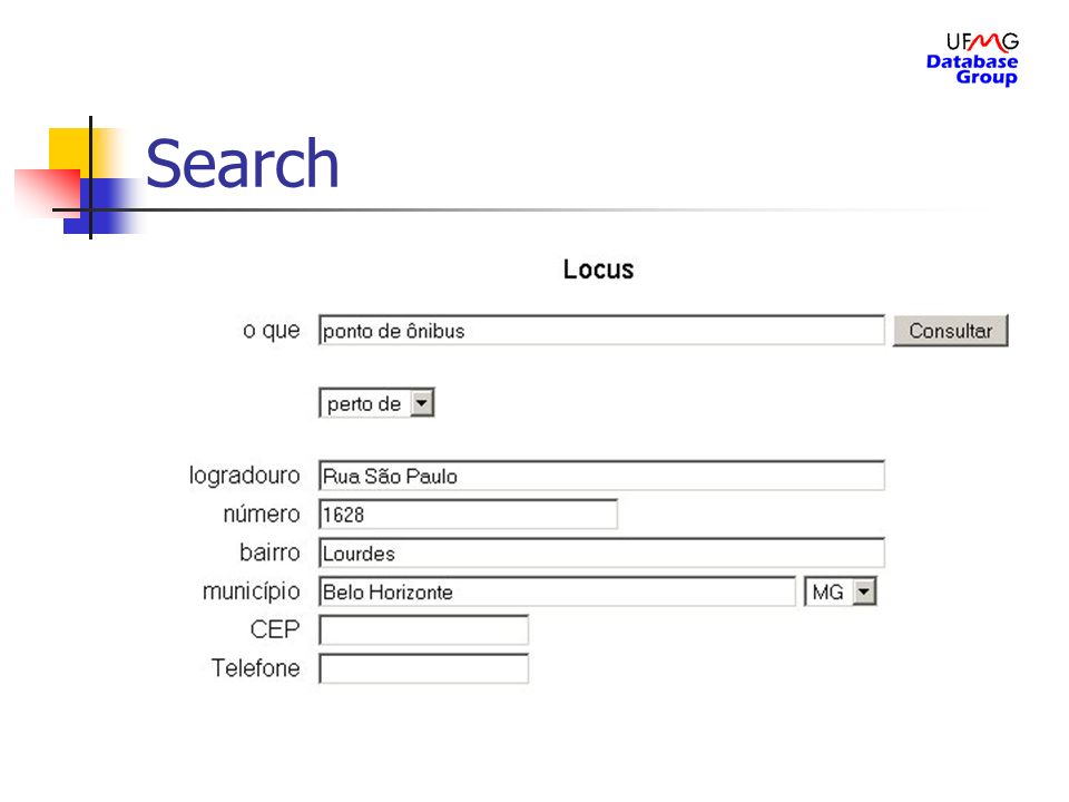
Search Point of interest Spatial relation expression Point of reference

13
Search

15
Result

16
Result with spatial relation

17
Implementation Web interface developed using JSP PostGIS DBMS MapServer

18
Current stage Available data: Political and administrative divisions of Brazil down to the municipal level Postal codes of all major cities down to the individual thoroughfares Telephone area codes down to the prefix level Poits of reference with exclusive postal code Individual addresses and reference points of the city of Belo Horizonte The current development stage is focused on the name matching routines

19
Conclusions LOCUS will allow the location and visualization of places of interest Through the ontology it is possible to implement an intuitive mechanism for user navigation The tool has the potential to be employed in any application in which the location of events and objects through indirect referencing is necessary, such as: Public health records Public safety Education Urban planning Identification of the geographic contect from the text in Web pages

Similar presentations