Download presentation
Presentation is loading. Please wait.

1
CalNex Forecast Prepared Saturday 5 June 2010

2
Anticipated Platform Activities NOAA P3 Sat: No Flight Sun: resume day flights (likely target SJV) NOAA Twin Otter Sat: morning flight in LA Basin; afternoon flight in LA, Mojave, & southern SJV Sun: afternoon flight in LA, Mojave, & southern SJV Mon: similar flights as Sat with more emphasis likely in southern SJV Tue: No Flight Wed: transit to Sacramento, sampling Central Valley Thu - Mon: No Flights - maintenance R/V Atlantis Sat: 5 Jun: Martinez Sun: 6 Jun: transit to offshore DOE G-1 & NASA B-200 (CARES - http://campaign.arm.gov/cares)http://campaign.arm.gov/cares Sat: No G-1 Flight; B-200 possibly Sun: morning and afternoon flights Mon: possible morning and afternoon flights
 NOAA Twin Otter Sat: morning flight in LA Basin; afternoon flight in LA, Mojave, & southern SJV Sun: afternoon flight in LA, Mojave, & southern SJV Mon: similar flights as Sat with more emphasis likely in southern SJV Tue: No Flight Wed: transit to Sacramento, sampling Central Valley Thu - Mon: No Flights - maintenance R/V Atlantis Sat: 5 Jun: Martinez Sun: 6 Jun: transit to offshore DOE G-1 & NASA B-200 (CARES - Sat: No G-1 Flight; B-200 possibly Sun: morning and afternoon flights Mon: possible morning and afternoon flights")
3
Local Features Sat: SoCal: O3 increasing (USG to unhealthy in east LA basin) Sun: Sac: Sac plume to east, skirting south of receptor site; moderate air quality SJV: good to moderate air quality - poorer air quality in southern portion of SJV SoCal: tracer model of LA pollution indicates strongest early morning offshore push of weekend; O3 air quality anticipated to be USG or higher in eastern LA basin; LA plume to desert (more east (Banning) than north (Cajon)) Mon: Sac: Sac plume toward receptor site; moderate air quality SJV: good to moderate air quality - poorer air quality in southern portion of SJV; SoCal: LA plume to desert (more east (Banning) than north (Cajon) Tue: SJV: descending air with high O3 over southern SJV Wed: if flight range permits, TO flight to Sac could look for O3 along west side of SJV and coastal ridge line Recommendations: Sunday flight track(s) include LA plume in bight in morning and in desert in afternoon; Monday flight: Sac plume looks promising for CARES Tuesday flight(s): southern SJV may have high O3 in descending air mass
 Sun: Sac: Sac plume to east, skirting south of receptor site; moderate air quality SJV: good to moderate air quality - poorer air quality in southern portion of SJV SoCal: tracer model of LA pollution indicates strongest early morning offshore push of weekend; O3 air quality anticipated to be USG or higher in eastern LA basin; LA plume to desert (more east (Banning) than north (Cajon)) Mon: Sac: Sac plume toward receptor site; moderate air quality SJV: good to moderate air quality - poorer air quality in southern portion of SJV; SoCal: LA plume to desert (more east (Banning) than north (Cajon) Tue: SJV: descending air with high O3 over southern SJV Wed: if flight range permits, TO flight to Sac could look for O3 along west side of SJV and coastal ridge line Recommendations: Sunday flight track(s) include LA plume in bight in morning and in desert in afternoon; Monday flight: Sac plume looks promising for CARES Tuesday flight(s): southern SJV may have high O3 in descending air mass")
4
Synoptic Overview for California Saturday June 5 Zonal flow north, ridge south Offshore gradients south, weak onshore north Shallow marine layer in the south Sunday June 6 Ridge is pushed S/E by another PacNW trough Onshore flow increases for the north Offshore grads continue in the south Monday June 7 Zonal flow pushes farther south as ridge shifts east Onshore flow resumes in the south, continues in the north Tuesday-Friday Ridge tries to rebound Tuesday Trough pushes south out of PacNW for Wed Trough digs south Thurs/Fri

5
Analysis GFS – 00 Z Saturday – Fri 17 PDT

6
12 hour GFS – 12 Z Saturday – 05 PDT

7
24 hour GFS – 00 Z Sunday – Sat 17 PDT

8
36 hour GFS – 12 Z Sunday – 05 PDT

9
48 hour GFS – 00 Z Monday – Sun 17 PDT

10
60 hour GFS – 12 Z Monday – 05 PDT

11
GFS 3 day – 00 Z Tuesday – Mon 17 PDT

12
ECMWF 3 day – 00 Z Tuesday – Mon 17 PDT

13
3.5 day GFS – 12 Z Tuesday – 05 PDT

14
4 day GFS – 00 Z Wednesday – Tue 17 PDT

15
4 day ECMWF – 00 Z Wednesday – Tue 17 PDT

16
5 day GFS – 00 Z Thursday – Wed 17 PDT

17
5 day ECMWF – 00 Z Thursday – Wed 17 PDT

18
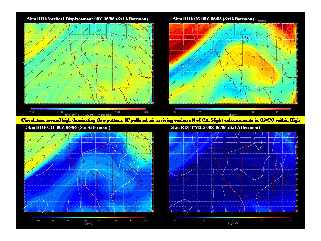
Large Scale Transport RAQMS FX updated Sat, Jun 05th

27
SF Bay Area NO FORECAST TODAY

39
http://sfports.wr.usgs.gov/cgi-bin/wind/windbin.cgi

40
Sacramento Valley NWS Forecast Saturday: MOIST WESTERLY FLOW CONTINUES OVER NORCAL WITH WEAK QUASISTATIONARY BAROCLINIC ZONE DRAPED ACROSS THE NORTHERN INTERIOR. A FEW LIGHT SHOWERS CONTINUE ACROSS SHASTA COUNTY IN VICINITY OF WEAK FRONT. FARTHER SOUTH...INCREASING SUBSIDENCE AS DESERT SOUTHWEST RIDGING SLOWLY BUILDS NORTHWARD WILL RESULT IN MOSTLY SUNNY SKIES WITH WARMING TEMPERATURES. VALLEY HIGHS TODAY EXPECTED FROM THE LOWER 80S IN THE NORTHERN SACRAMENTO VALLEY TO THE LOWER 90S IN THE NORTHERN SAN JOAQUIN VALLEY. WITH A PW PLUME OF 200 PERCENT ABOVE NORMAL OVER THE AREA TODAY...DEWPOINTS IN THE UPPER 50S TO LOW 60S WILL RESULT IN A SOMEWHAT HUMID DAY BY NORCAL STANDARDS. Sunday: SHORT WAVE APPROACHING 40N 140W WILL LIFT ACROSS THE FAR NORTHERN INTERIOR TONIGHT INTO SUNDAY KEEPING A SLIGHT CHANCE OF SHOWERS FOR SHASTA COUNTY...MAINLY MOUNTAINS. REMAINDER OF CWA EXPECTED TO CONTINUE TO WARM SUNDAY AS 850 MB TEMPS INCREASE A COUPLE DEGREES. DOWNTOWN SACRAMENTO EXPECTED TO BE NEAR 90 SUNDAY. SUBSIDENCE WITH DESERT SOUTHWEST RIDGING WILL SHALLOW DEPTH OF MARINE LAYER AND THUS DIMINISH COOLING OF DELTA BREEZE WHICH MAY DEVELOP WITH THE TROF ROTATING INTO THE PAC NW SUN.

41
Sacramento Valley (cont'd) Mon & Tues: LITTLE CHANGE IN SYNOPTIC PATTERN MONDAY INTO TUESDAY AS NORCAL REMAINS BETWEEN LONG WAVE TROUGH IN THE PACIFIC AND HIGH PRESSURE OVER THE DESERT SOUTHWEST. SIGNIFICANTLY DECREASING PWS OVER THE AREA MONDAY/TUESDAY WILL RESULT IN DRIER ONSHORE FLOW WITH MORE SUNSHINE FOR THE NORTHERN INTERIOR ALONG WITH SLIGHTLY WARMER TEMPS. MONDAY EXPECTED TO BE WARMEST DAY OF THE WEEK WITH VALLEY HIGHS NEAR 90 WITH GENERALLY 70S TO 80S FOR THE MOUNTAINS. Wed - Fri: MEDIUM RANGE MODELS PROG NEXT SIGNIFICANT SHORT WAVE INTO THE PAC NW WEDNESDAY WITH DEEPENING TROUGH OVER NORCAL INTO THURSDAY. SYNOPTIC COOLING OVER THE AREA WITH INCREASED ONSHORE FLOW WILL COOL VALLEY TEMPS BACK INTO THE 70S FOR THE MOST PART BY THURSDAY. MODELS DIFFER ON TIMING WITH ECMWF SLOWER THAN PREFERRED GFS/GEM WHICH SUGGEST A SLIGHT CHANCE OF POPS FOR THE NORTHERN MOUNTAINS AND SIERRA NEVADA WEDNESDAY NIGHT INTO THURSDAY. DRIER NORTHERLY FLOW EXPECTED TO DEVELOP OVER THE AREA FRIDAY AS UPSTREAM RIDGING APPROACHES THE WEST COAST.

42
San Joaquin Valley Saturday June 5 Surface Winds: Surface obs this morning: Light to moderate NW flow across most of the SJV. SSW to S wind at Porterville this morning. Temperatures in the 60s and clear skies. The wind profilers show a moderate to strong N to NW flow above the surface across the SJV. CANSAC shows light to moderate NW flow over Delta, Altamont and Pacheco Passes late morning becoming N flow in afternoon and W flow by 23:00. Outflow over the passes throughout the day and night. Light to moderate NW flow on valley floor throughout the day except in Kern County when light S flow develops in evening. Upslope flow in the afternoon stops after sunset with weak flow after. Boundary Layer Mixing: CANSAC shows that mixing will improve from 3,000 to 5,000 feet with best heights over Kern, Tulare, south Fresno Counties and San Joaquin County. NWS Hanford forecasts clear skies over SJV. Air Quality: Good to moderate air quality due to ozone. Moderate AQ possible in southern SJV. Sunday June 6 Surface Winds: CANSAC shows early morning moderate W flow through Delta then flow splits becoming light flow northward into Sac County and remaining moderate flow into San Joaquin County. Early morning W flow over the Passes into SJV. W Flow strenghtens by afternoon and evening into Sac and San Joaquin Counties and over Passes. Light to moderate NW flow on valley floor through the day, lightest winds in Kern and Tulare Counties. Light S flow on east side of valley in morning and after sunset. Upslope flow begins late morning and weakens again after sunset. Outflow over passes throughout the day and night. NWS Hanford forecasts clear skies over SJV. Boundary Layer Mixing: CANSAC shows that mixing will improve from 3,000 to 5,000 feet with best heights over Kern, Tulare, Fresno Counties. Air Quality: Good to moderate AQ due to ozone. Moderate AQ possible in southern SJV.

43
San Joaquin Valley (cont'd) Monday June 7 Surface Winds: CANSAC shows light W flow through the Delta splitting with part of the flow turning northward into Sac County and part remaining W into San Joaquin throughout the day; flow becomes moderate by 17:00. Moderate NW on valley floor weakens as day progresses. Light SW flow in Kern County during morning. Weak N flow develops over Cottonwood Pass at 2:00. Outflow over passes throughout the rest of the day. Boundary Layer Mixing: CANSAC shows that mixing will improve from 3,000 to 5,000 feet with best heights Tulare and Fresno Counties. NWS Hanford forecasts clear skies over SJV. Air Quality: Good to moderate air quality due to ozone. Moderate AQ possible in southern SJV. Tuesday and Wednesday June 8-9 Surface Winds: GFS shows NW flow over SJV on Tuesday and SW flow over SJV on Wednesday. Boundary Layer Mixing: Best heights expected to improve to 3,000 to 5,000 feet. NWS Hanford forecasts clear skies over SJV both days. Air Quality: Good to moderate AQ expected due to ozone. *Potential Targets for next Flight Day* Kern County will be the best target due to possibility of moderate AQ due to ozone. Also, a weakening flow over crest of Pacheco Pass could be an interesting feature to observe during day on Sunday.

44
Central Coast NO FORECAST TODAY

45
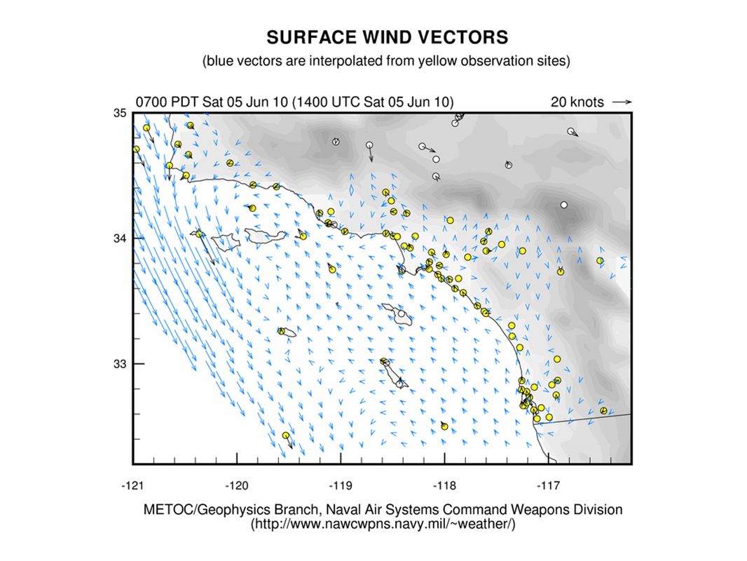
Southern Coastal Waters

48
10m Winds eddy offshore & downslope/offshore flow during night/early morning; onshore days divergence of southerly nearshore flow in late mornings on Sun and Mon as eddy dies

60
Low Level Clouds Sat - Tues: Clouds on north coast and off San Diego; in between, any coastal stratus in central and southern CA burns off Mon & Tues: clouds developing along central coast late Mon & Tues

72
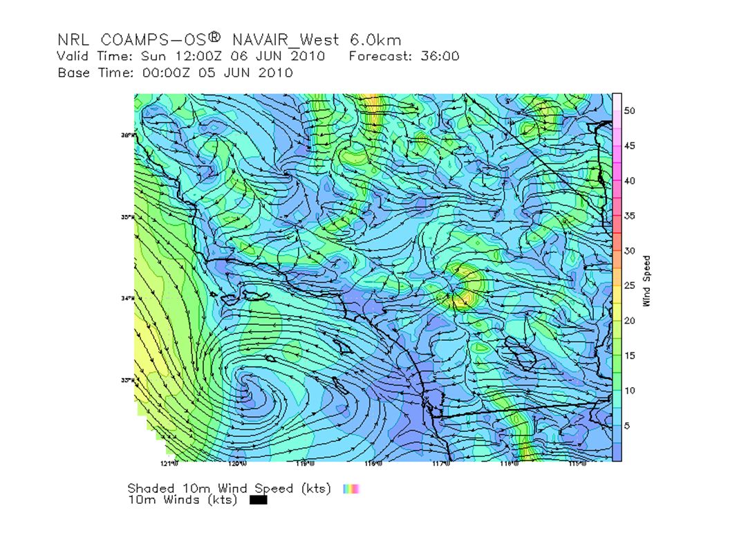
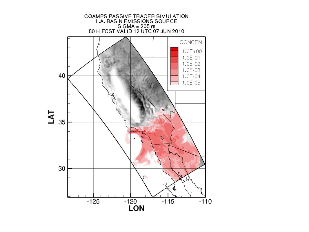
LA plume (205m) offshore flow to bight with basin outflow to desert (more to lower desert than high desert)
 offshore flow to bight with basin outflow to desert (more to lower desert than high desert)")
84
South Coast Saturday: ozone to USG with some Unhealthy possible Crestline & Riverside NWS forecast discussion HIGH PRESSURE WILL CONTINUE TO DOMINATE THE AREA...WARMING TEMPERATURES TO ABOVE NORMAL LEVELS THROUGH THE WEEKEND. GUSTY WINDS WILL CONTINUE IN THE MOUNTAINS AND DESERTS. AS THE HIGH PRESSURE WEAKENS...A COOLING TREND WILL BEGIN ON MONDAY...WITH MOST TEMPERATURES DROPPING BACK BELOW SEASONAL NORMALS BY MIDWEEK. Sat: CURRENTLY AN 800 FOOT MARINE LAYER COVERS ALL THE BEACHES AND IS SLOWLY WORKING ITS WAY INLAND PUSHED ALONG BY A WEAK EDDY. THE VENTURA VLYS SHOULD STAY CLEAR BUT CLOUDS SHOULD REACH THE SAN GABRIEL AND SAN FERNANDO VLYS BY SUNRISE. THE EDDY...ONSHORE FLOW AND VERY STRONG INVERSION WILL COMBINE TO MAKE FOR A SLOW CLEARING DAY ALONG THE BEACHES. BELOW THE INVERSION ACROSS THE COASTS TEMPS WILL BE MILD WITH BEACH MAX TEMPS IN THE MID TO UPPER 60S AND THE INTERIOR COASTAL SECTIONS ONLY IN THE 70S. ABOVE THE INVERSION THE TEMPS WILL SOAR AGAIN WITH MAX TEMPS IN THE MID 80S TO MID 90S. IT WILL BE WINDY AGAIN TODAY ESP IN THE DESERTS AND THE FAR WESTERN PORTIONS OF THE SANTA YNEZ RANGE BUT ONSHORE PUSH IS WEAKER TODAY AND WINDS SHOULD STAY A FEW MPH BELOW ADVISORY CRITERIA.EDDY VLYS EDDYONSHORE FLOW INVERSION TEMPSMAX TEMPSMIDINVERSIONTEMPSMAXTEMPSMID ADVISORY

85
South Coast (cont'd) Sunday: VERY SIMILAR TO TODAY IN ALL ASPECTS...PERHAPS A DEGREE WARMER ALMOST EVERYWHERE. Monday: A COOL DOWN WILL START IN THE VLYS AS THE MARINE LAYER SHOULD LIFT ENOUGH UNDER FALLING HGTS TO MAKE IT INTO THE VLYS. THE COASTAL TEMPS SHOULD BE SIMILAR TO SUNDAY SINCE THE MARINE LAYER WILL BE SIMILAR. THE MTNS AND DESERTS WILL ALSO NOT CHANGE MUCH AS HGTS DO NOT LOWER THAT QUICKLY. Tuesday - Friday: SLOW COOLING TREND WILL CONTINUE TUESDAY AND WEDNESDAY WITH A SLIGHT INCREASE IN MARINE LAYER DEPTH AND PENETRATION ALONG WITH A SLOW LOWERING OF HGTS MAX TEMPS. ON THURSDAY AN UPPER LOW MOVES INTO THE PAC NW AND BRINGS A LARGE TROF OVER THE WEST COAST. THIS TROF WILL LIFT THE MARINE LAYER INTO ALL OF THE VLYS EXCEPT THE SANTA CLARITA. INTERIOR TEMPS WILL DUMP DOWN 5 TO 6 DEGREES WITH COASTAL TEMPS STAYING ABOUT THE SAME AND VLY TEMPS LOWERING ANOTHER 2 TO 4 DEGREES. ANOTHER GOOD MARINE LAYER FRIDAY WILL KEEP THE COASTS AND VLYS ABOUT THE SAME AS THU BUT THE INTERIOR WILL WARM ABOUT 4 DEGREES AS THE TROF MOVES OUT AND HIGHER HGTS BUILD IN.VLYS TEMPSMTNSMAXTEMPSPACNW TROF VLYSTEMPS VLYTEMPSVLYSTROF

86
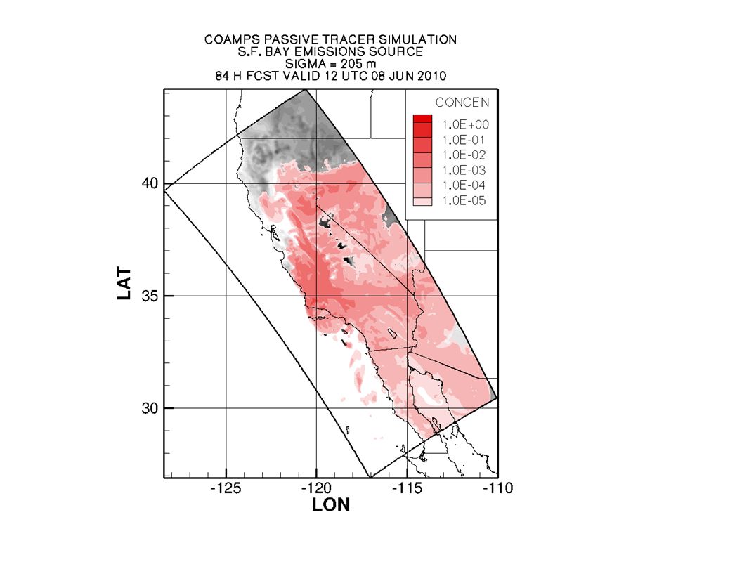
Northern California Observed, Model-Interpolated Winds for SF Bay http://sfports.wr.usgs.gov/cgi-bin/wind/windbin.cgi and COAMPS Wind Plots http://www.sccoos.org/data/coamps/coamps.html

Similar presentations


 Prepared by Jennie Moody (UVA) and Mike Porter (FSU)>")


 …what development was forecast? Lecture 26: Map discussion 12Z Wed (analysis)>")


>")

>")