Download presentation
Presentation is loading. Please wait.

2
Landslides are simply defined as the mass movement of rock, debris or earth, down a slope and have come to include a broad range of motions whereby falling, sliding and flowing under the influence of gravity dislodges earth material. They often take place in conjunction with earthquakes, floods and volcanoes.

4
Landslides occur when the stability of a slope changes from a stable form to an unstable form. groundwater (pore water) pressure acting to destabilize the slope groundwater Loss or absence of vertical vegetative structure, soil nutrients, and soil structure (e.g. after a wildfire - a fire in forests lasting for 3–4 days) soil structure erosion of the toe of a slope by rivers or ocean waves erosionwaves weakening of a slope through saturation by snow melt, glaciers melting, or heavy rainsglaciers
 pressure acting to destabilize the slope groundwater Loss or absence of vertical vegetative structure, soil nutrients, and soil structure (e.g. after a wildfire - a fire in forests lasting for 3–4 days) soil structure erosion of the toe of a slope by rivers or ocean waves erosionwaves weakening of a slope through saturation by snow melt, glaciers melting, or heavy rainsglaciers.")
5
earthquakes adding loads to barely stable slope earthquakes earthquake-caused liquefaction destabilizing slopesliquefactionslopes volcanic eruptions volcanic eruptions deforestation, cultivation and construction, which destabilize the already fragile slopes. deforestationcultivationconstruction vibrations from machinery or traffic vibrationsmachinerytraffic Blasting earthwork which alters the shape of a slope, or which imposes new loads on an existing slope earthwork in shallow soils, the removal of deep-rooted vegetation that binds colluvium to bedrocksoilsrootedvegetation colluviumbedrock Construction, agricultural or forestry activities (logging) which change the amount of water which infiltrates the soil. Constructionlogging
 which change the amount of water which infiltrates the soil. Constructionlogging.")
6
Landslide can be classified as: 1.Debris flow 2.Earth flows 3.Debris slide 4.Sturzstrom 5.Shallow landslide 6.Deep seated landslide

7
Ex: AmbooriEx: Amboori debris flow, occurred on 9 November 2001 in Kerala, India. The event killed 39 people. slope material that becomes saturated with water may develop into a debris flow or mud flow. The resulting slurry of rock and mud may pick up trees, houses and cars, thus blocking bridges and tributaries causing flooding along its pathsaturated debris flowmud flowrocktributaries flooding EarthflowsEarthflows are downslope, viscous flows of saturated, fine-grained materials, which move at any speed from slow to fast. Typically, they can move at speeds from 0.17 to 20 km/h (0.1 to 12.4 mph). Though these are a lot like mudflows, overall they are slower moving and are covered with solid material carried along by flow from within.mudflows
. Though these are a lot like mudflows, overall they are slower moving and are covered with solid material carried along by flow from within.mudflows.")
8
A debris slide is a type of slide characterized by the chaotic movement of rocks soil and debris mixed with water or ice (or both). They are usually triggered by the saturation of thickly vegetated slopes which results in an incoherent mixture of broken timber, smaller vegetation and other debris. A sturzstrom is a rare, poorly understood type of landslide, typically with a long run-out. Often very large, these slides are unusually mobile, flowing very far over a low angle, flat, or even slightly uphill terrain.

9
Landslide in which the sliding surface is located within the soil mantle or weathered bedrock(typically to a depth from few decimetres to some metres)is called a shallow landslide. They usually include debris slides,debris flow, and failures of road cut-slopes. Landslides in which the sliding surface is mostly deeply located below the maximum rooting depth of trees (typically to depths greater than ten meters).
..")
10
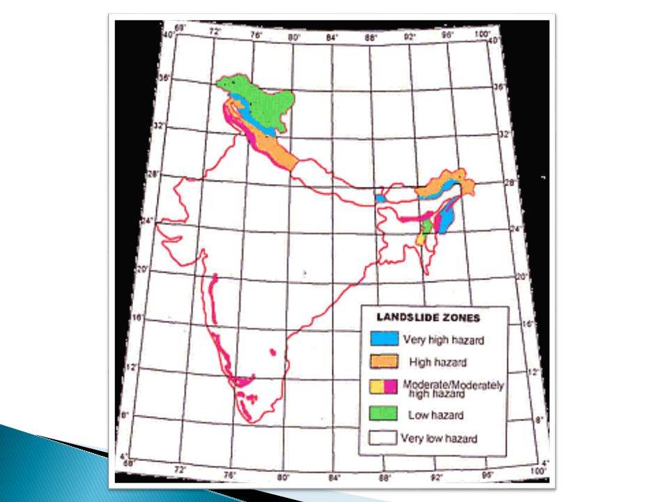
landslide hazard analysis and mapping can provide useful information for catastrophic loss reduction, and assist in the development of guidelines for sustainable land use planning. The analysis is used to identify the factors that are related to landslides, estimate the relative contribution of factors causing slope failures, establish a relation between the factors and landslides, and to predict the landslide hazard in the future based on such a relationship. GIS is an appropriate tool because it has functions of collection, storage, manipulation, display, and analysis of large amounts of spatially referenced data which can be handled fast and effectively. Remote Sensing techniques are also highly employed for landslide hazard assessment and analysis. Before and after aerial photographs and satellite imagery are used to gather landslide characteristics, like distribution and classification, and factors like slope,lithology, and land use/land cover to be used to help predict future events.

11
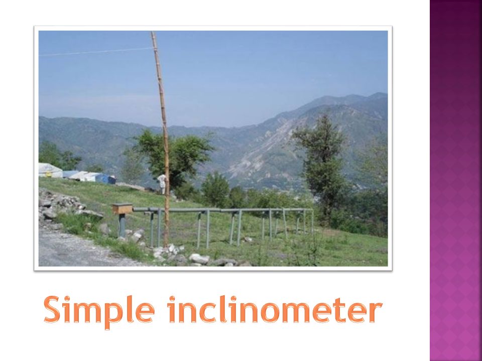
The newly designed warning system for landslide is “ A strain gauge based inclinometer for landslide early warning system”. Earlier expensive liquid/ gas inclinometer were used to measure the bend in the deep earth probe. Modern landslide warning system often deploy expensive liquid/gas inclinometers for accurate bend measurement in deep earth probe(DEP), containing sensor column. The traditional way which the local people generally use to keep themselves aware of these landslide disasters are the development of cracks and fissures in the roads and areas of hilly region.
, containing sensor column. The traditional way which the local people generally use to keep themselves aware of these landslide disasters are the development of cracks and fissures in the roads and areas of hilly region..")
15
1.1969: Tista valley was the scene of catastrophic landslides that damaged large stretches of NH-31 as well as resulted in the washing out of the tista bridge at sevoke. 2.1971: Heavy rainfall triggered extensive landslides in the alaknanda valley. 3.1972-73: severe incidence of landslides in jammu and kashmir areas. 4.1976: Landslides in sikkim and darjeeling areas due to heavy rainfall and consequent floods in the tista valley. 5.1979: extensive landslides along NH-1A in J&K and also on NH-21A in H.P. 6.1983: A major length of NH-17 in the western ghats was damaged by landslides.

16
7.1985: extensive landslides in hilly areas of kerala. 8.1986: landslide problem in J&K area along NH-1A 9.1989: Landslide occurred on shimla highway. 10.1990: Landslide occurred in neelkanth area near Rishikesh. 11.9 nov 2001: Amboori, kerala. Landslide occurred killing 40 people and supposedly the worst landslide in kerala states history. 12. 6 june 2013: Landslide occurred in kedarnath, uttrakhand after floods killing 5700 people or more. 13. 30 july 2014: Landslide occurred in Malin village, Ambegaon Taluka, Pune, MH; killing more than 100 people. The maximum part of the village was covered under the landslide mud and debris.

17
14. 15 August 2014: Landslide occurred in Uttrakhand, after cloud burst killing 24 people. 15. 16 August 2014: Landslide occurred in Dehradoon killing 7 people.

18
MANGEMENT Vegetation Retaining wall Road construction away from prone area Avoid forest fire Deep rooted plantation Drainage channels construction Pitching

19
Thank you

Similar presentations