Download presentation
Presentation is loading. Please wait.

1
Hiding in plain sight Westchester County GIS Helps Identify Potential Farmland 30 Minutes Outside NYC Presented by Lucille Munz Hilltop Hanover Farm – Yorktown Heights, NY

2
When you think of Westchester County, you probably don’t think of it as a place with many farms. However it might surprise you then to know, that according to the Department of Planning the County has 7,547 acres of land certified as “farmland” by the county’s Agriculture & Farmland Protection Board (AFPB). But these farm lands just represent a small percentage (2.6%) of all County land.
. But these farm lands just represent a small percentage (2.6%) of all County land..")
3
Most of the farmland In Westchester is comprised mainly of: Most of these farms currently do not provide much in the way of local food production. But that is changing!

4
Local food or the local food movement is a movement which aims to connect food producers and food consumers in the same geographic region, in order to: develop more self-reliant and resilient food network improve local economies improve access to fresh locally grown food strengthen community and protect the environment The National Restaurant Associations Survey of Top 5 Menu Trends for 2014 Locally source meats and seafood Locally grown produce Environmental sustainability Healthful Kid’s meals Gluten-free cuisine

5
This is awesome!! People enacting positive change by how they consume! We are helping our local economy and the environment by voting with our wallets? Really? This seismic shift in how consumers purchase and eat their food is “ripe” for change and this change, impacts site planning. Nationwide, the demand for locally grown food has coincided with a “fundamental change in the way developers think about the amenities that people like in new home communities,” said Ed McMahon, a senior fellow with the Urban Land Institute. “Agriculture is the new golf.”

6
This is great, let’s implement this forward planning here in Westchester, there is definitely a rising demand for locally grown food in the tristate area. Problems you say? What problems? Lack of access to affordable farm land Lack of farmer training and a coordinated support system

7
Proposed Project solution by: The Friends of Hilltop Hanover Farm is a nonprofit 501(c) (3) whose mission is to develop, strengthen, and inspire an accessible sustainable food system and environmental stewardship to benefit all residents of Westchester County, New York and its neighbors. The Friends of Hilltop Hanover Farm, operates a 60-acre working educational crop farm on County owned land in Yorktown Heights. Implemented through a generous Food Shed Grant from the Westchester Community Foundation to: Enhance the viability of farming in the County by: Identifying potential land agricultural land parcel and owner matches Establishing the groundwork for a new 2-year apprenticeship program Developing a business model for satellite farming and long-range plan for food/farm/hub aggregation site

8
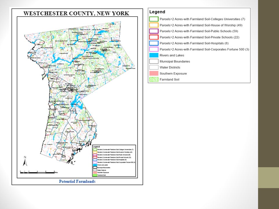
In collaboration with Hilltop Hanover Farm, GIS staff worked to identify potential “farmland” opportunities across the county. This was done as to identify potential future partners in the program, only properties associated with educational, academic, medical, religious institutions, and selected corporate and business parks were included in the initial mapping effort. The criteria developed by Hilltop Hanover staff included variables such as: designated agricultural soils Slopes solar orientation access to water parcels two acres or larger Non-wooded parcels. Enter Westchester County GIS

9
We now have a map that identifies nearly 5,000 acres of potential idle farmland. This allows us to start to pursue potential land/lease agreements to get newly trained farmers working on farmland in the communities they live. The potential exists to have schools provide food to school cafeterias, hospitals with their own “farmers” helping to augment food for their patients and employees, and corporate parks having their own farm stands on- site for the benefit of their employees. With so many site requirements and constraints which were required for our site analysis and potentially so much land to cover, especially on such a broad countywide scale, GIS software was the logical and perfect fit in helping us identify potential small scale farming locations.

10
AGRIBURBIA CONCEPT Agriburbia® is design movement and economic model that advocates for private development and re- development which integrates aspects of Agrarianism, along with contemporary design methods and other environmentally sound principals of real estate development. It combines the positive cultural, physical and financial characteristics from both the urban and rural ends of the land use spectrum to create an entirely new designation. Agriburbia incorporates professional food production as a key element in the community design, social network, and financial viability of the development. Development Supported Agriculture

12
Imagine the possibilities! www.hilltophanoverfarm.org

Similar presentations


 Expansion of leadership and civic engagement to capitalize on innovative strategies >")


