Download presentation
Presentation is loading. Please wait.

1
Barrow Area Spatial Data Infrastructure A collaborative effort of the Barrow Arctic Science Consortium Digital Working Group Funding for this effort has been made possible through cooperative agreements with the Office of Polar Programs at the National Science Foundation and the US Geological Survey. On a global scale, the “Establishment of Spatial Data Infrastructures (SDI) is emerging as a major endeavor. The SDI encompasses the policies, organizational remits, data, technologies, standards, delivery mechanisms and financial and human resources necessary to ensure the availability and access to spatial data.” - Global Spatial Data Infrastructure web site: www.gsdi.org
 is emerging as a major endeavor. The SDI encompasses the policies, organizational remits, data, technologies, standards, delivery mechanisms and financial and human resources necessary to ensure the availability and access to spatial data. - Global Spatial Data Infrastructure web site:")
2
Barrow Arctic Science Consortium Digital Working Group Who are we? Arctic researchers reliant on Information Technology (IT) actively conducting research in the Barrow area What do we do? Advise, coordinate, facilitate and promote: - Information Technology at BASC - Barrow Area Spatial Data Infrastructure - Development of the Barrow Area Information Database (BAID) - Linkages to local, regional and external interest groups such As the Barrow High School, NSB GIS facility, NSIDC, ALIAS, University research community, etc.
 actively conducting research in the Barrow area What do we do. Advise, coordinate, facilitate and promote: - Information Technology at BASC - Barrow Area Spatial Data Infrastructure - Development of the Barrow Area Information Database (BAID) - Linkages to local, regional and external interest groups such As the Barrow High School, NSB GIS facility, NSIDC, ALIAS, University research community, etc..")
3
Barrow Area Spatial Data Infrastructure Hardware, software, DGPS, GIS framework data, remote sensing data acquisition including ground control points, framework data with common standards, data sharing, online data access, user resources, support for wireless mapping technologies, cooperative agreements

4
Barrow Area SDI Data Standards File naming conventions and directory structure Standard file formats: ESRI shape files, GeoTiffs, MrSID, etc. Compression: Winzip ESRI Software: ArcGIS, ArcIMS Data access via ArcIMS and FTP Map Projection and Datum: UTM zone 4, NAD83 Federal Geographic Data Committee (FGDC) Metadata Data archive: National Science Foundation’s Arctic System Science (ARCSS) Data Coordination Center (ADCC) at the National Snow and Ice Data Center
 Metadata Data archive: National Science Foundation’s Arctic System Science (ARCSS) Data Coordination Center (ADCC) at the National Snow and Ice Data Center.")
5
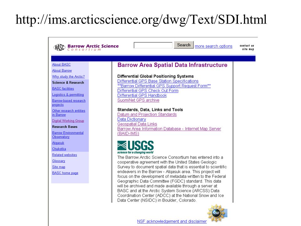
http://ims.arcticscience.org/dwg/Text/SDI.html
6
Barrow, Alaska A Legacy of research Develop a tool for logistical support and planning, as well as, a means to connect researchers

7
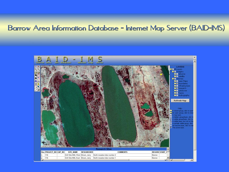
Barrow Area Information Database (BAID)
")
8
Internet address: ims.arcticscience.org Open a folder to view an expanded list of layers and themes that you can view and/or query The scale bar can be changed to read in miles, feet, kilometers and meters. Note coordinates of locations to load as waypoints in your GPS. Interactive toolbar Overview map Help Online Tutorial

9
Future Plans 1. Enhance help files, user guide 2. Provide IMS training for local interest groups 3.Integrate BAID into the permitting process for the new BEO SRD 4.Incorporate more data (record more research site locations, more imagery, infrastructure, coastlines, etc.) 5.Increase application performance (using *.sid, SDE/SQL) 6.Archive Barrow Area spatial data; provide FTP access to data 7. Enhanced Searching capability 8. Use BAID-IMS in the classroom
 5.Increase application performance (using *.sid, SDE/SQL) 6.Archive Barrow Area spatial data; provide FTP access to data 7. Enhanced Searching capability 8. Use BAID-IMS in the classroom.")
Similar presentations


 Multimedia GIS (http://geoinfo.sdsu.edu/mediaGIS)>")


 October 28, 2004 Database Issues.>")

