Download presentation
Presentation is loading. Please wait.

1
U.S. Integrated Ocean Observing System (IOOS ® ) Z Improve safetyEnhance our economyProtect our environment CIMAR-GOMC meeting – 25 Feb 2015 Zdenka Willis Director, US IOOS Office
 Z Improve safetyEnhance our economyProtect our environment CIMAR-GOMC meeting – 25 Feb 2015 Zdenka Willis Director, US IOOS Office.")
2
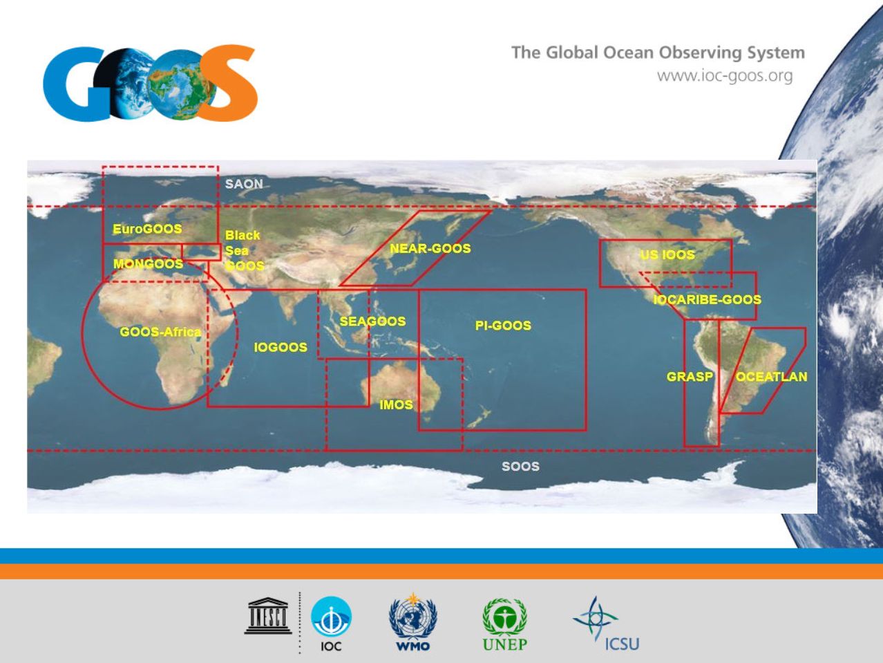
8 5 6 11 2 4 10 3 7 9 1 U.S. IOOS ® : Program Overview Codified in law (P.L. No 111-11, March 2009) Partnership effort that leverages dispersed national investments to deliver ocean, coastal and Great Lakes data relevant to decision- makers 12 Coastal Component –17 Federal agencies –13 regional partners –Academia & Industry Global Component –US contribution to GOOS –64% of the Global Climate Ocean Observing System completed 2
 Partnership effort that leverages dispersed national investments to deliver ocean, coastal and Great Lakes data relevant to decision- makers 12 Coastal Component –17 Federal agencies –13 regional partners –Academia & Industry Global Component –US contribution to GOOS –64% of the Global Climate Ocean Observing System completed 2.")
3
IOOS - National Backbone 607: Buoys, Water Level Gauges, Coastal and Estuary stations PORTS ® Satellites Stream Gauges Water Quality Research Infrastructure 3

4
IOOS – Regional Component 449: Buoys, Water Level Gauges, Coastal and Estuary stations High Frequency Radar Waves Tagging 4

5
IOOS: Advancing Communities HF Radar: Gliders: Animal Telemetry: 5 Wave Measurements:

6
DMAC: Delivering Information http://catalog.ioos.us http://www.ioos.noaa.gov/catalog 6

7
Marine Sensor Innovation Sensor Evaluation Coastal Modeling Test bed Ocean Technology Transition 7

8
A third-party testbed for evaluating technologies P H Sensors (2013/2014) – 7 DO Sensors II (2014/2015) – 10 Nutrient Sensor Challenge (2015/2016) A forum for capacity and consensus building An information clearinghouse for environmental technologies ACT Services Alliance for Coastal Technologies 8
 – 7 DO Sensors II (2014/2015) – 10 Nutrient Sensor Challenge (2015/2016) A forum for capacity and consensus building An information clearinghouse for environmental technologies ACT Services Alliance for Coastal Technologies 8")
9
US IOOS Coastal & Ocean Modeling Testbed Venue to facilitate testing and transitions into operations. Improving ties to different NOAA and partner Agency modeling efforts. 5 projects; Hypoxia in Gulf of Mexico and Chesapeake Bay, Inundation in PR/USVI, West Coast Operational Forecast System, CI tools for comparing models/data 9

10
Ocean Technology Transition – FY13 West Coast Ocean AcidificationPredicting Harmful Algal Blooms Accomplishments –Expanded Gulf of Maine ESPs –Enhanced Reaction & Filter Puck –Model Integration –Data thru NERACOOS 10

11
Ocean Technology Transfer – FY14 11 Fostering the transition of marine sensor and other advanced observing technologies to operations mode. IOOS awarded five grants totaling $2.1 million Operational Nutrient Observatory for the Northeastern United States – Industry Partner: WetLabs Imaging Flow CytoBot in SF Bay – Industry Partner: McLain & Axiom The “Burk-o-lator” – developing low cost OA sensors

12
Marine Biodiversity 3 MBON projects: showing how marine and coastal data can be integrated into the system This U.S. regional contribution to GEO BON Four geographic areas: –the Florida Keys –Monterey Bay –Santa Barbara Channel Islands –U.S. Chukchi Sea http://www.ioos.noaa.gov/biodive rsity/welcome.html 12 Credit: MBARI

13
U.S. IOOS: A System of Systems

15
continuous satellite measurements of sea surface temperature, height, winds, ocean color, and sea ice Total in situ networks 67% Dec 2014 Surface measurements from volunteer ships (VOS) Global drifting surface buoy array Tide gauge network (GLOSS committed) XBT sub-surface temperature section network Argo profiling float network Repeat hydrography and carbon inventory 100% 250 ships in VOSclim pilot project 5° resolution array: 1250 floats 100% 40% 39% 100% 62% 300 real-time reporting gauges 37000 XBTs deployed 3° resolution array: 3200 floats Full ocean survey in 10 years Global tropical moored buoy network 76% 125 moorings planned 87 combined sites Global time series network 66% 3034 4045 485556 59 6062 62% 20002001200220132003200420052006200720082009201020112012 Representative Milestones Original goal for full implementation by 2010 System % sustained, of initial goals 100% ice buoys Fast dataSlow/no data GPS (Planned) 67% 2014
 Global drifting surface buoy array Tide gauge network (GLOSS committed) XBT sub-surface temperature section network Argo profiling float network Repeat hydrography and carbon inventory 100% 250 ships in VOSclim pilot project 5° resolution array: 1250 floats 100% 40% 39% 100% 62% 300 real-time reporting gauges XBTs deployed 3° resolution array: 3200 floats Full ocean survey in 10 years Global tropical moored buoy network 76% 125 moorings planned 87 combined sites Global time series network 66% % Representative Milestones Original goal for full implementation by 2010 System % sustained, of initial goals 100% ice buoys Fast dataSlow/no data GPS (Planned) 67% 2014")
16
22-23.11.2012GEO-IX Plenary, Foz do Iguaçu, Brazil

17
Enables decision making Fosters Advances in Science and Technology www.noaa.ioos.gov https://www.facebook.com/usioosgov @usioosgov US IOOS at Work 17

Similar presentations


 Partnership.>")


 NOAA’s Approach to Build an Initial Operating Capability John H. Dunnigan Assistant Administrator NOAA’s National.>")


 Demonstration Project Ports of Los Angeles/Long Beach Julie Thomas Southern California Coastal Ocean Observing.>")
 A Regional Observing System within the Integrated Ocean Observing System Molly McCammon, Executive Director 1007 W.>")


 NOAA Assistant Administrator for.>")
 2012 Mark Merrifield University of Hawaii Requirements Status Strategies Partnerships Emerging technologies.>")
 We need advanced tools to understand and monitor our oceans, coasts and Great Lakes.>")
 Zdenka Willis Director, US IOOS Program Office Improve safetyEnhance our economyProtect our environment.>")

