Download presentation
Presentation is loading. Please wait.

1
Regional Geology Of Iraq In Relation To The Arabian Plate And Resulting Minerogenesis By Saad Z Jassim Heritage Oil

2
North Arabia Geology Rutba Uplift Rutba Uplift Zagros Suture Zagros Suture

3
Northerly Movement of the Arabian Plate Northerly movement of the Arabian Plate resulted in collision with the Anatolian Plates first producing the E-W trending anticlines followed by the stress introduced against the Iranian Plates in NE-SW direction resulting in NW trending anticlines of NE Iraq; some are overprinted over the Anatolian trend in N Iraq 20Ma-Present Volcanics

4
Bouguer Gravity of Iraq and Saudi Arabia Salman-Summan High

5
Total Magnetic Field of Arabia Salman-Summan High

6
Arabian Shield RTP (Reduced To Pole Magnetic Field)
")
7
RTP Tilt Anomaly Of The Arabian Shield With Major Tectonic Trends The major tectonic trends were created during the accretion of the Arabian shield from 1000 to 620 Ma. All trends are repeatedly activated during the Phanerozoic Their influence on the geology of the Arabian Plate and especially N Arabia are substancial N-S trend reactivated during the Infracambrian, Hercynian movements (Late Carboniferrous-Early Permian) and Early Cretaceous and shaping the Rutba Uplift from the Early Triassic onwards NW trend was especially imortant in shaping the Mesopotamian basin NE and E Transversal trends reactivated during the Caledonian movement (Latest Silurian to Mid Devonian) and especially in shaping the transversal Rutb al Khali, Dezful and Kirkuk Embayments and the intervening uplifts, including the Mega Hauran Uplift in W Iraq NW Najd Trend N Nabita(Idsas) Trend E and NE Transversal Trend
 and Early Cretaceous and shaping the Rutba Uplift from the Early Triassic onwards NW trend was especially imortant in shaping the Mesopotamian basin NE and E Transversal trends reactivated during the Caledonian movement (Latest Silurian to Mid Devonian) and especially in shaping the transversal Rutb al Khali, Dezful and Kirkuk Embayments and the intervening uplifts, including the Mega Hauran Uplift in W Iraq NW Najd Trend N Nabita(Idsas) Trend E and NE Transversal Trend.")
8
Arabian Fault Systems

9
The Pan African Idsas Fault System (older than 680 Ma) Also Hercynian Antiforms Nabita System was invariably responsible for the Ghawar, Burgan, Rumaila etc. Trend in Eastern Arabia as well as the N-S Rutba Uplift and the following N-S rifts along Western Arabia Resposible for the most of the N-S rifts of the Ifracambrian Responsible for the N-S Syn-Hercynian basin in Western Iraq and the Hercynian High in Eastern Arabia Infracambrian Rifts

10
Najd Fault System (680-620 Ma) Najd System was invariably responsible for the Zagros Trend and the numerous structures and faults within Mesoptamia and the western desert of Iraq Responsible for the Euphrates Graben System of Syria and the Azraq Graben in Jordan as well as the Shabwa basin in Yemen
 Najd System was invariably responsible for the Zagros Trend and the numerous structures and faults within Mesoptamia and the western desert of Iraq Responsible for the Euphrates Graben System of Syria and the Azraq Graben in Jordan as well as the Shabwa basin in Yemen")
11
Transversal Fault System (Latest Precambrian) The Transversal System was esential in the development of across Mesopotamia Highs and Lows that resulted in deep water facies developing along the shelf. Especially activated during and after the opening of the Southern Neo-Tethys from the Late Tithonian onwards. The E-W trend especially reponsible for the Noegene Dezful Embayment and the Late Cretaceous Abah Graben

12
Horizontal Derivative of Gravity Najd System Nabita (Idsas) System Transversal System
 System Transversal System")
13
Geology The geology of Iraq is relatively simple. A Central depression with Neogene and Quaternary sediments flanked by a monocline to the west and a folded belt to the east The western monocline culminates near the Iraq- Syria-Jordan border into the Rutba Uplift, the core of which exposes Permocarboniferous rocks overlain by Triassic and younger sediments The eastern folded belt has two distinct zones; the zone nearer to the depression is constituted by long anticlines with Neogene core flanked by broad synclines filled in with molasse sediments of Pliocene age and Quaternary sediments. The zone further east is constituted by high folds with Palaeogene cores and Neogene flanks at first then Mesozoic cores with Palaeogene and Upper Cretaceous flanks. Near the Iranian border, more complex geology is related to the obduction and collision of the Neo-Tethys domain over the Arabian Plate

14
Tectonic Zones The tectonic of Iraq is basically influenced by the Alpine tectonic in the central and N and NE Iraq whereas the western part of the country is influenced by older tectonics from the Carboniferous onwards, especially during the formation of the Rutba Uplift starting from the Late Triassic The country is divided into longitudinal tectonic zones according the tectonic history. From the west, these are: 1.Rutba-Jezira Zone : A Syn-Hercynian basin followed by the formation of the Rutba Uplift with NW-SE, N-S and E-W antiforms 2.Salman Zone: A Syn-Hercynian Uplift with N-S antiforms 3.The Mesopotamian Zone which is the zone of the continuous sedimentation from the Late Permian onwards 4.Low Folded (Foothill) Zone: A basin of molasse sediment accumulation and characterised by long folds and broad synclines 5.High Folded Zone : A Cretaceous and Palaeogene carbonate ramps and characterised by high folds with Mesozoic carbonate cores 6.The Imbricate Zone: A Cretaceous deep trough characterised by imbricate faults 7.The Zagros Suture Zones: The Neo-Tethys domain with igneous and metamorphic rocks characterised by thrust faults of Neogene age dislocating thrusted structures of Late Cretaceous age produced by obduction of chert and volcanics over the Arabian Plate margin
 Zone: A basin of molasse sediment accumulation and characterised by long folds and broad synclines 5.High Folded Zone : A Cretaceous and Palaeogene carbonate ramps and characterised by high folds with Mesozoic carbonate cores 6.The Imbricate Zone: A Cretaceous deep trough characterised by imbricate faults 7.The Zagros Suture Zones: The Neo-Tethys domain with igneous and metamorphic rocks characterised by thrust faults of Neogene age dislocating thrusted structures of Late Cretaceous age produced by obduction of chert and volcanics over the Arabian Plate margin.")
15
Geological Characteristic Of Kurdistan-Iraq Kurdistan-Iraq is dominated By the High Folded Zone, Often exposing Cretaceous Carbonates in core of anticlines. Older rocks occur further eastward. In the border regions Cretaceous and Miocene obduction units predominate Cretaceous Obduction Miocene Collision

16
16 Bazian Anticline

17
Sara Anticline

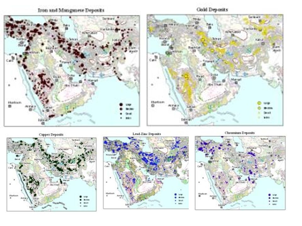
18
Minerals and Industrial Rocks Minerogenesis Map Of Iraq

19
Depth to the Crystalline Basement

20
Top of the Preserved Palaeozoic

21
Thickness of the Preserved Cambro-Ordovician Megasequence

22
Hercynian Basins Lignite Glass sand Kaolinite

23
Paleogeogrphic Reconstruction of the Late Triassic to Early Jurassic All wells drilled in Kurdistan till the present proved the lagoonal facies extends much further east than previously thought This megasequence (Late Permian- Liassic) is dominated by lagoonal evaporitic facies Zircon Rutile Ilmenite Bauxite Ironstone
 is dominated by lagoonal evaporitic facies Zircon Rutile Ilmenite Bauxite Ironstone")
24
Paleogeogrphic Reconstruction of the Late Tithonian to Cenomanian The Early Cretaceous was dominated by clastic deltaic influx from the west and development of carbonated ramps separating the shallow lagoons from the deep basin developed along the NE active margin of Arabia Fluvial Glass sand Possible Karst laterite

25
Tithonian-Turonian Megasequence Mosul High Rub al Khali Embayment Kirkuk Embayment

26
Paleogeogrphic Reconstruction of the Late Cretaceous The Late Cretaceous was dominated by the obduction of the Southern Neo- Tethys and the development of a flysch wedge along the NE margin of the Arabian Plate which was covered by a carbonate shelf interrupted by deeper water trantensional deep water basins Phosphate Bentonite Porcealinte Cr Iron Mn Cu

27
Upper Cretaceoos And Paleogene Phosphorite Control Upper Cretaceous Palaeogene

28
Cu Fe Au? Cr Ni Phosphate Bentonite Porceleanite Limestone

29
Mid Miocene Gypsum

30
Quaternary Brick Clay Gravel Sand Salt

31
Metallic Minerals

32
Northern Iraq

33
Northern Part Of NE Iraq

34
Southern Part Of NE Iraq

35
NeoTethys Domain Arabian Plate Domain Collision Zone Eocene Subduction Zones

36
Metallic Ores Zagros Crush Zone NeoTethys dismebered Ophiolites and volcanic arc-fore-arc Cu-Fe-Cr-Ni etc Sanadaj-Sirjan microplate Metamorphosed sediments And Intrusions Pb-Zn-Fe etc Urmieh-Dukhtar Zone Eocene Volcanic Arc Metallic-rich with Au

Similar presentations


, Baltica, and Siberia.>")


