Download presentation
Presentation is loading. Please wait.

1
Meteorology 6

2
MINI – REVIEW - first 15 slides – E6B TRIANGLE of VECTORS – FLIGHT PLANNING – AIRCRAFT POH TABLES – DRIFT – WINDS / CORIOLIS – UPPER WIND / CONTOUR LINES – FRONT DEVELOPMENT – GFA – CLOUDS & WEATHER

3
2700 @20 knots 34 NAUTICAL MILES track 042 0 T Heading ___@ 89 kts 270@20

4
20 K 270

5
042 T

6
2700 @20 knots Tail wind exists so consider a lower power setting. With 75% and 2600 rpm we get 101 airspeed and 115 kt groundspeed. With 55% and 2350 rpm we get 89 airspeed and 101 groundspeed. It makes a difference of 2 extra minutes! Engine stress is much less, fuel flow is less With 270@20

7
CRUISE HEIGHT Clouds based at 4000 ASL require 500 ft below cloud, or 3500 feet for cruise. Flying above these could mean tops at only 5500, but 500 ft above cloud would need 7500 cruise eastbound. Note: VFR OTT requires 1,000 feet separation 1,500 feet?

8
Temp -18C @ 6000 Power selection? Temp -14C @ 650 30.42 so it is -16C at 3500 Pres.alt.3,000

9
FLIGHT PLANNING LOG LINDSAY 042 270/20 34 89 HWY 7 CYKZ C-LING U. NOTME 032 101 2005/04/01 0+30 1.4 :20 cruise @ 4.2 gph

10
89 Ktas

11
-16C at a pressure altitude of 3,000 gives density altitude of 0 feet. Using the E6B a true speed of 89, also gives 89 Kcas. Add 3 to give 92 knots indicated speed.

13
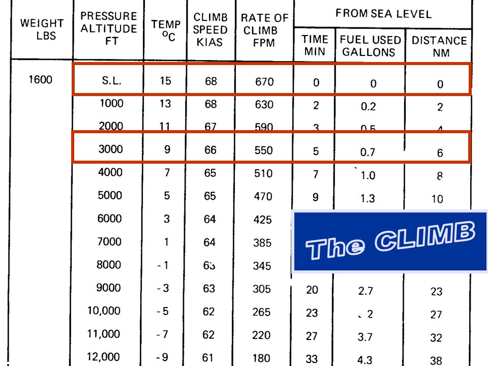
CLIMB SPEED -Best Rate? -Cruise Climb? -Best Angle?

14
FLIGHT PLANNING LOG LINDSAY 042 270/20 34 89 HWY 7 CYKZ C-LING U. NOTME 032 101 2006/04/01 0+30 67 35 92 6 :05 0.7 :20 1.4 0.4 :06 circuit :61 4.2

15
TILT MAP TO VISUALIZE LANDMARK DISTORTION DUE TO THE OBLIQUE VIEW FROM THE AIR.

17
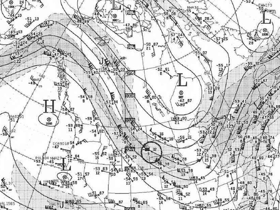
FRONTAL WAVE

18
FDs - low level FCST BASED ON 251200 DATA VALID 251800 FOR USE 17-21 3000 6000 9000 12000 18000 YAM 0117 3613-19 9900-21 9900-26 2408-35 note the backing winds in the descent over Ottawa YOW 0720 0814-13 1109-12 1614-15 1934-22 YQG 3309 3109-14 2707-16 2313-20 2232-28 YVV 0606 0305-15 9900-17 2016-20 2039-28 YYB 0406 9900-16 2009-17 2020-20 2043-28 YYZ04100506-139900-131909-171927-25 Fronts can show up in the vertical as wind shifts and varied lapse rates

19
SURFACE 2000 – 3000 feet 5-12 & 13 Wind Direction

20
Drift Direction

21
5-8 Geostrophic Wind

22
5-11 Surface Friction

23
Coriolis Force 5-7 Increases with wind strength Coriolis force greatest near poles –Ie. Coriolis can “pull” the wind to geostrophic sooner Therefore less wind needed to balance PGF near poles The pressure gradient or isobar spacing giving a 20k wind at 60° N latitude will give a 30k wind at 40° N latitude

24
5-9 Latitude Effect on Geostrophic Wind

27
7-16 Frontogenesis and 7-18 Frontolysis

28
TROWALS chap.8-12

29
Weather Locations

30
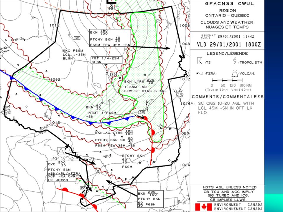
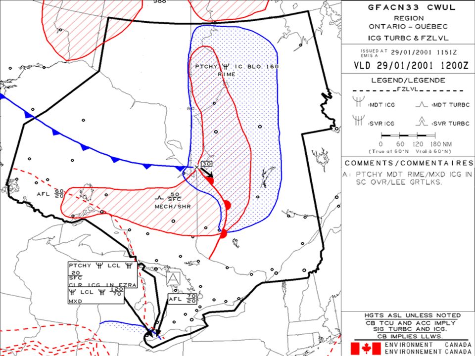
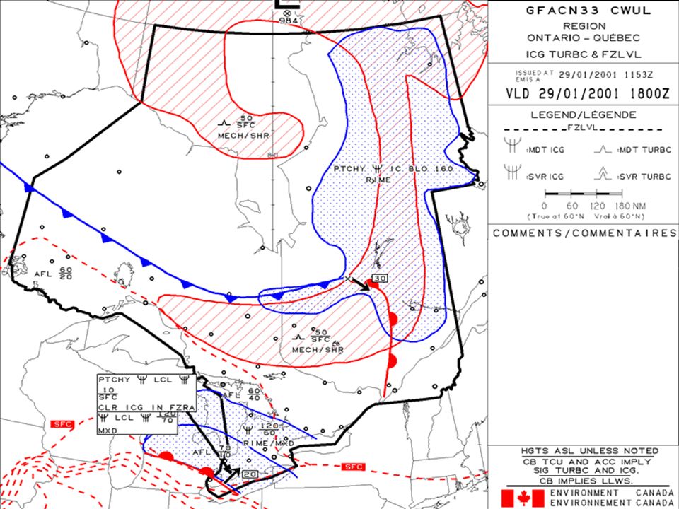
GFA REVIEW Issued at 2330Z, 0530Z, 1130Z and 1730Z Each GFA covers 12 hours with a 12 hour IFR outlook All of Canada covered with 7 GFA areas Heights are feet above sea level Section 3 of MET in AIP Movements (fronts, lows, etc.) less than 5k not indicated CU, TCU, CB and ACC will be indicated Winds less than 20 k usually not shown Amended GFA shows CCA, etc in title box
 less than 5k not indicated CU, TCU, CB and ACC will be indicated Winds less than 20 k usually not shown Amended GFA shows CCA, etc in title box")
Similar presentations


>")


