Download presentation
Presentation is loading. Please wait.

1
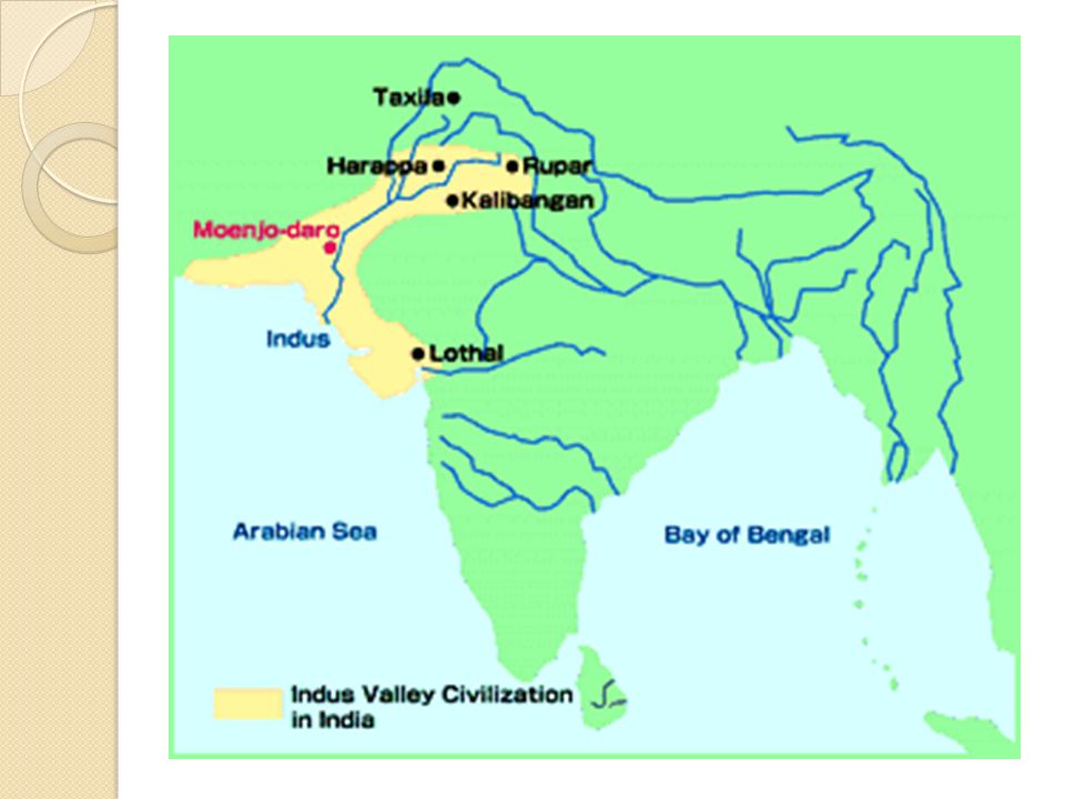
Indus River Valley (Harappa)
")
2
Day 1 Map of India Civilization- achievement Hierarchy- specialization Economy- surplus Barter- polytheism Monotheism - institution scribe

3
Day 2

4
Many Unknowns Archeological sites not excavated until the 1920’s Enormous territory Writing not yet deciphered Literally piecing together history

6
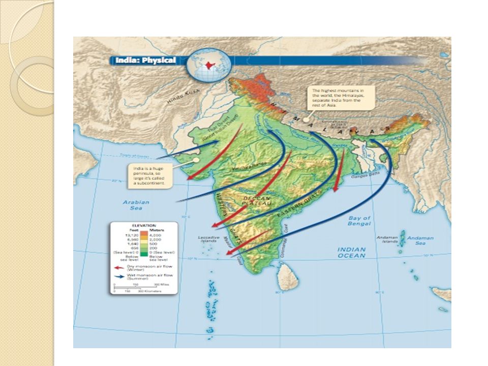
Indus River e Fertile Plain Hindu-Kush and Himalaya Mountain Ranges

7
Location, Location, Location! Geographic Benefits Geographic Benefits: Mountain Ranges offer protection Source of rivers Monsoons River Valley Perks: Flooding Soil Access to private beaches: Ports for trade

9
Monsoons Dominates climate Winter Monsoon (Oct-May) dry air from northeast Summer Monsoon (June) Summer Monsoon (June) picks up moisture from the Indian Ocean
 dry air from northeast Summer Monsoon (June) Summer Monsoon (June) picks up moisture from the Indian Ocean")
10
Monsoons depend on summer monsoons to provide rain People depend on summer monsoons to provide life giving rain latecrops die famine Monsoon late -crops die causing famine too much rain deadly floods Monsoon brings too much rain-rivers overflow causing deadly floods

11
In Comparison….. How does the geography and climate of the Indus River Valley compare to other river valley (agrarian ) civilizations we have studied? Make a prediction: Will the Indus River Valley civilization evolve in a similar fashion to Egypt and Mesopotamia or will it develop unique qualities we have yet to see? Decide on an answer and defend your argument in a well written paragraph.
 civilizations we have studied. Make a prediction: Will the Indus River Valley civilization evolve in a similar fashion to Egypt and Mesopotamia or will it develop unique qualities we have yet to see. Decide on an answer and defend your argument in a well written paragraph..")
12
DAY 3

13
Urbanized Society Planned cities Planned cities Mohenjo Daro Harappa grid pattern Laid out in grid pattern private neighborhoods Streets and alleyways off of major streets lead to private neighborhoods Houses with thick walls and high ceilings to keep the rooms cool in the hot summer months Houses of varying size Between1and 3 floors Same pattern – enclosed courtyard

14
Map of Mohenjo-Daro

15
Cities Centered On… Citadel-walled fortress that housed assembly halls, granaries, and public baths Citadel-walled fortress that housed assembly halls, granaries, and public baths

16
Cities Centered On… Crafts quarter/Central Market Crafts quarter/Central Market Evidence of workshops, beads, shell ornaments, glazed pottery ornaments, stone tools and even gold

17
Social Structure Ruling Elite Ruling Elite Not known if cities were ruled by priests or wealthy merchants Priest class Division of labor: City planners- Architects Merchants - Farmers Artisans housingsuggest social divisions were not great Similar housing structures suggest social divisions were not great

18
Political Structure-Central Gov’t Theocracy??? Theocracy??? Public Works: Public Works: Plumbing and sewage systems Public baths Granaries Levees Standardized measures and weights Walls for protection Floods Invasion Limited conflict Limited conflict Few weapons found …. Why?

19
Public Works Granary at Mohenjo-Daro World’s first sewage system?

20
Indus Valley (Harappan) Economy Irrigated agriculture Irrigated agriculture was used to take advantage of the fertile grounds along the Indus River Both brick and earthen walls were built to control the annual flooding Domesticated Animals Domesticated Animals included: Elephant Water Buffalo Oxen Goats
 Economy Irrigated agriculture Irrigated agriculture was used to take advantage of the fertile grounds along the Indus River Both brick and earthen walls were built to control the annual flooding Domesticated Animals Domesticated Animals included: Elephant Water Buffalo Oxen Goats")
21
Economic Resources Natural Resources Natural Resources timber Fresh water and timber Materials such as gold, silver, semi-precious stones Marine resources Agricultural Resources Domesticated crops included wheat, barley, peas, sesame seeds, dates and cotton First civilization to cultivate cotton for the production of cloth First civilization to cultivate cotton for the production of cloth

22
Trade central location Possible because of central location Exported timber Imported precious metals/stones trade with Mesopotamia Evidence of substantial trade with Mesopotamia buzzed with activity Marketplaces or crafts-quarters in cities like Mohenjo-Daro and Harappa buzzed with activity

23
Religion Not much is known Not much is known about religious practices No monumental symbols of religion Believed to be polytheistic Believed to be polytheistic: good harvests protection from floods Prayed for good harvests and protection from floods River often changed course Unpredictable flooding Animals

24
Religion worship of Statues and Figurines indicate worship of Mother goddess Fertility gods Links to Hinduism?

25
Religion belief in an afterlife Archeological evidence suggests belief in an afterlife

26
Technology Planned Cities: Straight streets in grid-like pattern Public water supply (baths) Public and private sanitation Standardization of: Standardization of: Weights Measurements Oven-baked bricks Distance Astronomy and Geometry?
 Public and private sanitation Standardization of: Standardization of: Weights Measurements Oven-baked bricks Distance Astronomy and Geometry")
27
Technology – Written Language Alphabet contained over 400 symbols Not yet deciphered Pictographic or Phonetic? Stamps and seals

28
Day 4

29
What happened to this Civilization? Everything we have examined about the Indus River Valley (Harappan) civilization to this point suggests that it was a well organized and thriving civilization. However, something happened that caused this civilization to vanish from history for close to 3,000 years. Many theories have been developed to explain the mysterious end to this early Indian civilization; some of which we will examine. Before looking at the theories take a few minutes and predict what historians believe was the true cause of the Harappan decline.
 civilization to this point suggests that it was a well organized and thriving civilization. However, something happened that caused this civilization to vanish from history for close to 3,000 years. Many theories have been developed to explain the mysterious end to this early Indian civilization; some of which we will examine. Before looking at the theories take a few minutes and predict what historians believe was the true cause of the Harappan decline..")
30
Theories between 2000 BC and 1500 BC cities were abandoned We do know that between 2000 BC and 1500 BC cities like Mohenjo-Daro and Harappa were abandoned two major theories There are two major theories that exist: Natural Catastrophe and Nomadic Invasion

31
The Case for Natural Disaster natural catastrophes or disasters led to the demise Some historians argue that natural catastrophes or disasters led to the demise of this great civilization earthquakes could have: Tectonic events such as earthquakes could have: Caused the river to migrate Shifted the river’s floodplains Climatic changes Climatic changes sustained drought Rainfall decreased and caused sustained drought

32
The Case for Natural Disaster Over farming depleted the soil Over farming and deforestation may have depleted the soil making it useless Evidence: Evidence: the river migrated Archeological work at Mohenjo-Daro suggests that the river migrated cities were believed to have been rebuilt several times Some cities were believed to have been rebuilt several times Plate boundary very close Indian Plate boundary very close now desert Most of the ancient civilization is now desert

33
The Case for Aryan Invasion Aryan Invasion theory suggests that pastoral nomads (Aryans) migrated and conquered Harappan settlements The Aryan Invasion theory suggests that pastoral nomads (Aryans) from the plains of Asia migrated and conquered Harappan settlements
 migrated and conquered Harappan settlements The Aryan Invasion theory suggests that pastoral nomads (Aryans) from the plains of Asia migrated and conquered Harappan settlements")
34
The Case for Aryan Invasion texts describe conquests Religious texts describe conquests of great cities traumatic deaths Human remains that suggest traumatic deaths Similarities between religious symbols Similarities between perceived religious symbols of Harappan cities and Hinduism Indo-European language Social structure - Varnas Social structure - Varnas

Similar presentations
 discovered here in the 1920s. TODAY’s.>")


 People Language.>")


>")
