Download presentation
Presentation is loading. Please wait.

1
Using GIS to Map Chromium Occurrence in Drinking Water Nate Rogers CEE 6440

2
Introduction Background of chromium Cr(III)↔Cr(VI) Health effects of chromium Cr(III) is a trace nutrient Cr(VI) is known carcinogen by inhalation, suspected by ingestion Sources of chromium in drinking water Source water: Naturally occurring, anthropogenic System infrastructure Treatment chemicals Regulations Maximum Contaminant Level (MCL) of 100 ppb TotCr (Cr(III) + Cr(VI)) Possible federal regulation of Cr(VI) California MCL = 10 ppb Cr(VI)
↔Cr(VI) Health effects of chromium Cr(III) is a trace nutrient Cr(VI) is known carcinogen by inhalation, suspected by ingestion Sources of chromium in drinking water Source water: Naturally occurring, anthropogenic System infrastructure Treatment chemicals Regulations Maximum Contaminant Level (MCL) of 100 ppb TotCr (Cr(III) + Cr(VI)) Possible federal regulation of Cr(VI) California MCL = 10 ppb Cr(VI)")
3
Population Data – 2010 Census Chromium Data – EPA 1996 - Safe Drinking Water Act (SDWA) Third Unregulated Contaminant Monitoring Rule (UCMR3) All Public Water Systems (PWS) serving <10,000 people Limitations Data linked by zip codes Data
 Third Unregulated Contaminant Monitoring Rule (UCMR3) All Public Water Systems (PWS) serving <10,000 people Limitations Data linked by zip codes Data")
4
Population

7
Total Chromium - Max

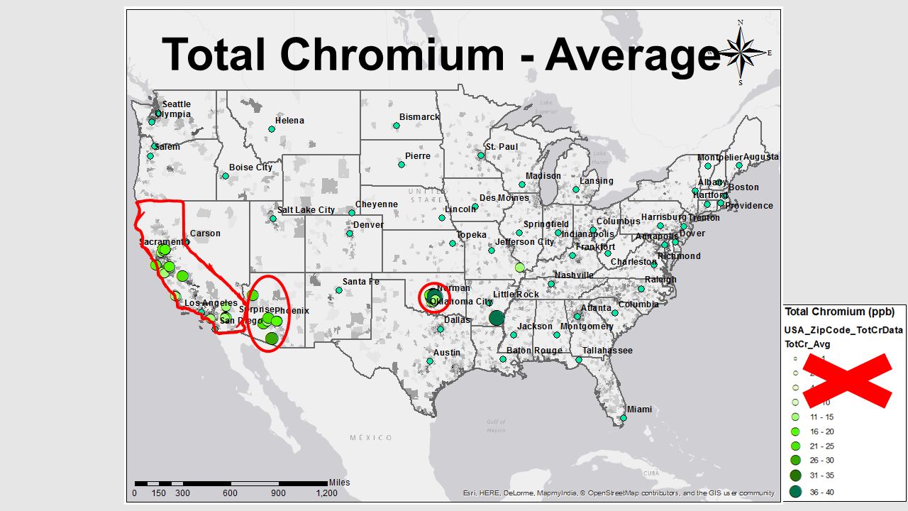
8
Total Chromium - Average

10
Chromium 6 - Max

11
Chromium 6 - Average

13
Cr6 Evaluation of Norman, OK

14
Summary & Next Steps Using GIS to analyze chromium occurrence in the US Identify areas requiring treatment system upgrades Affected populations Federal Regulation Feasibility California’s success Economic feasibility Utilize CUAHSI HydroDesktop Pinpoint sources of chromium Evaluate areas with large concentrations Mapping potential water sources without chromium

15
Questions?

Similar presentations


: 3.Maximum Containment Levels (MCL): - § 300g-1(b)(1)(A):>")


 Originally passed in 1974 Originally passed in 1974 Federal law that ensures the quality.>")


 The Safe Drinking Water Act (SDWA)>")


 Regulatory Determinations Water Quality Training Roundtable 2000 February 7, 2000.>")


 SAFE 210. Overview Enacted in 1974 to: Enacted in 1974 to: –Protect public health by regulating the nation’s public.>")