Download presentation
Presentation is loading. Please wait.

1
Integrating satellite fire and aerosol data into air quality models: recent improvements and ongoing challenges Edward Hyer Naval Research Laboratory 6 January 2016

2
In This Talk Why data assimilation? An example using trend analysis Improvements on many different fronts: – New data sources – Improved data processing methods – Improved data assimilation methods

3
Biases that matter for applications where long-term/large-area averages are used: clear-sky bias Levy et al. 2009 (MODIS C5 data) Top: May 2003 monthly mean AOD using equal- day weighting (for days with data) Bottom: bias in monthly mean from using per- pixel weighting This result hints at clear/cloud differences: can we analyze them directly?
 Top: May 2003 monthly mean AOD using equal- day weighting (for days with data) Bottom: bias in monthly mean from using per- pixel weighting This result hints at clear/cloud differences: can we analyze them directly .")
4
Biases that matter for applications where long-term/large-area averages are used: clear-sky bias Zhang and Reid (GRL 2009) used a model with data assimilation (ocean only) to examine clear-sky bias 24-hour model forecast mean vs. model sampled at locations with usable MODIS data +/-15% bias for June- August (2006-2008) shown This study needs to be repeated with ocean+land assimilation Combined implication of these two studies: 1.trends in cloud cover can show up as trends in observed AOD; 2.Data assimilation can yield a more accurate trend
 shown This study needs to be repeated with ocean+land assimilation Combined implication of these two studies: 1.trends in cloud cover can show up as trends in observed AOD; 2.Data assimilation can yield a more accurate trend.")
5
Data Assimilation for Aerosol Optical Depth MODIS AODMODIS RGB NAAPS “Natural”NAAPS + NAVDAS Approach used by Navy operational aerosol model shown at left Similar approaches are now used in multiple global+regional modeling systems

6
Data Assimilation for Aerosol Optical Depth MODIS AODMODIS RGB NAAPS “Natural”NAAPS + NAVDAS Three motivations for Aerosol Data Assimilation 1.Analysis covers the domain and is consistent with the (model) meteorology 2.Analysis can be used to initialize short-term forecast 3.Re-analysis provides the most complete description of the aerosol field over time
 meteorology 2.Analysis can be used to initialize short-term forecast 3.Re-analysis provides the most complete description of the aerosol field over time")
7
AOD trend based on global model reanalysis 2003-2013 AOD trend 2003-2013 (AOD/year x 100) [shaded = 95% statistical significance] Lynch et al. paper now in Geophysical Model Development Discussions Analyzed weather fields + satellite data used to constrain precipitation AOD constrained by assimilation of MODIS+MISR http://www.geosci-model-dev-discuss.net/8/10455/2015/gmdd-8-10455-2015.html
![AOD trend based on global model reanalysis AOD trend (AOD/year x 100) [shaded = 95% statistical significance] Lynch et al.](http://images.slideplayer.com/28/9333521/slides/slide_7.jpg "paper now in Geophysical Model Development Discussions Analyzed weather fields + satellite data used to constrain precipitation AOD constrained by assimilation of MODIS+MISR")
8
AOD trend based on global model reanalysis 2003-2013 AOD trend 2003-2013 (AOD/year x 100) [shaded = 95% statistical significance] Lynch et al. paper has: Very thorough description of global aerosol model Detailed discussion of all data inputs and model processes Comparative analysis of reanalysis trends vs observation-only trend studies http://www.geosci-model-dev-discuss.net/8/10455/2015/gmdd-8-10455-2015.html
![AOD trend based on global model reanalysis AOD trend (AOD/year x 100) [shaded = 95% statistical significance] Lynch et al.](http://images.slideplayer.com/28/9333521/slides/slide_8.jpg "paper has: Very thorough description of global aerosol model Detailed discussion of all data inputs and model processes Comparative analysis of reanalysis trends vs observation-only trend studies")
9
What can make model/satellite hybrids more accurate? More data – Geostationary data already shown to be important for mesoscale aerosol modeling Saide et al. GRL 2014; Lee et al. ACP 2014 More to come! (e.g. Yumimoto et al., GRL, in review) – Lidar gives vertical constraint Campbell et al. JAMC 2015 – What about nighttime? More accurate data More consistent data Better data assimilation approaches
 – Lidar gives vertical constraint Campbell et al. JAMC 2015 – What about nighttime. More accurate data More consistent data Better data assimilation approaches.")
10
Potential for nighttime AOD retrieval using Day/Night Band on VIIRS Aerosol causes blurring of city lights There are many challenges to quantify this signal Cape Verde, clear versus dusty skies Clear Dusty

11
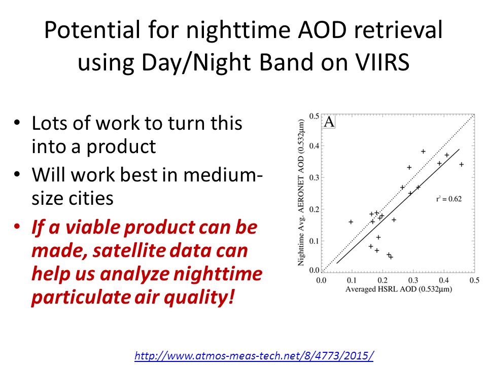
Potential for nighttime AOD retrieval using Day/Night Band on VIIRS Initial results show method has some skill Right: VIIRS DNB-derived AOD compared with AOD from HSRL at Huntsville, AL Paper in Atmospheric Measurement Techniques: McHardy et al., 2015 http://www.atmos-meas-tech.net/8/4773/2015/

12
Potential for nighttime AOD retrieval using Day/Night Band on VIIRS Lots of work to turn this into a product Will work best in medium- size cities If a viable product can be made, satellite data can help us analyze nighttime particulate air quality! http://www.atmos-meas-tech.net/8/4773/2015/
13
Making more consistent AOD products from MODIS data MODIS AOD products use the instrument scan to aggregate pixels This leads to distortion and overlap at the swath edge Right: figure from Sayer et al. AMT 2015 http://www.atmos-meas-tech.net/8/5277/2015/amt-8-5277-2015.html ODD SCANS EVEN SCANS ALL SCANS

14
Making more consistent AOD products from MODIS data Sayer et al. AMT 2015 tried to do better: 1.Aggregation by pixel proximity rather than by scan 2.Variable aggregation to get consistent footprint http://www.atmos-meas-tech.net/8/5277/2015/amt-8-5277-2015.html Variable Aggregation Standard Aggregation

15
Making more consistent AOD products from MODIS data This method obviously makes better imagery But it will also help data assimilation – Better understood error of representation – Simpler uncertainty model This method can (and should) be usefully applied to any polar orbiter data http://www.atmos-meas-tech.net/8/5277/2015/amt-8-5277-2015.html Variable Aggregation Standard Aggregation
 be usefully applied to any polar orbiter data Variable Aggregation Standard Aggregation")
16
Capturing Meteorological Context in Aerosol Data Assimilation 1 August 2013 Dust front has clear boundary Air masses ahead and behind dust from likely have important differences! AOD data for assimilation (colored) is sparse! How can we make the AOD analysis reflect these conditions?
 is sparse. How can we make the AOD analysis reflect these conditions .")
17
Capturing Meteorological Context in Aerosol Data Assimilation Rubin et al. ACPD 2015 Top: analysis using 2-D variation assimilation – ‘bullseyes’ in analysis increment – Aerosol mass added ahead of frontal boundary Bottom: analysis using ensemble Kalman filter – Uses 20-member ensemble of meteorology and source magnitude perturbations – Smoother analysis increment field – Aerosol mass contained behind dust front http://www.atmos-chem-phys-discuss.net/15/28069/2015/acpd-15-28069-2015.html

18
Capturing Meteorological Context in Aerosol Data Assimilation Rubin et al. ACPD 2015 Top: analysis using 2-D variation assimilation – ‘bullseyes’ in analysis increment – Aerosol mass added ahead of frontal boundary Bottom: analysis using ensemble Kalman filter – Uses 20-member ensemble of meteorology and source magnitude perturbations – Smoother analysis increment field – Aerosol mass contained behind dust front http://www.atmos-chem-phys-discuss.net/15/28069/2015/acpd-15-28069-2015.html This is a complex and computationally expensive method, but simulation of air quality in observation-poor areas (which include urban areas and coastal zones) requires some means of accounting for synoptic and mesoscale conditions when spreading information.
 requires some means of accounting for synoptic and mesoscale conditions when spreading information..")
19
What can make model/satellite hybrids more accurate? More data – Geostationary – Lidar – Nighttime? More accurate data More consistent data – Spatial representation matters as we get to finer model resolution – Consistent data simplifies error estimation for assimilation New datasets coming online bring dramatic improvements in all aspects of product quality Better data assimilation approaches – Incorporate dynamic meteorology – A joint analysis of aerosol and meteorology is the ideal; this turns out to be a very hard problem Thanks for your time!

20
Biases that matter for applications where long-term/large-area averages are used: persistent systematic bias Example: MODIS Collection 6 AOD slope (using only AERONET AOD > 0.2) as a function of the fraction of AERONET AOD from the fine mode This is a big improvement over Collection 5! (C5 Figure in Hyer et al. 2011) But the gray bars (fraction of high/low outliers) tell a similar story: In regions with predominantly coarse aerosols, expect MODIS C6 to underestimate slightly; for fine-mode aerosols, expect a slight overestimate
 But the gray bars (fraction of high/low outliers) tell a similar story: In regions with predominantly coarse aerosols, expect MODIS C6 to underestimate slightly; for fine-mode aerosols, expect a slight overestimate.")
Similar presentations


>")


 OMI NO2 Retrieval: Recent Trends in NO2 Ronald C. Cohen University of California, Berkeley $$ NASA.>")


