Download presentation
Presentation is loading. Please wait.

1
GII to RII to CII in South Africa Estelle de Coning South African Weather Service Senior Scientist

2
Content of presentation Background GII in SA RII in SA RII compared to model fields RII validation against lightning CII Summary and conclusion

3
Background Nowcasting and very short range forecasting (0-12 hours) Remote sensing Radar Lightning detection Satellite In SA we are lucky – we have it all! In SADC – not so lucky We (SAWS) work/research/develop for ourselves as well as for SADC…
 work/research/develop for ourselves as well as for SADC….")
4
GII in SA The SAWS has been receiving and displaying the MSG output since 2005. Pretty pictures Products

5
Pictures RGBs Overlay with radar and lightning data via SUMO software

6
GII in SA As radiosondes are only of very limited temporal and spatial resolution there is a demand for satellite-derived indices. The basis of the GII methodology is: Together with the satellite measured brightness temperatures and some a priori information of the atmospheric profile (from the Numerical Weather Prediction model) a local profile is derived, and instability indices are computed from this local profile.
 a local profile is derived, and instability indices are computed from this local profile..")
7
Products: GII’s K Index at 06:45 UTC

8
Regional Instability Indices (RII) A local version of the EUMETSAT MPEF GII product was installed in South Africa in September 2007. This Regional Instability Indices (RII) product is based on the same MSG channels as the MPEF products, but relies on the South African version of Unified Model (UM) instead of ECMWF. This implies that the RII’s horizontal resolution has improved from 1 degree to 0.1 degrees and the local product – running on local servers – can do the calculations in 3X3 pixels in stead of 15X15 pixels.
 product is based on the same MSG channels as the MPEF products, but relies on the South African version of Unified Model (UM) instead of ECMWF. This implies that the RII’s horizontal resolution has improved from 1 degree to 0.1 degrees and the local product – running on local servers – can do the calculations in 3X3 pixels in stead of 15X15 pixels..")
9
GII - ECMWF RII – Unified Model

10
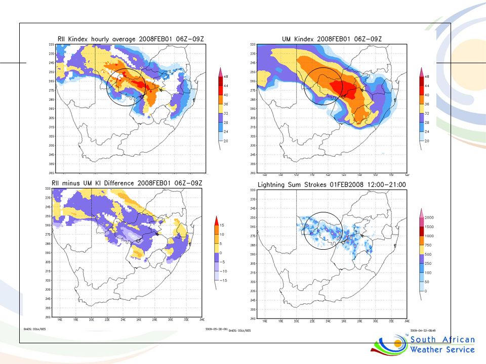
Comparing RII with model fields

11
RII – K Index

12
UM fields – K Index

13
Difference

16
Adjusting for SA The computation of the Lifted Index adjusted to local conditions (Sfc weight) Total Totals was added Challenge: The areas where KI and TT are not available due to the elevation (<850 hPa) since KI and TT depend on T and Td values at 850 hPa…
 Total Totals was added Challenge: The areas where KI and TT are not available due to the elevation (<850 hPa) since KI and TT depend on T and Td values at 850 hPa…")
17
Areas above 850 hPa

18
Modified K-Index Replace the 850 mb T and TD with a low altitude average We used 825 hPa for SA circumstances

19
K index over most of the country, but modified K Index where terrain is higher than 850 hPa

20
RII evaluation against lightning 50 cases over two summer seasons RIIs time averaged between 06:00 and 09:00 UTC Ligthning summarized between 12:00 and 21:00 UTC Contingency table approach POD, POFD, ACC, FAR, HK

21
CII (Combined Instability Index) One map, one parameter for a forecaster to use for the 3 to 9 hour lead time of convection in probabilities Use PW, MK, LI and MT and for each of them: Relate the parameter in the early morning (06:00- 09:00 UTC) against the occurrence of lightning (12:00-21:00) (using 50 case studies in the 2007/8 summer season Compile a “look-up” table… where a value of the index corresponds to a percentage chance that lightning occurs at that value Weigh the indices using the (HK) performance of the indices at different values (80%) Add topography as fifth, climatological parameter (20%)
 One map, one parameter for a forecaster to use for the 3 to 9 hour lead time of convection in probabilities Use PW, MK, LI and MT and for each of them: Relate the parameter in the early morning (06:00- 09:00 UTC) against the occurrence of lightning (12:00-21:00) (using 50 case studies in the 2007/8 summer season Compile a look-up table… where a value of the index corresponds to a percentage chance that lightning occurs at that value Weigh the indices using the (HK) performance of the indices at different values (80%) Add topography as fifth, climatological parameter (20%)")
22
Example of evaluation of improved CII against lightning: 3 Jan 2008

23
CII vs HE for 19 Sep 2009 This product is now available on RSMC website for SADC - Updated every hour from 07:20 to 1000 UTC

24
CII vs HE for 20 Sep 2009 HRV 1430Z DAYN 1430Z

25
Example 22 Sep 2009 CII at 08:00Z HE 1600Z

26
Advantages of CII: Not four different parameters to consider with their own thresholds One map – in probabilities (not thresholds) Improved aerial coverage where KI and TT could not cover due to elevation (MK and MT) Incorporates moisture (PW), instability (MK and MT) as well as a trigger mechanism (topography) – all the ingredients for convection to occur Developed based on occurrence of lightning (as verification of convection) in a 50-day-climatology Good correlation with lightning occurrence in very short range forecast situations for the tested cases and out performs the individual parameters!
 Improved aerial coverage where KI and TT could not cover due to elevation (MK and MT) Incorporates moisture (PW), instability (MK and MT) as well as a trigger mechanism (topography) – all the ingredients for convection to occur Developed based on occurrence of lightning (as verification of convection) in a 50-day-climatology Good correlation with lightning occurrence in very short range forecast situations for the tested cases and out performs the individual parameters!")
27
Summary and conclusion Thus far: GII – very useful RII – running on SAWS servers and providing easy access to adjust and improve RII – does add value to model fields RII – statistics with lightning occurrence looking good CII – all in one, probability of thunderstorms with 3-9 hour lead time (“ensembles principle”) Future work: Publication and PhD Using and improving Hydro-estimator as local nowcasting tool
 Future work: Publication and PhD Using and improving Hydro-estimator as local nowcasting tool")
Similar presentations


 Full range of products available at:>")


 is responsible for forecasts several times.>")


